Oromia Region
| Oromia State Oromiyaa | ||
|---|---|---|
| Region | ||
| ||
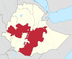 Map of Ethiopia showing Oromia Region | ||
| Country | Ethiopia | |
| Capital | Addis Ababa[1] | |
| Area | ||
| • Total | 284,538 km2 (109,861 sq mi) | |
| Population (2007) | ||
| • Total | 27,158,471 | |
| • Density | 95/km2 (250/sq mi) | |
| ISO 3166 code | ET-OR | |

Oromia (spelled Oromiyaa in the Oromo language; Amharic: ኦሮምያ?) is one of the nine ethnically based regional states of Ethiopia, covering 284,538 square kilometers.[2] It is bordered by the Somali Region to the east; the Amhara Region, the Afar Region and the Benishangul-Gumuz Region to the north; South Sudan, Gambela Region, and Southern Nations, Nationalities, and Peoples' Region to the west; and Kenya to the south. The 2007 census reported Oromia's population at over 27 million, making it the largest state in population and area.
Oromia includes the former Arsi Province along with portions of the former Bale, Hararghe, Illubabor, Kaffa, Shewa, Sidamo, and Welega provinces. Its current capital is Addis Ababa (Oromo: Finfinne); other important cities and towns include Adama, Dire Dawa, Harer, Ambo, Asella, Bishoftu, Chiro, Dembidolo, Fiche, Gimbi, Robe, Goba, Dello Buna, Jimma, Metu, Negele Boran, Moyale, Nekemte, Shashamane, Haramaaya and Waliso. The Region was the scene of large protests and a government crackdown which killed dozens of protesters in August 2016.
History

The region of Oromia was inhabited by ethnic communities for centuries. The earliest people to live in northern Oromia are believed to be Muslim Gurage people from southern Abyssinia.[3] The Sultanate of Ifat, Adal Sultanate, Sultanate of Showa, Kingdom of Damot, Kingdom of Ennarea, Ganz province, Sultanate of Bale, Maya, Hadiya Sultanate, Sultanate of Dawaro, Fatagar, Gumar, Gidim, Werjih, Gurage, Gafat were some of the kingdoms and peoples in the area before the 16th century Oromo expansion. Most of these ancient Kingdoms situated in present-day Oromia Region were semi-autonomous provinces of Abyssinian Empire.[4] The indigenous inhabitants were made Gabaros (serfs) and Oromized through collective adoption process known as Gudifacha and Mogasa. The affiliated groups were given new genealogies and started counting their putative ancestors in the same way as their adoptive kinsmen.[5] The native ancient names of the territories were replaced by the name of the Oromo clans who conquered it.[4][5]
Before 2000, the regional capital of Oromia was Addis Ababa, also known as "Finfinne" (in the Oromo language). The relocation of the regional capital to Adama sparked considerable controversy, and this forced the government to bring back the capital to Addis Ababa. Critics of the move believed the Ethiopian government wished to de-emphasize Addis Ababa's location within Oromia.[6][7] On the other hand, the government maintained that Addis Ababa "has been found inconvenient from the point of view of developing the language, culture and history of the Oromo people."[8]
On 10 June 2005, the Oromo People's Democratic Organization, part of the ruling coalition, officially announced plans to move the state capital back to Finfinne.[9]
Oromia shares a boundary with almost every region of Ethiopia except for the Tigray Region. This boundary has been disputed with Oromia's neighbors in a number of cases, most notably between Oromia and the Somali Region. One attempt to resolve the dispute between the two regions was the October 2004 referendum held in about 420 kebeles in 12 woredas across five zones of the Somali Region. According to the official results of the referendum, about 80% of the disputed areas have fallen under Oromia administration, though there were allegations of voting irregularities in many of them.[10] The results led over the following weeks to minorities in these kebeles being pressured to leave. In Oromya, estimates based on figures given by local woreda and kebele authorities suggest that 21,520 people have been displaced in border woredas, namely Mieso, Doba, and Erer in the Mirab and Misraq Hararghe Zones. Federal authorities believe that this number may be overstated by as much as 11,000. In Doba, the Ministry of Federal Affairs put the number of IDPs at 6,000. There are also more than 2,500 displaced persons in Mieso.[11] In addition, there were reports of people being displaced in the border area of Moyale and Borena zones due to this conflict.[12]
On 5 August 2016 protests broke out across Ethiopia and centered around the Oromia Region. Dozens of protesters were killed in the first days of the protests and internet service was cut to many parts of the region.
Demographics
Based on the 2007 census conducted by the Central Statistical Agency of Ethiopia (CSA), Oromia has a total population of 27,158,471, consisting of 13,676,159 men and 13,482,312 women; urban inhabitants number 3,370,040 or 11.3% of the population. With an estimated area of 353,006.81 square kilometers, this region has an estimated population density of 76.93 people per square kilometer. For the entire region 5,590,530 households were counted, which results in an average for the region of 4.8 persons to a household, with urban households having on average 3.8 and rural households 5.0 people.
In the previous census, conducted in 1994, the region's population was reported to be 18,732,525, of whom 9,371,228 were men and 9,361,297 women; urban inhabitants number 621,210 or 14% of the population.
According to the CSA, as of 2004, 32% of the population had access to safe drinking water, of whom 23.7% were rural inhabitants and 91.03% were urban.[13] Values for other reported common indicators of the standard of living for Oromia as of 2005 include the following: 19.9% of the inhabitants fall into the lowest wealth quintile; adult literacy for men is 61.5% and for women 29.5%; and the regional infant mortality rate is 76 infant deaths per 1,000 live births, which is about the same as the nationwide average of 77; at least half of these deaths occurred in the infants' first month of life.[14]
Ethnic groups
| Ethnic group | 1994 Census | 2007 Census |
|---|---|---|
| Oromo | 85% | 87.8% |
| Amhara | 9.1% | 7.22% |
| Gurage (some of Sebat Bet Gurage, Soddo Gurage, and Silt'e) | 0.98% | 0.93% |
| other ethnic groups | 4.6% | 4% |
Figures of full ethnic background are disputed, since many ethnically mixed Ethiopians are difficult to categorize. Particularly, Shewa Oromos and urban Oromos are known to have assimilated with ethnic Amhara and others, while southwestern Oromos have mixed with the Sidama and other ethnicities. The census and the general system of governance has remained controversial and related to the politics of the country. For instance, mixed Ethiopians with an Oromo father and Amhara mother are registered into the census using only their father's ethnic label. Similarly, Ethiopians with an Amhara father (or from another ethnic background) and Oromo mother are registered using only their father's ethnic label and counted as non-Oromo.
Religion
Religion in entire region
| Religion | 1994 Census | 2007 Census[15] |
|---|---|---|
| Muslim | 44.3% | 47.6% |
| Orthodox Christians | 41.3% | 30.4% |
| Protestant Christians | 8.6% | 17.7% |
| traditional religions | 4.2% | 3.3% |
| other religious groups | 1.6% | 1% |
Religion in urban areas
| Religion | 1994 Census | 2007 Census[15] |
|---|---|---|
| Orthodox Christians | 67.8% | 51.2% |
| Muslim | 24.0% | 29.9% |
| Protestant Christians | 7% | 17.5% |
| other religious groups | – | 1.5% |
Languages
Oromo (Oromiffa), which is written with Latin characters, is the most commonly spoken language, spoken by 83.5% of the population. Other major languages are Amharic (11%) (especially in eastern Welega and northern Shewa), Gurage languages (Sebat Bet Gurage, Soddo, Silt'e), Hadiya, Gedeo (0.98%), especially in western and eastern Shewa; and Tigrigna (0.25%). Omotic languages are spoken by significant minorities in Jimma, Illubabor and western Welega; and some Nilo-Saharan languages (including Komo, Majang, Gumuz, and Berta) are spoken in communities scattered in the west.
Economy
The CSA reported that for 2004–2005 115,083 tons of coffee were produced in Oromia, based on inspection records from the Ethiopian Coffee and Tea Authority. This represents 50.7% of the total production in Ethiopia. Farmers in the Region had an estimated total of 17,214,540 cattle (representing 44.4% of Ethiopia's total cattle), 6,905,370 sheep (39.6), 4,849,060 goats (37.4%), 959,710 horses (63.25%), 63,460 mules (43.1%), 278,440 asses (11.1%), 139,830 camels (30.6%), 11,637,070 poultry of all species (37.7%), and 2,513,790 beehives (57.73%).[16]
According to a March 2003 World Bank publication, the average rural household has 1.14 hectares of land compared to the national average of 1.01 hectares, 24% of the population is in non-farm related jobs compared to the national average of 25%.[17]
Presidents of the Executive Committee
- Hassan Ali (1992? – 1995)
- Kuma Demeksa (OPDO) (1995 – 24 July 2001)
- Junedin Sado (28 October 2001 – 6 October 2005)
- Abadula Gemeda (6 October 2005 – September 2010)
- Alemayehu Atomsa OPDO (September 2010 – Feb 2014)
- Muktar Kedir OPDO (March 2014 – 2016)[18][19]
Administrative zones
The Oromia is subdivided into administrative zones:
- Arsi
- Bale
- Borena
- East Hararghe
- East Shewa
- East Welega
- Guji
- Horo Gudru Welega
- Illubabor
- Jimma
- Kelem Welega
- North Shewa
- South West Shewa
- West Arsi
- West Hararghe
- West Shewa
- West Welega
- Adama (special zone)
- Jimma (special zone)
- Oromia-Finfinne (special zone)
See also
References
- ↑ "FDRE States: Basic Information, Oromia". The Federal Democratic Republic of Ethiopia. Retrieved 29 May 2008.
- ↑ 2011 National Statistics (accessed 7 May 2012).
- ↑ gurage muslim kingdom in shawa
- 1 2 Richard Pankhurst The Ethiopian Borderlands: Essays in Regional History from Ancient Times to the End of the 18th Century. The Red Sea Press (1997) pp. 35–300
- 1 2 Paul Trevor William Baxter, Jan Hultin, Alessandro Triulzi. Being and Becoming Oromo: Historical and Anthropological Enquiries. Nordic Africa Institute (1996) pp. 253–256
- ↑ Hameso, Seyoum and Tilahun Ayanou Nebo (2000). "Ethiopia: A New Start?". The Sidama Concern. Retrieved 25 February 2006.
- ↑ Mosisa, Abraham T. (13 January 2004). "Letter to U.N. Secretary-General". Oromo Studies Association. Retrieved 25 February 2006.
- ↑ "Nazareth Selected as Oromiya's Capital". Walta Information Center. 13 July 2000. Retrieved 25 February 2006.
- ↑ "Chief Administrator of Oromia says decision to move capital city based on study". Walta Information Center. 11 June 2005. Archived from the original on 13 June 2005. Retrieved 25 February 2006.
- ↑ "Somali-Oromo border referendum of December 2004", Internal Displacement Monitoring Centre website (accessed 11 February 2009)
- ↑ "Regional Overview: Oromiya Region", Focus on Ethiopia (April 2005), p. 5 (accessed 11 February 2009)
- ↑ "Regional Update: Oromiya", Focus on Ethiopia (May 2005), p. 5 (accessed 11 February 2009)
- ↑ "Households by sources of drinking water, safe water sources" (PDF). CSA Selected Basic Welfare Indicators. Retrieved 28 January 2009.
- ↑ Macro International Inc. Ethiopia Atlas of Key Demographic and Health Indicators, 2005 (PDF). Calverton: Macro International, 2008. 2008. pp. 2, 3, 10. Retrieved 28 January 2009.
- 1 2 Census 2007 Tables: Oromia Region Archived 13 November 2011 at the Wayback Machine., Table 3.3.
- ↑ "CSA 2005 National Statistics – Tables D.4 – D.7." (PDF).
- ↑ Klaus Deininger; et al. "Tenure Security and Land Related Investment, WP-2991". Retrieved 23 March 2006.
- ↑ http://www.oromowiki.com/wiki/BREAKING_NEWS_-_Muktar_Kedir_Becomes_the_New_President_of_the_Oromia_Region
- ↑ http://www.worldstatesmen.org/Ethiopia_Regions.html
External links
| Wikimedia Commons has media related to Oromia Region. |
- Map of Oromia Region at UN-OCHA (PDF file)
- Map of Oromia Region at DPPA of Ethiopia (PDF file)
- FDRE States: Basic Information – Oromia
Media

Coordinates: 7°59′21″N 39°22′52″E / 7.9890616°N 39.3811798°E