Orléans tramway
 | |||
| Overview | |||
|---|---|---|---|
| Native name | Tramway d'Orléans | ||
| Locale | Orléans, Centre, France | ||
| Transit type | Tram | ||
| Number of lines | 2 | ||
| Number of stations | 49 | ||
| Daily ridership | 42,000 (2010) | ||
| Operation | |||
| Began operation | 2000 | ||
| Operator(s) | Société d'Exploitation des Transports de l'Agglomération Orléanaise (SETAO) | ||
| Technical | |||
| System length | 29.3 km (18.2 mi) | ||
| Track gauge | 1,435 mm (4 ft 8 1⁄2 in) standard gauge | ||
| |||
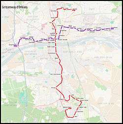
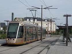
The Orléans tramway (French: Tramway d'Orléans) consists of two tram lines in the city of Orléans, Centre, France. Line A runs roughly north–south, and Line B roughly east–west. The lines cross at Place De Gaulle in the city centre.
Line A
This 18-kilometre (11 mi) north–south line connects Fleury-les-Aubrais with Orleans La Source, and serves 24 stations. The line is served by 22 trams.[1]
Line B
A second 11-kilometre (6.8 mi) east-west line was approved in 2005. The line connects the communes of La Chapelle-Saint-Mesmin, Saint-Jean-de-la-Ruelle, Orléans, and Saint-Jean-de-Braye, serving 25 stations, and opened in June 2012.[1][2] 21 Alstom Citadis 302 trams were ordered to provide the service.[2]
Ticketing
Several tram stops have ticket machines offering a variety of ticket types. As of February 2013, a standard single ticket cost €1.50. The same tickets can also be used on the local bus network.
See also
References
- 1 2 "Réseau bus - Tram" (in French). City of Orleans. Retrieved 2011-01-05.
- 1 2 "Urban rail news in brief". Railway Gazette International. 19 November 2008. Retrieved 2011-01-06.
External links
| Wikimedia Commons has media related to Orléans tramway. |