Orange Line (CTA)
| Orange Line | |||||||||||||||||||||||||||||||||||||||||||||||||||||||||||||||||||||||||||||||||||||||||||||||||||||||||||||||||||||||||||||||||||||||||||||||||||||||||||||||||||||||||||||||||||||||||||||||||||||||||||||||||||||||||||||||||||||||||||||||||||||||||||||||||||||||||||||||||||||||||||||||||||||||||||||||||||||||
|---|---|---|---|---|---|---|---|---|---|---|---|---|---|---|---|---|---|---|---|---|---|---|---|---|---|---|---|---|---|---|---|---|---|---|---|---|---|---|---|---|---|---|---|---|---|---|---|---|---|---|---|---|---|---|---|---|---|---|---|---|---|---|---|---|---|---|---|---|---|---|---|---|---|---|---|---|---|---|---|---|---|---|---|---|---|---|---|---|---|---|---|---|---|---|---|---|---|---|---|---|---|---|---|---|---|---|---|---|---|---|---|---|---|---|---|---|---|---|---|---|---|---|---|---|---|---|---|---|---|---|---|---|---|---|---|---|---|---|---|---|---|---|---|---|---|---|---|---|---|---|---|---|---|---|---|---|---|---|---|---|---|---|---|---|---|---|---|---|---|---|---|---|---|---|---|---|---|---|---|---|---|---|---|---|---|---|---|---|---|---|---|---|---|---|---|---|---|---|---|---|---|---|---|---|---|---|---|---|---|---|---|---|---|---|---|---|---|---|---|---|---|---|---|---|---|---|---|---|---|---|---|---|---|---|---|---|---|---|---|---|---|---|---|---|---|---|---|---|---|---|---|---|---|---|---|---|---|---|---|---|---|---|---|---|---|---|---|---|---|---|---|---|---|---|---|---|---|---|---|---|---|---|---|---|---|---|---|---|---|---|---|---|---|---|---|---|---|---|---|---|---|---|---|---|---|---|---|---|---|---|---|
|
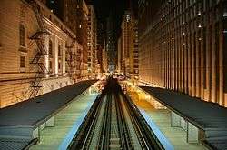
A Orange Line train of 3200-series cars. | |||||||||||||||||||||||||||||||||||||||||||||||||||||||||||||||||||||||||||||||||||||||||||||||||||||||||||||||||||||||||||||||||||||||||||||||||||||||||||||||||||||||||||||||||||||||||||||||||||||||||||||||||||||||||||||||||||||||||||||||||||||||||||||||||||||||||||||||||||||||||||||||||||||||||||||||||||||||
| Overview | |||||||||||||||||||||||||||||||||||||||||||||||||||||||||||||||||||||||||||||||||||||||||||||||||||||||||||||||||||||||||||||||||||||||||||||||||||||||||||||||||||||||||||||||||||||||||||||||||||||||||||||||||||||||||||||||||||||||||||||||||||||||||||||||||||||||||||||||||||||||||||||||||||||||||||||||||||||||
| Type | Rapid transit | ||||||||||||||||||||||||||||||||||||||||||||||||||||||||||||||||||||||||||||||||||||||||||||||||||||||||||||||||||||||||||||||||||||||||||||||||||||||||||||||||||||||||||||||||||||||||||||||||||||||||||||||||||||||||||||||||||||||||||||||||||||||||||||||||||||||||||||||||||||||||||||||||||||||||||||||||||||||
| System | Chicago "L" | ||||||||||||||||||||||||||||||||||||||||||||||||||||||||||||||||||||||||||||||||||||||||||||||||||||||||||||||||||||||||||||||||||||||||||||||||||||||||||||||||||||||||||||||||||||||||||||||||||||||||||||||||||||||||||||||||||||||||||||||||||||||||||||||||||||||||||||||||||||||||||||||||||||||||||||||||||||||
| Status | Operational | ||||||||||||||||||||||||||||||||||||||||||||||||||||||||||||||||||||||||||||||||||||||||||||||||||||||||||||||||||||||||||||||||||||||||||||||||||||||||||||||||||||||||||||||||||||||||||||||||||||||||||||||||||||||||||||||||||||||||||||||||||||||||||||||||||||||||||||||||||||||||||||||||||||||||||||||||||||||
| Locale | Chicago, Illinois, United States | ||||||||||||||||||||||||||||||||||||||||||||||||||||||||||||||||||||||||||||||||||||||||||||||||||||||||||||||||||||||||||||||||||||||||||||||||||||||||||||||||||||||||||||||||||||||||||||||||||||||||||||||||||||||||||||||||||||||||||||||||||||||||||||||||||||||||||||||||||||||||||||||||||||||||||||||||||||||
| Termini |
Midway The Loop | ||||||||||||||||||||||||||||||||||||||||||||||||||||||||||||||||||||||||||||||||||||||||||||||||||||||||||||||||||||||||||||||||||||||||||||||||||||||||||||||||||||||||||||||||||||||||||||||||||||||||||||||||||||||||||||||||||||||||||||||||||||||||||||||||||||||||||||||||||||||||||||||||||||||||||||||||||||||
| Stations | 16 | ||||||||||||||||||||||||||||||||||||||||||||||||||||||||||||||||||||||||||||||||||||||||||||||||||||||||||||||||||||||||||||||||||||||||||||||||||||||||||||||||||||||||||||||||||||||||||||||||||||||||||||||||||||||||||||||||||||||||||||||||||||||||||||||||||||||||||||||||||||||||||||||||||||||||||||||||||||||
| Daily ridership |
63,037 (avg. weekday September 2012) | ||||||||||||||||||||||||||||||||||||||||||||||||||||||||||||||||||||||||||||||||||||||||||||||||||||||||||||||||||||||||||||||||||||||||||||||||||||||||||||||||||||||||||||||||||||||||||||||||||||||||||||||||||||||||||||||||||||||||||||||||||||||||||||||||||||||||||||||||||||||||||||||||||||||||||||||||||||||
| Operation | |||||||||||||||||||||||||||||||||||||||||||||||||||||||||||||||||||||||||||||||||||||||||||||||||||||||||||||||||||||||||||||||||||||||||||||||||||||||||||||||||||||||||||||||||||||||||||||||||||||||||||||||||||||||||||||||||||||||||||||||||||||||||||||||||||||||||||||||||||||||||||||||||||||||||||||||||||||||
| Opened | October 31, 1993 | ||||||||||||||||||||||||||||||||||||||||||||||||||||||||||||||||||||||||||||||||||||||||||||||||||||||||||||||||||||||||||||||||||||||||||||||||||||||||||||||||||||||||||||||||||||||||||||||||||||||||||||||||||||||||||||||||||||||||||||||||||||||||||||||||||||||||||||||||||||||||||||||||||||||||||||||||||||||
| Operator(s) | Chicago Transit Authority | ||||||||||||||||||||||||||||||||||||||||||||||||||||||||||||||||||||||||||||||||||||||||||||||||||||||||||||||||||||||||||||||||||||||||||||||||||||||||||||||||||||||||||||||||||||||||||||||||||||||||||||||||||||||||||||||||||||||||||||||||||||||||||||||||||||||||||||||||||||||||||||||||||||||||||||||||||||||
| Character | Elevated and Surface Level | ||||||||||||||||||||||||||||||||||||||||||||||||||||||||||||||||||||||||||||||||||||||||||||||||||||||||||||||||||||||||||||||||||||||||||||||||||||||||||||||||||||||||||||||||||||||||||||||||||||||||||||||||||||||||||||||||||||||||||||||||||||||||||||||||||||||||||||||||||||||||||||||||||||||||||||||||||||||
| Rolling stock | 2600-series, 3200-series | ||||||||||||||||||||||||||||||||||||||||||||||||||||||||||||||||||||||||||||||||||||||||||||||||||||||||||||||||||||||||||||||||||||||||||||||||||||||||||||||||||||||||||||||||||||||||||||||||||||||||||||||||||||||||||||||||||||||||||||||||||||||||||||||||||||||||||||||||||||||||||||||||||||||||||||||||||||||
| Technical | |||||||||||||||||||||||||||||||||||||||||||||||||||||||||||||||||||||||||||||||||||||||||||||||||||||||||||||||||||||||||||||||||||||||||||||||||||||||||||||||||||||||||||||||||||||||||||||||||||||||||||||||||||||||||||||||||||||||||||||||||||||||||||||||||||||||||||||||||||||||||||||||||||||||||||||||||||||||
| Line length | 12.5 mi (20.1 km) | ||||||||||||||||||||||||||||||||||||||||||||||||||||||||||||||||||||||||||||||||||||||||||||||||||||||||||||||||||||||||||||||||||||||||||||||||||||||||||||||||||||||||||||||||||||||||||||||||||||||||||||||||||||||||||||||||||||||||||||||||||||||||||||||||||||||||||||||||||||||||||||||||||||||||||||||||||||||
| Track gauge | 4 ft 8 1⁄2 in (1,435 mm) | ||||||||||||||||||||||||||||||||||||||||||||||||||||||||||||||||||||||||||||||||||||||||||||||||||||||||||||||||||||||||||||||||||||||||||||||||||||||||||||||||||||||||||||||||||||||||||||||||||||||||||||||||||||||||||||||||||||||||||||||||||||||||||||||||||||||||||||||||||||||||||||||||||||||||||||||||||||||
| Minimum radius | 90 feet (27 m) | ||||||||||||||||||||||||||||||||||||||||||||||||||||||||||||||||||||||||||||||||||||||||||||||||||||||||||||||||||||||||||||||||||||||||||||||||||||||||||||||||||||||||||||||||||||||||||||||||||||||||||||||||||||||||||||||||||||||||||||||||||||||||||||||||||||||||||||||||||||||||||||||||||||||||||||||||||||||
| Electrification | Third rail, 600 V DC | ||||||||||||||||||||||||||||||||||||||||||||||||||||||||||||||||||||||||||||||||||||||||||||||||||||||||||||||||||||||||||||||||||||||||||||||||||||||||||||||||||||||||||||||||||||||||||||||||||||||||||||||||||||||||||||||||||||||||||||||||||||||||||||||||||||||||||||||||||||||||||||||||||||||||||||||||||||||
| |||||||||||||||||||||||||||||||||||||||||||||||||||||||||||||||||||||||||||||||||||||||||||||||||||||||||||||||||||||||||||||||||||||||||||||||||||||||||||||||||||||||||||||||||||||||||||||||||||||||||||||||||||||||||||||||||||||||||||||||||||||||||||||||||||||||||||||||||||||||||||||||||||||||||||||||||||||||
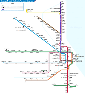
The Orange Line, is a rapid transit line in Chicago, Illinois run by the Chicago Transit Authority as part of the "L" system. It is approximately 12.5 miles (20.1 km) long and runs at grade and elevated on existing railroad embankments and new concrete and steel structures from Midway International Airport, the Southwest Side and downtown Chicago. In September 2012, the average weekday boardings on the Orange Line were 63,037. The Orange Line operates between Midway Airport and the Loop, weekdays from 4:00 a.m. to 1:25 a.m., and Saturdays and Sundays from 4:30 a.m. to 1:25 a.m.
Route
The Orange Line begins in an open cut at a station on the east side of Midway International Airport. From here, the line rises to an elevated viaduct at 55th Street and continues northeast towards the city on railroad right-of-way. At Lawndale Avenue the line turns east along Conrail right-of-way at 49th Street to a point east of Western Boulevard, then curves north and northwest on embankment structure along CSX and Conrail right-of-way to Western Boulevard and Pershing Road.
From here, the line rises on elevated structure again and makes a curve to cross Archer Avenue, the Conrail tracks and Western Boulevard before descending onto Illinois Central (ex-Gulf, Mobile and Ohio) Railroad right-of-way immediately east of Western Boulevard. Entering the IC right-of-way, the line again changes from elevated structure to surface level. The line continues on surface level to Ashland Avenue where it crosses the bridge of the South Branch of the Chicago River. At this point, the line enters the joint Illinois Central and Atchison, Topeka and Santa Fe Railroad right-of-way continuing on embankment to Canal Street.
There the line again transitions to the elevated structure to bridge Canal Street, Cermak Road and the Chicago & Western Indiana Railroad tracks then curves east to run along the south side of 18th Street, crossing over the Red Line and the Rock Island District tracks near Wentworth Avenue, before joining the South Side Elevated at a flying junction between 16th and 17th Streets. The ballasted track ends and the timber deck begins here. Orange Line trains share the tracks with the Green Line operating from this junction to Tower 12 at the southeast corner of the Loop. Orange Line trains operate clockwise around the inner loop - via Van Buren Street, Wells Street, Lake Street and Wabash Avenue - before returning to Midway.
Along the Orange Line's main route there are seven stations. An eighth station is located at Roosevelt/Wabash on the old South Side 'L' which Orange Line trains share with Green Line trains. A passenger tunnel connects this station with the Roosevelt/State subway station on the Red Line.
A downtown superstation has been proposed to provide express service from the Loop to O'Hare and Midway, via the Orange and Blue Lines. The station would provide services such as baggage check. The downtown terminal is under construction, but the express tracks required for the Airport Express trains have yet to be funded.
Rolling stock
The Orange Line is operated with the 2600-series railcars and the Morrison-Knudsen-built 3200-series railcars which were delivered a year before the opening of the route. From November 8, 2012 to October 31, 2014, some 2400-series railcars were assigned to the line. Trains operate using eight cars during weekday rush hours and four cars during other times on weekdays and all day on weekends except for special events when eight cars may be required. A non-rush hour four car Orange Line train consists of two 2600-series cars and two 3200-series cars or four 2600-series cars or four 3200-series cars. The Orange Line's 2600-series cars are expected to remain in service on the line until the 2020s, where they will be replaced by the future 7000-series cars. The Orange Line's 3200-series cars will be replaced by the future 7000-series cars in the 2020s if all options are picked up, otherwise the 3200-series cars will remain in service on the line until the 2030s if the options are not picked up. Meanwhile, CTA is currently in the process of overhauling the 3200-series cars with color LED destination signs (similar to the 5000-series cars), new air conditioning systems, and rebuilt propulsion systems, passenger door motors, and wheel/axle assemblies. The 3200-series rehabilitation began in 2015 and will be completed in 2017.
Beginning in June 2014, CTA began to transfer some 2600-series cars to the line as an interim replacement for its 2400-series cars. The first batch of the Orange Line's 2600-series cars are reassignments from the Blue Line, where the lost capacity on the Blue Line is made up from reassignment of 2600-series cars from the Red Line, which are newer than the existing Blue Line cars, as they are displaced by the new Bombardier-built 5000-series cars on the Red Line. The second batch of 2600-series cars are reassignments from the Red Line as more 5000-series cars are delivered and assigned to the Red Line, replacing the Orange Line's remaining 2400-series cars until the Red Line is fully equipped with the 5000-series cars. The last 2400-series cars were retired from service on October 31, 2014. After the Red Line is fully equipped with the 5000-series cars, The CTA planned on replacing the Orange Line's 2600-series cars with 5000-series cars, leaving only the Blue and Brown Lines as the only lines not to operate 5000-series cars. However, the assignment of 5000-series cars to the Orange Line is now unlikely, since delivery of all 5000-series cars is complete and are completely assigned to all other lines except for the Blue and Brown Lines, thus the assignment of 2600-series cars to the Orange Line is now a permanent assignment until the delivery of the future 7000-series cars.
History
The Orange Line opened for service on October 31, 1993, and was the first all-new service in Chicago since the Dan Ryan Line opened in September 1969 and the first extension to the CTA system since the O'Hare Airport Extension of the Blue Line in September 1984. But its planning dates back to the late 1930s when the City of Chicago proposed a high speed subway extension along Wells-Archer-Cicero between the Loop and 63rd Street and Cicero Avenue near Chicago Midway International Airport (then called Chicago's Municipal Airport). It would be another four decades before Chicago transit planners would become serious about providing rapid transit service to this area of the city.
In 1979, the City began the Southwest Transit Project, which proposed extending the CTA 'L' system to the Southwest Side of Chicago over existing railroad rights-of-way and newer elevated connections along the very busy Archer-49th-Cicero Corridor from the Loop to its originally planned terminus at Ford City Shopping Center. Funding for the project was made possible from Interstate Highway Transfer monies saved after the city decided to cancel the high priced and controversial Crosstown Expressway and Franklin Street Subway projects. Federal funding for the project was secured by U.S. Representative William Lipinski as a favor from then-President Ronald Reagan, who wanted to thank Lipinski for his vote to provide aid to the Nicaraguan contras.[1]
In 1987, construction of the $510 million transit line began and continued until fall 1993. When the Midway Line opened, the CTA decided to adopt a color-coded naming system for the rapid transit network (like Boston, Washington D.C., Cleveland) and named it the Orange Line.
Proposed extension
Destination sign on CTA trains have a line on the blind bearing the following text: Ford City.[2] The Ford City Mall is about two miles (3 km) south of Midway Airport, and it was originally planned to be the line's terminal. However, because of financial shortfalls, the city decided to end the line at Midway Airport.
The CTA recently undertook an Alternatives Analysis for the Orange Line extension to Ford City and determined that the project currently stands at an estimated $200 million. Community meetings were held in neighborhoods surrounding Midway and Ford City to judge the level of public support for the extension.[3]
In the August 2008 Screen 1 of the Alternatives Analysis, the four corridors being studied for the Orange Line extension include alignments along Cicero Avenue, Pulaski Road, and a combination of the Belt Railway and either Cicero or Kostner Avenues. The corridors selected for further study are Cicero Ave (Bus Rapid Transit) and Belt/Cicero or Belt/Kostner (Heavy Rail Transit).[4] For Screen 2 in April 2009, the Cicero Avenue/Belt Railway corridor was chosen as the most viable option and advanced in the Alternatives Analysis process.[5] By December 2009, the CTA had identified the Locally Preferred Alternative (LPA) as the Belt/Cicero route. According to a CTA report,
The LPA would operate in a trench along the BRC right-of-way between the existing Midway station and approximately 6400 South, where it would begin to transition to an elevated structure above Marquette Road, where it would curve to the southwest over the BRC Clearing Yard and then continue south on elevated structure in the median of Cicero Avenue. The Orange Line extension would end at a new terminal station in the vicinity of Ford City Mall."[6]
The CTA planned to prepare a draft Environmental Impact Statement (EIS) and complete preliminary engineering. Design and construction is allowed to start after the Federal Transit Administration approves the Final EIS.[7]
Station listing
After stopping at Adams/Wabash, Orange Line trains return to Roosevelt/Wabash, then make all stops back to Midway.
References
- ↑ Chicago-'L'.org - Orange Line
- ↑ Jon Hilkevitch. Signs mark growth of CTA Chicago Tribune, 30 October 2006.
- ↑ CTA Press Release, August 13, 2008
- ↑
- ↑
- ↑ http://www.transitchicago.com/assets/1/planning/Orange_Line_Extension_Locally_Preferred_Alternative_Report.pdf , p. 60
- ↑ "Project Schedule". Orange Line Extension. Chicago Transit Authority. Retrieved December 18, 2009.