Oppegård
| Oppegård kommune | |||
|---|---|---|---|
| Municipality | |||
| |||
 Oppegård within Akershus | |||
| Coordinates: 59°47′33″N 10°47′25″E / 59.79250°N 10.79028°ECoordinates: 59°47′33″N 10°47′25″E / 59.79250°N 10.79028°E | |||
| Country | Norway | ||
| County | Akershus | ||
| District | Follo | ||
| Administrative centre | Kolbotn | ||
| Government | |||
| • Mayor (1995) | Ildri Eidem Lovaas (H) | ||
| Area | |||
| • Total | 37 km2 (14 sq mi) | ||
| • Land | 34 km2 (13 sq mi) | ||
| Area rank | 424 in Norway | ||
| Population (2008) | |||
| • Total | 23,964 | ||
| • Rank | 37 in Norway | ||
| • Density | 681/km2 (1,760/sq mi) | ||
| • Change (10 years) | 8.0 % | ||
| Demonym(s) | Oppegårding[1] | ||
| Time zone | CET (UTC+1) | ||
| • Summer (DST) | CEST (UTC+2) | ||
| ISO 3166 code | NO-0217 | ||
| Official language form | Bokmål | ||
| Website |
www | ||
|
| |||

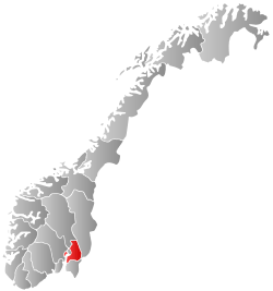
Oppegård is a village and municipality in Akershus county, Norway. It is part of the traditional region of Follo. The administrative centre of the municipality is the village of Kolbotn. The new municipality of Oppegård was separated from the municipality of Nesodden on 1 July 1915. The municipality has an area of 37 square kilometres (14.3 sq mi), hence it is the smallest municipality in Akershus by area.
General information
Name
The municipality (originally the parish) is named after the old Oppegård farm (Old Norse: Uppigarđr), since the first church was built here. The first element is uppi which means "upper" and the last element is garđr which means "farm". (The farm is probably a part of an older and bigger farm.)
Coat-of-arms
The coat-of-arms is from modern times. They were granted on 6 August 1976. The arms show 17 gold triangles on a black background. The 17 triangles symbolize 17 trees, which again symbolize the 17 old farms in the municipality. Most of the farms lie in an area called Svartskog ('black forest'), so the arms are canting arms.[2][3]
| Ancestry | Number |
|---|---|
| | 432 |
| | 316 |
| | 300 |
| | 165 |
| | 153 |
| | 151 |
| | 126 |
| | 124 |
| | 117 |
| | 114 |
History
Oppegård has been populated since the end of the last ice age. Archeological remains of hunter-gatherer societies dating back to 5000–6000 BCE have been found, as well as the remains of agriculatural settlements from 1000–2000 BCE. The main southern roads connecting Oslo to Sweden and Denmark have passed through Oppegård since the Iron Age.
The present-day municipality was created from the eastern part of the municipality of Nesodden in 1915. At the time, the population of Oppegård was only 600. The 1960s and 1970s saw a population boom, as larger housing projects established the Oppegård villages as suburbs of Oslo. The commercial centres along the main railroad axis is examples of the functionalist architecture characteristic of that period of urbanization in Scandinavia.
Arctic explorer Roald Amundsen lived in Svartskog and his house is now a museum, administered by the municipality. Svartskog is also home to a medieval stone church, and is likely the oldest settlement in Oppegård.
Politics
Since 1968, coinciding with the population boom, the Conservative Party of Norway (Høyre) has held either a majority or plurality of representatives in the municipal council. Several leading politicians for Høyre began their political careers as mayors of Oppegård, including Rolf Presthus (mayor from 1968–1970, Conservative Party Leader and Minister of Finance) and Jan Petersen (mayor from 1975-1981, Conservative Party Leader and Minister of Foreign Affairs). Oppegård is demographically an urban middle class area, demographically similar to Bærum and Asker and a traditional stronghold for Høyre.
Former Prime Minister and leader of the Christian Democratic Party Kjell Magne Bondevik lives in Oppegård.
Party representation in the Council 2007-2011
Conservatives: 15 Labour: 7 Progress Party: 4 Liberal Party: 2 Socialist Left: 2 Christian People's Party: 1
The Mayor is Ildrid Eidem Lovaas from the Conservatives. They govern with support from the Christian People's Party.
Geography
Oppegård is located at the eastern coast of Bunnefjorden (originally called "Foli", like the Årungen lake to the south), which is an arm of Oslofjord. It includes the villages Oppegård, Svartskog, and Kolbotn. The landscape is dominated by a vast part of the north-south oriented lake Gjersjøen, which roughly divides the district into western and eastern sections. The lake Kolbotnvannet is located here as well. The undeveloped areas are largely covered by forest.
Oppegård is a largely residential suburb of Oslo, but also a business hub. It hosts the Norwegian headquarters of several larger corporations (including Kodak and IBM) within its borders. Tax revenues from large corporations made Oppegård one of Norway's richest municipalities in the 1980s and 1990s. These revenues, and the wealth they brought, were lost in the 2000s when corporations were made to pay taxes directly to the national government, rather than the local government.
Commuter trains connect Oppegård to Oslo, and makes the neighbourhoods close to the train stations (Rosenholm, Kolbotn, Solbråtan, Myrvoll, Greverud, and Oppegård) popular residential areas.
Sister cities
The following cities are twinned with Oppegård:[5]
-
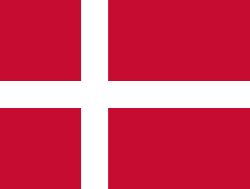 - Hvidovre, Region Hovedstaden, Denmark
 -
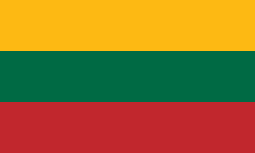 - Širvintos, Vilnius County, Lithuania
 -
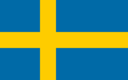 - Sollentuna, Stockholm County, Sweden
 -
 - Tuusula, Uusimaa, Finland
References
- ↑ "Navn på steder og personer: Innbyggjarnamn" (in Norwegian). Språkrådet. Retrieved 2015-12-01.
- ↑ Norske Kommunevåpen (1990). "Nye kommunevåbener i Norden". Retrieved 2008-12-20.
- ↑ "Kommunevåpenet" (in Norwegian). Oppegård kommune. Retrieved 2008-12-20.
- ↑ "Immigrants and Norwegian-born to immigrant parents, by immigration category, country background and percentages of the population". ssb.no. Retrieved 29 June 2015.
- ↑ "Vennskapskommuner" (in Norwegian). Oppegård kommune. Retrieved 2008-12-20.
External links
| Wikimedia Commons has media related to Oppegård. |
| Look up Oppegård in Wiktionary, the free dictionary. |
- Municipal fact sheet from Statistics Norway
 Akershus travel guide from Wikivoyage