Opochetsky District
| Opochetsky District Опочецкий район (Russian) | |
|---|---|
.svg.png) Location of Opochetsky District in Pskov Oblast | |
| Coordinates: 56°43′N 28°39′E / 56.717°N 28.650°ECoordinates: 56°43′N 28°39′E / 56.717°N 28.650°E | |
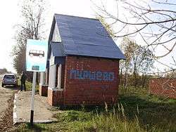 A bus stop in the village of Purshevo in Opochetsky District | |
| Location | |
| Country | Russia |
| Federal subject | Pskov Oblast[1] |
| Administrative structure (as of April 2011) | |
| Administrative center | town of Opochka[2] |
| Inhabited localities:[2] | |
| Cities/towns | 1 |
| Rural localities | 519 |
| Municipal structure (as of April 2011) | |
| Municipally incorporated as | Opochetsky Municipal District[2] |
| Municipal divisions:[2] | |
| Urban settlements | 1 |
| Rural settlements | 7 |
| Statistics | |
| Area | 2,028.9 km2 (783.4 sq mi)[3] |
| Population (2010 Census) | 18,673 inhabitants[4] |
| • Urban | 62.1% |
| • Rural | 37.9% |
| Density | 9.2/km2 (24/sq mi)[5] |
| Time zone | MSK (UTC+03:00)[6] |
| Official website | |
| Opochetsky District on WikiCommons | |
Opochetsky District (Russian: Опо́чецкий райо́н) is an administrative[1] and municipal[2] district (raion), one of the twenty-four in Pskov Oblast, Russia. It is located in the southwest of the oblast and borders with Pushkinogorsky District in the north, Novorzhevsky District in the northeast, Bezhanitsky District in the east, Pustoshkinsky District in the southeast, Sebezhsky District in the south, and with Krasnogorodsky District in the west. The area of the district is 2,028.9 square kilometers (783.4 sq mi).[3] Its administrative center is the town of Opochka.[2] Population: 18,673 (2010 Census);[4] 23,973 (2002 Census);[7] 28,877 (1989 Census).[8] The population of Opochka accounts for 62.1% of the district's total population.[4]
Geography
The whole of the district lies in the basin of the Velikaya River, and, consequently, of the Narva River. The Velikaya crosses the district from south to north, and the town of Opochka is located on its banks. The biggest tributaries of the Velikaya within the district are the Issa (left), the Alolya (right), and the Shest (right).
The western part of the district is flat and swampy, and the eastern part is hilly. In the southeast there are many lakes of glacial origin, the biggest of which are Lakes Velye and Kamennoye.[9]
History
Opochka was first mentioned in 1414.[10] At the time, it was a fortress subordinate to Pskov and protecting it from the south. In the course of the administrative reform carried out in 1708 by Peter the Great, the area was included into Ingermanland Governorate (known since 1710 as Saint Petersburg Governorate). Opochka is specifically mentioned as one of the towns making up the governorate. In 1727, separate Novgorod Governorate was split off, and in 1772, Pskov Governorate (which between 1777 and 1796 existed as Pskov Viceroyalty) was established. Between 1772 and 1776, Opochka was the seat of the governorate.[11] In 1776, the borders of the governorate were considerably altered, its seat was relocated to Pskov, and Opochka became the seat of Opochetsky Uyezd.
On August 1, 1927, the uyezds were abolished, and Opochetsky District was established, with the administrative center in the town of Opochka. It included parts of former Opochetsky Uyezd. The governorates were abolished as well, and the district became a part of Pskov Okrug of Leningrad Oblast. On July 23, 1930, the okrugs were also abolished, and the districts were directly subordinated to the oblast. On January 1, 1932, parts of abolished Krasnogorodsky District were merged into Opochetsky District. On January 29, 1935, the district was transferred to Kalinin Oblast, and on February 5 of the same year, Opochetsky District became a part of Velikiye Luki Okrug of Kalinin Oblast, one of the okrugs abutting the state boundaries of the Soviet Union. On March 5, 1935, Krasnogorodsky District was re-established. On May 11, 1937, Opochka Okrug with the seat in Opochka was established, and the district was transferred to the okrug. On February 5, 1941, the okrug was abolished. Between 1941 and 1944, Opochetsky District was occupied by German troops. On August 22, 1944, the district was transferred to newly established Velikiye Luki Oblast. On October 2, 1957, Velikiye Luki Oblast was abolished and Opochetsky District was transferred to Pskov Oblast.[12]
On August 1, 1927, Kudeversky District with the administrative center in the selo of Kudever was also established. It included parts of former Novorzhevsky Uyezd. The district was a part of Pskov Okrug of Leningrad Oblast. On September 20, 1931, Kudeversky District was abolished and merged into Novorzhevsky District. On March 5, 1935, it was re-established as a part of Velikiye Luki Okrug of Kalinin Oblast; on May 11, 1937, the district was transferred to Opochka Okrug. On August 22, 1944, the district was transferred to Velikiye Luki Oblast. On October 2, 1957, Velikiye Luki Oblast was abolished and Kudeversky District was transferred to Pskov Oblast. On January 14, 1958, Kudeversky District was abolished and split between Bezhanitsky, Novorzhevsky, Opochetsky, and Pustoshkinsky Districts.[12]
Economy
Industry
There are enterprises of food and textile industries in Opochka.[13]
Transportation
The M20 Highway which connects St. Petersburg and Vitebsk via Pskov crosses the district from north to south, passing Opochka. Another road connects Opochka with Sebezh and further with Polotsk. The whole stretch between Opochka and Polotsk has been a toll road since 2002.[14] There are also local roads.
None of the rivers within the district are navigable.
Culture and recreation
The district contains eight cultural heritage monuments of federal significance and additionally ninety-two objects classified as cultural and historical heritage of local significance.[15] The federally protected monuments are the Intercession Church, the postal station, the Kukolkin House, and the Chernyshyov House, all in Opochka, as well as four archeological sites.
References
Notes
- 1 2 Law #833-oz
- 1 2 3 4 5 6 Law #420-oz
- 1 2 О районе (in Russian). Портал муниципальных образований Псковской области. Retrieved August 10, 2012.
- 1 2 3 Russian Federal State Statistics Service (2011). "Всероссийская перепись населения 2010 года. Том 1" [2010 All-Russian Population Census, vol. 1]. Всероссийская перепись населения 2010 года (2010 All-Russia Population Census) (in Russian). Federal State Statistics Service. Retrieved June 29, 2012.
- ↑ The value of density was calculated automatically by dividing the 2010 Census population by the area specified in the infobox. Please note that this value is only approximate as the area specified in the infobox does not necessarily correspond to the area of the entity proper or is reported for the same year as the population.
- ↑ Правительство Российской Федерации. Федеральный закон №107-ФЗ от 3 июня 2011 г. «Об исчислении времени», в ред. Федерального закона №271-ФЗ от 03 июля 2016 г. «О внесении изменений в Федеральный закон "Об исчислении времени"». Вступил в силу по истечении шестидесяти дней после дня официального опубликования (6 августа 2011 г.). Опубликован: "Российская газета", №120, 6 июня 2011 г. (Government of the Russian Federation. Federal Law #107-FZ of June 31, 2011 On Calculating Time, as amended by the Federal Law #271-FZ of July 03, 2016 On Amending Federal Law "On Calculating Time". Effective as of after sixty days following the day of the official publication.).
- ↑ Russian Federal State Statistics Service (May 21, 2004). "Численность населения России, субъектов Российской Федерации в составе федеральных округов, районов, городских поселений, сельских населённых пунктов – районных центров и сельских населённых пунктов с населением 3 тысячи и более человек" [Population of Russia, Its Federal Districts, Federal Subjects, Districts, Urban Localities, Rural Localities—Administrative Centers, and Rural Localities with Population of Over 3,000] (XLS). Всероссийская перепись населения 2002 года [All-Russia Population Census of 2002] (in Russian). Retrieved August 9, 2014.
- ↑ Demoscope Weekly (1989). "Всесоюзная перепись населения 1989 г. Численность наличного населения союзных и автономных республик, автономных областей и округов, краёв, областей, районов, городских поселений и сёл-райцентров" [All Union Population Census of 1989: Present Population of Union and Autonomous Republics, Autonomous Oblasts and Okrugs, Krais, Oblasts, Districts, Urban Settlements, and Villages Serving as District Administrative Centers]. Всесоюзная перепись населения 1989 года [All-Union Population Census of 1989] (in Russian). Институт демографии Национального исследовательского университета: Высшая школа экономики [Institute of Demography at the National Research University: Higher School of Economics]. Retrieved August 9, 2014.
- ↑ Географическая характеристика (in Russian). Портал муниципальных образований Псковской области. Retrieved August 13, 2012.
- ↑ О районе (in Russian). Администрация Опочецкого района. Retrieved August 14, 2012.
- ↑ Коломыцева, Н. В. Псковской губернии 225 лет (in Russian). Краеведческий архив Псковской области. Retrieved August 14, 2012.
- 1 2 Герасимёнок, Т. Е.; Н. В. Коломыцева, И. С. Пожидаев, С. М. Фёдоров, К. И. Карпов (2002). Территориальное деление Псковской области (in Russian). Pskov. ISBN 5-94542-031-X.
- ↑ Справочник предприятий Псковской области (in Russian). Справочник предприятий Псковской области. Retrieved August 14, 2012.
- ↑ Псковская обл. Платные дороги (in Russian). АСМАП. Retrieved October 16, 2012.
- ↑ Памятники истории и культуры народов Российской Федерации (in Russian). Russian Ministry of Culture. Retrieved 2 June 2016.
Sources
- Псковское областное Собрание депутатов. Закон №833-оз от 5 февраля 2009 г. «Об административно-территориальном устройстве Псковской области». Вступил в силу со дня официального опубликования. Опубликован: "Псковская правда", №20, 10 февраля 2009 г. (Pskov Oblast Council of Deputies. Law #833-oz of February 5, 2009 On the Administrative-Territorial Structure of Pskov Oblast. Effective as of the official publication date.).
- Псковское областное Собрание депутатов. Закон №420-оз от 28 февраля 2005 г. «Об установлении границ и статусе вновь образуемых муниципальных образований на территории Псковской области», в ред. Закона №1542-ОЗ от 5 июня 2015 г. «О внесении изменений в Закон Псковской области "Об установлении границ и статусе вновь образуемых муниципальных образований на территории Псковской области"». Вступил в силу со дня официального опубликования. Опубликован: "Псковская правда", №41–43, №44–46, №49–51, 4 марта 2005 г., 5 марта 2005 г., 11 марта 2005 г. (Pskov Oblast Council of Deputies. Law #420-oz of February 28, 2005 On Establishing the Borders and the Status of the Newly Formed Municipal Formations on the Territory of Pskov Oblast, as amended by the Law #1542-OZ of June 5, 2015 On Amending the Law of Pskov Oblast "On Establishing the Borders and the Status of the Newly Formed Municipal Formations on the Territory of Pskov Oblast". Effective as of the official publication date.).
| Cities and towns | ||
|---|---|---|
| Districts | ||