Oostanaula River

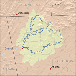
The Oostanaula River (pronounced "oo-stuh-NA-luh") is a principal tributary of the Coosa River, about 49 miles (79 km) long,[1] in northwestern Georgia in the United States. Via the Coosa and Alabama rivers, it is part of the watershed of the Mobile River, which flows to the Gulf of Mexico.
Etymology
Folklore explanations for its name state that Oostanaula is derived from a Cherokee language term meaning "rock that bars the way". Other similar explanations include "shoally river",[2] and "a rock ledge across a stream".
The original version of this word, which was the name of a pre-Cherokee Muskogean-Uchean province, appeared in the memoirs of Captain René de Laundonnière, Commander of Fort Caroline (1564-1565). He did not personally visit this powerful province, in what is now Northern Georgia, but one of his officers, La Roche Ferrière did.[3] De Laundonnière named the province, Houstaqua. This French spelling is what is shown on late 16th century and early 17th century maps of present-day Georgia. Late 17th century and early 18th century maps labeled this ethnic group either Ustanaqua or Ustanauli.[4] Late 18th century and early 19th century maps of Georgia either spelled the word Eastanolee or similarly to its current spelling. For example, the 1810 Daniel Sturges Map of Georgia spells the word, Oos-te-nau-lah.[5]
Course
The Oostanaula River is formed in northern Gordon County, Georgia, by the confluence of the Conasauga and Coosawattee rivers, and flows generally south-southwestwardly through Gordon and Floyd counties, past the towns of Resaca and Calhoun. It joins the Etowah River at Rome to form the Coosa River.
Variant names
According to the GNIS, the river has also been known as:
- Estanola River
- Estanole River
- Oostenauleh River
- Oostennallah River
- Oostinawley River
- Oustanale River
- Oustanalee River
- Ustanali River
On this 1796 map the river is labelled "Eastanallee R."
See also
References
- ↑ U.S. Geological Survey. National Hydrography Dataset high-resolution flowline data. The National Map, accessed April 27, 2011
- ↑ "Floyd County". Calhoun Times. September 1, 2004. p. 73. Retrieved 24 April 2015.
- ↑ Bennett, Charles E (2001) Three Voyages. Tuscaloosa: University of Alabama Press; pp. 77, 95, 116.
- ↑ Barnwell, Colonel John (1722) Map of the Province of South Carolina.
- ↑ Sturges, Daniel (1810) A Map of the State of Georgia according to the latest authorities. Hargrett Library Rare Map Collection, University of Georgia.
- Columbia Gazetteer of North America entry
- U.S. Geological Survey Geographic Names Information System: Oostanaula River
Coordinates: 34°15′14″N 85°10′36″W / 34.25389°N 85.17667°W