Old Bethpage, New York
| Old Bethpage, New York | |
|---|---|
| Hamlet and census-designated place | |
 | |
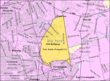
 Location in Nassau County and the state of New York. | |
 Location within the state of New York | |
| Coordinates: 40°45′43″N 73°27′16″W / 40.76194°N 73.45444°WCoordinates: 40°45′43″N 73°27′16″W / 40.76194°N 73.45444°W | |
| Country | United States |
| State | New York |
| County | Nassau |
| Area | |
| • Total | 4.1 sq mi (10.7 km2) |
| • Land | 4.1 sq mi (10.7 km2) |
| • Water | 0.0 sq mi (0.0 km2) |
| Elevation | 174 ft (53 m) |
| Population (2010) | |
| • Total | 5,523 |
| • Density | 1,347.1/sq mi (516.2/km2) |
| Time zone | Eastern (EST) (UTC-5) |
| • Summer (DST) | EDT (UTC-4) |
| ZIP code | 11804 |
| Area code(s) | 516 |
| FIPS code | 36-54551 |
| GNIS feature ID | 0959252 |
Old Bethpage is a hamlet and census-designated place (CDP) located on Long Island in the Town of Oyster Bay, Nassau County, New York, USA. The population of the CDP was 5,523 at the 2010 census.[1] It is served by the Old Bethpage Post Office, ZIP code 11804.
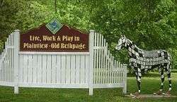
Old Bethpage and its neighboring hamlet, Plainview, share a school system, library, fire department and water district. Law enforcement for the community is provided by the Nassau County Police Department's Eighth Precinct.
History
In 1695, Thomas Powell bought about 10,000 acres (40 km2) from local Indian tribes, including the Marsapeque, Matinecoc, and Sacatogue, for 140 English pounds. This land, which includes present day Bethpage, East Farmingdale, Farmingdale, Old Bethpage, Plainedge, Plainview, South Farmingdale, and part of Melville, is known as the Bethpage Purchase and is approximately 3.5 miles (5.6 km) east to west and 5 miles (8.0 km) north to south.
Powell called his land Bethphage, because it was situated between two other places on Long Island, Jericho and Jerusalem, just as the biblical town of Bethphage (meaning "house of figs") was situated between Jericho and Jerusalem. Today, the Long Island place formerly called Jerusalem is known as Wantagh and Island Trees, while the placename Jericho is unaltered. Over time, Bethpage was spelled without the second "H". Powell's 14 children split up his purchase and it evolved into several farming communities, and the one in this mostly central part of the purchase retained the name "Bethpage".
A railroad spur completed in 1873, known as the Bethpage Branch of the Central Railroad of Long Island,[2] ran to a brickworks plant which had opened in Old Bethpage in the 1860s. The railway was built to transport bricks for the construction of Alexander Stewart's Garden City.[3][4] For a few years, regularly scheduled passenger traffic also appeared in timetables, with the station being called Bethpage. The line was abandoned in 1942. Remnants of a locomotive turntable can be found in the woods of Bethpage State Park on the east side of Round Swamp Road.[5][6] The brickyard continued operations under different owners until 1981, with different sections known variously as Bethpage Brickworks, Queens County Brick Manufacturing Company, Post Brick Company, and (after Nassau County split from Queens County in 1899) Nassau Brick Company.[7] The pitted terrain at the brickworks was used in investigations by Grumman for digital mapping of Earth.[8]
In 1908, William Kissam Vanderbilt II began construction of the Long Island Motor Parkway, one of the country's first highways. Eventually stretching 45 miles (72 km) from Queens to Lake Ronkonkoma, New York, a portion of the parkway ran through Old Bethpage. Street names such as "Vanderbilt Lane", "Motor Parkway" and "Toll Place" serve as reminders. Segments of the old roadbed and some bridges can still be seen in some places, including Battle Row Campground, Bethpage State Park, and the Old Bethpage Village Restoration.[9]
In 1932, under the auspices of Long Island State Parks Commissioner, Robert Moses, Bethpage State Park, was opened. The park and its 1,400 acres (5.7 km2) is almost entirely within the hamlet of Old Bethpage. In 1936, the adjacent hamlet of Central Park changed its name to Bethpage.[10] Following this name change, the hamlet originally called Bethpage resisted suggestions that it merge with the new Bethpage, and got approval from the post office to change its name to Old Bethpage, though it did not have its own post office until 1965.[11] Bethpage State Park remained so named, leading some to mistakenly believe that the park is located mostly in Bethpage.

Old Bethpage was home to at least two grand estates, the Benjamin Franklin Yoakum Estate and the Taliaferro Estate.
- The former estate of railroad tycoon Benjamin F. Yoakum included land in both Old Bethpage and the Lenox Hills neighborhood of Farmingdale Village. It was this estate that was transformed into Bethpage State Park.
- The Taliaferro Estate is now the site of the Nassau County Office Complex, located between the split of Old Country Road and Round Swamp Road, and was once home to the Nassau County Sanitarium, a tuberculosis ward. The sanitarium was authorized by the Nassau County Board of Supervisors in 1930, and was completed in the early part of the same decade.[12][13] As tuberculosis was brought under control, the complex of Georgian style buildings was closed in the 1960s.[14] Following its closure, the facility was given over to mixed use, including the establishment of a drug and alcohol rehabilitation center in 1976, and a branch of the Cornell Cooperative Extension.[14][15] In 1999, Charles Wang, founder of Computer Associates purchased the 144-acre (0.58 km2) property from the county for $23 million.[16] Included in the purchase was 1535 Old Country Road, which now houses the corporate offices of the New York Islanders and New York Dragons, both of which are owned by Wang. In addition, the building is home to the Wang-created, Plainview Chinese Cultural Center.[17]
In 1960, responding to Nassau County's rapid suburban expansion, the county announced plans for the development of the Nassau County Fire Service Academy. Located on Winding Road, the academy provides training to all Nassau County fire departments.[18]
Geography
Old Bethpage is located at 40°45′43″N 73°27′16″W / 40.76194°N 73.45444°W (40.761819, -73.454544).[19] For the 2000 Census, the boundaries of the CDP were enlarged beyond those of the 1990 census.[20]
According to the United States Census Bureau, Old Bethpage has a total area of 4.1 square miles (11 km2). Although Plainview, at 5.7 square miles (15 km2) is 40% larger, its population is approximately five times that of Old Bethpage because significant portions of Old Bethpage consist of parks and undeveloped property, including, Bethpage State Park, the Old Bethpage Village Restoration and Battle Row Campground.
Demographics of the CDP
As of the 2000 United States Census,[21] there were 5,400 people, 1,834 households, and 1,557 families residing in the CDP. The population density was 1,311.4 per square mile (506.1/km²). There were 1,843 housing units at an average density of 447.6/sq mi (172.7/km²). The racial makeup of the CDP was 94.57% White, 1.19% African American, 0.04% Native American, 2.94% Asian, 0.35% from other races, and 0.91% from two or more races. Hispanic or Latino of any race were 1.93% of the population.
There were 1,834 households out of which 38.3% had children under the age of 18 living with them, 75.6% were married couples living together, 7.1% had a female householder with no husband present, and 15.1% were non-families. 13.8% of all households were made up of individuals and 10.5% had someone living alone who was 65 years of age or older. The average household size was 2.88 and the average family size was 3.16.
In the CDP the population was spread out with 24.2% under the age of 18, 5.5% from 18 to 24, 27.1% from 25 to 44, 25.1% from 45 to 64, and 18.0% who were 65 years of age or older. The median age was 41 years. For every 100 females there were 91.6 males. For every 100 females age 18 and over, there were 90.5 males.
The median income for a household in the CDP was $89,771, and the median income for a family was $100,325. Males had a median income of $67,917 versus $40,353 for females. The per capita income for the CDP was $34,666. About 2.4% of families and 4.3% of the population were below the poverty line, including 4.0% of those under age 18 and 4.6% of those age 65 or over.
School system
Old Bethpage's school system is the Plainview-Old Bethpage Central School District. This school district contains one high school, two middle schools, four elementary schools and a kindergarten center. Of these schools, the only one located in Old Bethpage proper is Old Bethpage Elementary School.
Old Bethpage also had its own two room school house named the Little Red Schoolhouse. This building, which stood until the 1970s, was located on Schoolhouse Road, just off of Round Swamp Road. The building was torn down and the property developed into several houses.
Recreation
Parks
Old Bethpage has a number of community parks tucked in between its homes. For residents, the primary park is the Old Bethpage Park, located on Haypath Road. This park features two tennis courts, baseball and softball fields, a basketball court, playgrounds and a community center. For out-of-towners, the town is also home to the Battle Row Campground, which provides accommodations for trailers and tent camping on its 44 acres (180,000 m2).[11]
Old Bethpage contains Bethpage State Park which has five golf courses, the most famous of which is the Black Course, where the US Open was held in 2002 and again in 2009.
Entertainment
Old Bethpage is home to the Old Bethpage Village Restoration.[22] Opened in 1963, on a former Powell family farm, the restoration is an authentic recreation of a mid-19th century Long Island village. The complex includes farmhouses, a blacksmith, general store, cobbler, school house and churches, all of which were moved to the site from other locations on Long Island and then restored to period condition.[23][24][25] In 2009, the Restoration became one of six Nassau County museums slated to be closed as a result of the county's impending budget shortfall. However, as a result of strong public opposition, the museum opened on April 1, 2009.[26]
Old Bethpage was home to one movie theater, located in the Tru-Value Shopping Center. This theater initially showed first or second run movies. However, in the 1970s it began to show pornographic movies until community protests forced the theater to revert to its original general commercial offerings.[27] The theater eventually closed and remained vacant for a number of years until it was reopened as a live action theater known as the Plaza Playhouse. The Playhouse remained in Old Bethpage until June 2010, when it moved to a new strip mall on Old Country Road. The space is now occupied by a gym.
Sports
Hawks Youth Lacrosse is the local Boys and Girls Youth Lacrosse organization for Plainview-Old Bethpage with teams playing in the Nassau County PAL League.www.hawkslax.org
Old Bethpage is home to "Skate Safe of America", which provides facilities for roller hockey and other indoor sports.
References
Bibliography
- "Our Town: Life in Plainview-Old Bethpage 1600 Through Tomorrow", by Richard Koubek, published in 1987
Notes
- ↑ "2010 Demographic Profile Data:Old Bethpage CDP".
- ↑ "Railroad Extension" (PDF). NY Times. 1873-08-01. Retrieved 2008-04-01.
- ↑ "Plainview-Old Bethpage Chamber of Commerce".
- ↑ "Stewart Line and Stewart Brick Works".
- ↑ "Central Railroad of Long Island- Bethpage Turntable".
- ↑ "Long Island Motor Parkway Exploration Continuation Page 2".
- ↑ "Battle Row Campground". Retrieved 2010-04-27.
- ↑ Halajian, John (2007). Moon Stories: A Roadmap to Lunar Exploration and Beyond. Retrieved 2010-04-27.
- ↑ "Long Island Motor Parkway Page 7".
- ↑ "Metropolitan Area Loses One of Its Central Parks" ($ PDF $). NY Times. 1936-10-03.
- 1 2 Kellerman, Vivien (1996-08-18). "A Hop, Skip and Jump to Life's Amenities". NY Times. Retrieved 2008-04-01.
- ↑ Encyclopedia of the Unincorporated Village of Bethpage
- ↑ Unknown (1932-04-14). "$5,000,000 Bonds For Nassau County". NY Times. Retrieved 2008-03-31.
- 1 2 McMorrow, Fred (1976-11-07). "Beyond the Drunk Tank". NY Times. Retrieved 2008-04-03.
- ↑ "NY Camping Review".
- ↑ "Newsday article on Wang purchase".
- ↑ "Charles Wang Foundation Donates Plainview Chinese School to Enrich Asian Cultural Offerings For Long Islanders".
- ↑ "Nassau Starts Fire School". The New York Times. 1960-07-21.
- ↑ "US Gazetteer files: 2010, 2000, and 1990". United States Census Bureau. 2011-02-12. Retrieved 2011-04-23.
- ↑ "New York: 2000 Population and Housing Unit Counts" (PDF). September 2003. p. III-9. Retrieved 2010-12-22.
- ↑ "Old Bethpage CDP". U.S. Census Bureau. 2000. Retrieved 2010-05-29.
- ↑ Old Bethpage Village Restoration
- ↑ Field Trip.com
- ↑ "Nassau Is Planning 19th-Century Town on Tract For Park". NY Times. 1963-05-08. Retrieved 2008-04-06.
- ↑ Silver, Roy R. (1970-05-07). "Person With Skills of the 1800s Sought For The Restoration In Nassau". NY Times. Retrieved 2008-04-06.
- ↑ Murphy, William; Bleyer, Bill (2009-02-09). "Person Nassau union heads to testify on county layoff bill". Newsday. Retrieved 2009-02-09.
- ↑ Court document
External links
- Plainview-Old Bethpage Central School District
- Plainview-Old Bethpage Library
- Plainview-Old Bethpage Fire Department
- Old Bethpage Village Restoration
- 1903 map showing Old Bethpage as Bethpage (including LIRR tracks)
- Old Bethpage Village photo gallery