Okotoks
| Okotoks | ||
|---|---|---|
| Town | ||
| Town of Okotoks | ||
|
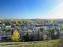
A view of Okotoks; overlooking downtown and facing south. | ||
| ||
| Motto: Historic Past, Sustainable Future | ||
 Okotoks | ||
| Coordinates: 50°43.5′N 113°58.5′W / 50.7250°N 113.9750°WCoordinates: 50°43.5′N 113°58.5′W / 50.7250°N 113.9750°W | ||
| Country |
| |
| Province |
| |
| Region | Calgary Region | |
| Census division | 6 | |
| Municipal district | M.D. of Foothills No. 31 | |
| Incorporated[1] | ||
| • Village | October 25, 1899 | |
| • Town | June 1, 1904 | |
| Government[2] | ||
| • Mayor | Bill Robertson | |
| • Governing body |
Okotoks Town Council
| |
| • CAO | Nancy Weigel (acting) | |
| • MP | John Barlow | |
| • MLA | Wayne Anderson | |
| Area (2011)[3] | ||
| • Total | 19.24 km2 (7.43 sq mi) | |
| Elevation[4] | 1,051 m (3,448 ft) | |
| Population (2011)[3] | ||
| • Total | 24,511 | |
| • Density | 1,273.8/km2 (3,299/sq mi) | |
| • Municipal census (2015) | 28,016[5] | |
| Time zone | MST (UTC−7) | |
| • Summer (DST) | MDT (UTC−6) | |
| Postal code span | T1S | |
| Area code(s) | -1+403, -1+587 | |
| Highways |
Highway 2A Highway 7 Highway 549 | |
| Waterway | Sheep River | |
| Website | Official website | |
Okotoks (/ˈoʊkətoʊks/, originally /ˈɒkətɒks/) is a town in the Province of Alberta, Canada. It is situated on the Sheep River, approximately 18 km (11 mi) south of the City of Calgary. The town is a member of the Calgary Regional Partnership, a cooperative of municipalities within the Calgary Region. Okotoks has emerged as a bedroom community of Calgary.[6] According to the 2011 Census, the town has a population of 24,511,[3] making it the largest town in Alberta.
History

The town's name is derived from "ohkotok", the Blackfoot First Nation word for "rock". The name may refer to Big Rock, the largest glacial erratic in the Foothills Erratics Train, situated about 7 km (4.3 mi) west of the town.[7]
Before European settlement, journeying First Nations used the rock as a marker to find the river crossing situated at Okotoks. The tribes were nomadic and often followed large buffalo herds for their sustenance. David Thompson explored the area as early as 1800. Soon trading posts sprang up, including one established in 1874 at the Sheep River crossing on the current Okotoks townsite. This crossing was on a trade route called the Macleod Trail, which led from Fort Benton, Montana to Calgary.
In 1879, the area saw the killing of the last buffalo. Government leasing of land for one cent per acre ($2.47/km²) began in 1880. This created a major change in the region. The first settlers arrived in 1882.[8]
A community grew up around a sawmill that was established in 1891, and it would grow in size. The last stagecoach stopped in Okotoks in 1891 when rail service between Calgary and Fort Macleod replaced horse-drawn travel. By 1897 the community name had changed three times: from Sheep Creek to Dewdney to Okotoks, assigned by the Canadian Pacific Railway. The rail line is still a main line south to the U.S. border, but the last of the passenger service (Dayliner unit) ended in 1971.[9]
In 2007, the energy efficient Drake Landing Solar Community was established in Okotoks.[10]
Flooding
Okotoks has experienced three major flooding events, in 1995, 2005 and 2013.[11][12][13] The 2005 event, which affected much of southern Alberta, flooded virtually all lands adjacent to the Sheep River, including the central business district, were at least briefly flooded, with the most serious damage being inflicted to riverside pathways, parks and campgrounds.[12] Okotoks was also affected by the 2013 Alberta floods.[13]
Heritage conservation
Numerous old buildings have been restored, and one house was even resituated[14] blocks away to avoid destruction by the widening of the highway through the townsite.
Geography
Water conservation
Although the Sheep River runs through Okotoks year round, artesian wells near the river supply the town with its water. In September 1998, Okotoks became one of the first communities in Canada to recognize its environmental limits to growth were restricted by the carrying capacity of the local watershed. In concern for the supply of water, the town announced a unique and controversial suggestion of capping its population at 25,000 residents.[15] In an interview on The Current, Mayor Bill McAlpine stated that this objective may be politically difficult due to the surrounding region.[16]
Climate
| Climate data for Okotoks (1981−2010) | |||||||||||||
|---|---|---|---|---|---|---|---|---|---|---|---|---|---|
| Month | Jan | Feb | Mar | Apr | May | Jun | Jul | Aug | Sep | Oct | Nov | Dec | Year |
| Record high °C (°F) | 14.5 (58.1) |
23.0 (73.4) |
25.0 (77) |
25.5 (77.9) |
31.5 (88.7) |
32.5 (90.5) |
34.5 (94.1) |
34.0 (93.2) |
33.5 (92.3) |
27.5 (81.5) |
23.0 (73.4) |
18.0 (64.4) |
34.5 (94.1) |
| Average high °C (°F) | −2.3 (27.9) |
1.0 (33.8) |
4.9 (40.8) |
11.7 (53.1) |
16.8 (62.2) |
20.2 (68.4) |
24.3 (75.7) |
23.7 (74.7) |
18.9 (66) |
11.5 (52.7) |
3.4 (38.1) |
−0.5 (31.1) |
11.1 (52) |
| Daily mean °C (°F) | −8.1 (17.4) |
−5.0 (23) |
−1.4 (29.5) |
5.0 (41) |
9.8 (49.6) |
13.7 (56.7) |
17.0 (62.6) |
16.2 (61.2) |
11.5 (52.7) |
5.0 (41) |
−2.3 (27.9) |
−6.3 (20.7) |
4.6 (40.3) |
| Average low °C (°F) | −13.8 (7.2) |
−10.9 (12.4) |
−7.7 (18.1) |
−1.7 (28.9) |
2.8 (37) |
7.1 (44.8) |
9.6 (49.3) |
8.6 (47.5) |
4.1 (39.4) |
−1.6 (29.1) |
−8.0 (17.6) |
−12.0 (10.4) |
−2.0 (28.4) |
| Record low °C (°F) | −39.0 (−38.2) |
−36.0 (−32.8) |
−32.0 (−25.6) |
−20.5 (−4.9) |
−8.0 (17.6) |
−1.5 (29.3) |
2.0 (35.6) |
−3.0 (26.6) |
−9.0 (15.8) |
−26.0 (−14.8) |
−32.5 (−26.5) |
−39.0 (−38.2) |
−39.0 (−38.2) |
| Average precipitation mm (inches) | 14.8 (0.583) |
17.3 (0.681) |
28.6 (1.126) |
37.9 (1.492) |
70.4 (2.772) |
123.6 (4.866) |
54.4 (2.142) |
61.7 (2.429) |
45.8 (1.803) |
25.3 (0.996) |
21.9 (0.862) |
12.9 (0.508) |
514.5 (20.256) |
| Average rainfall mm (inches) | 0.3 (0.012) |
0.1 (0.004) |
1.6 (0.063) |
16.0 (0.63) |
59.1 (2.327) |
123.6 (4.866) |
54.4 (2.142) |
61.3 (2.413) |
43.4 (1.709) |
10.1 (0.398) |
2.3 (0.091) |
0.4 (0.016) |
372.6 (14.669) |
| Average snowfall cm (inches) | 14.5 (5.71) |
17.2 (6.77) |
26.9 (10.59) |
21.9 (8.62) |
11.3 (4.45) |
0.0 (0) |
0.0 (0) |
0.4 (0.16) |
2.5 (0.98) |
15.2 (5.98) |
19.6 (7.72) |
12.4 (4.88) |
141.9 (55.87) |
| Average precipitation days (≥ 0.2 mm) | 6.7 | 6.5 | 9.2 | 9.8 | 12.9 | 14.5 | 10.9 | 10.9 | 9.0 | 7.8 | 6.7 | 5.8 | 110.7 |
| Average rainy days (≥ 0.2 mm) | 0.2 | 0.3 | 1.3 | 5.7 | 11.8 | 14.5 | 10.9 | 10.9 | 8.6 | 4.4 | 1.3 | 0.5 | 70.4 |
| Average snowy days (≥ 0.2 cm) | 6.5 | 6.5 | 8.7 | 6.1 | 2.8 | 0.0 | 0.0 | 0.2 | 1.0 | 4.4 | 5.9 | 5.5 | 47.6 |
| Source: Environment Canada[17] | |||||||||||||
Neighbourhoods
|
|
|
|
Demographics

| Federal census population history | ||
|---|---|---|
| Year | Pop. | ±% |
| 1901 | 245 | — |
| 1906 | 508 | +107.3% |
| 1911 | 516 | +1.6% |
| 1916 | 525 | +1.7% |
| 1921 | 448 | −14.7% |
| 1926 | 579 | +29.2% |
| 1931 | 760 | +31.3% |
| 1936 | 571 | −24.9% |
| 1941 | 591 | +3.5% |
| 1946 | 694 | +17.4% |
| 1951 | 767 | +10.5% |
| 1956 | 764 | −0.4% |
| 1961 | 1,043 | +36.5% |
| 1966 | 922 | −11.6% |
| 1971 | 1,247 | +35.2% |
| 1976 | 1,795 | +43.9% |
| 1981 | 3,847 | +114.3% |
| 1986 | 5,214 | +35.5% |
| 1991 | 6,720 | +28.9% |
| 1996 | 8,510 | +26.6% |
| 2001 | 11,664 | +37.1% |
| 2006 | 17,145 | +47.0% |
| 2011 | 24,511 | +43.0% |
| Source: Statistics Canada [20][21][22][23][24][25][26][27][28][29][30] [3][31][32][33][34][35][36][37][38][39][40] | ||
The population of the Town of Okotoks according to its 2015 municipal census is 28,016, a 2.5% change from its 2014 municipal census population of 27,331.[5] At its current population, Okotoks is the largest town in the province[41] and is eligible for city status. According to Alberta's Municipal Government Act, a town is eligible for city status when it reaches 10,000 residents.[42]
In the 2011 Census, the Town of Okotoks had a population of 24,511 living in 8,423 of its 8,704 total dwellings, a 42.9% change from its 2006 adjusted population of 17,150. With a land area of 19.24 km2 (7.43 sq mi), it had a population density of 1,274.0/km2 (3,299.5/sq mi) in 2011.[3] The 2011 census also indicated that Okotoks was ranked as the municipality with the tenth-highest population growth between 2006 and 2011.[43]
In 2006, Okotoks had a population of 17,145 living in 5,927 dwellings, a 46.7% increase from 2001. The town has a land area of 18.55 km2 (7.16 sq mi) and a population density of 924.4/km2 (2,394/sq mi).[44] The 2006 census also indicated that Okotoks was ranked as the municipality with the third-highest population growth among municipalities in Canada with a population of 5,000 and over between 2001 and 2006.[45]
Almost 3% of Okotoks residents identified themselves as aboriginal at the time of the 2006 census.[46] About 93% of residents identified English as their first language while 1.4% identified French and 1.0% identified German as their first language learned. The next most common languages were Spanish, Tagalog, Chinese, Korean, and Slovak.[47]
Economy
The sawmill that was established by John Lineham along the Sheep River in 1891 operated for 25 years and was a major part of the local economy. At one time it employed 135 people, producing an average of 30,000 feet (9,000 m) of lumber per day. The growth of the Canadian Pacific Railway created a demand for railway ties and the mill helped meet that demand. Logs were brought down from the west via the Sheep River. The mill has long since disappeared but one building (one of the oldest remaining in the township) still stands. It housed an award-winning (butter) dairy from the 1920s to the 1940s. It currently houses a law office and restaurant. In May 2015 the Old Creamery was severely damaged following a suspected arson attack. On 15 June 2015 the Town Council voted to demolish the building.[48]
In 1900, just west of Okotoks, four brick-making plants were opened. Many of the first brick buildings in Okotoks (of which a number still exist) were constructed using locally-made brick. The industry reached its peak in 1912, when twelve million bricks were manufactured. The outbreak of World War I caused the shutdown of “Sandstone” as it was known.
By 1906 the population had hit 1900, a figure that would not be reached again until 1977.
Oil was discovered west of Okotoks on October 7, 1913.[49] Okotoks became the supply centre. In its heyday, from 1913 to the 1960s, Okotoks was busy with horses, wagons, and transports hauling all types of equipment to the oil fields, and crude oil back through town to refineries in Calgary.
The Texas Gulf sulphur plant (known as CanOxy) opened in 1959, employing 45 people. It was not unusual to see the bright yellow, three-story high, block-long, block-wide sulphur storage waiting to be melted or ground up and poured into railway cars.
Since 1974, Okotoks has been hosting a collector car auction in late May. It is the longest running collector car auction in Canada.
Okotoks was one of the few communities its size to have its own airport. A number of small air shows were held there over the years. It was the home of an aircraft charter company, flight school, and a helicopter flying school. The site has now evolved into an airpark community called the Okotoks Air Ranch, where the property owners, if they wish, can build homes with attached hangars for their private planes. Otherwise, like other communities in the vicinity of Calgary, it is served by the Calgary International Airport.
Gallery
 Looking SW from the valley's Northern slope
 Downtown Okotoks
See also
References
- ↑ "Location and History Profile: Town of Okotoks" (PDF). Alberta Municipal Affairs. June 17, 2016. p. 435. Retrieved June 19, 2016.
- ↑ "Municipal Officials Search". Alberta Municipal Affairs. November 18, 2016. Retrieved November 21, 2016.
- 1 2 3 4 5 "Population and dwelling counts, for Canada, provinces and territories, and census subdivisions (municipalities), 2011 and 2006 censuses (Alberta)". Statistics Canada. 2012-02-08. Retrieved 2012-02-08.
- ↑ "Alberta Private Sewage Systems 2009 Standard of Practice Handbook: Appendix A.3 Alberta Design Data (A.3.A. Alberta Climate Design Data by Town)" (PDF) (PDF). Safety Codes Council. January 2012. pp. 212–215 (PDF pages 226–229). Retrieved October 9, 2013.
- 1 2 "Regular Council Meeting Agenda: Item 4.5 – 2015 Municipal Census" (PDF). Town of Okotoks. July 13, 2015. p. 69. Retrieved July 11, 2015.
- ↑ The Canadian Press (2007-03-14). "2006 census". CBC News. Canadian Press. Retrieved 2007-03-14.
- ↑ Town of Okotoks - Okotoks' Beginnings Retrieved 2012-02-10
- ↑ Okotoks and District Historical Society (1983). A century of memories : Okotoks and District, 1883-1983. p. 6. ASIN B000XQVF0K. OCLC 12201781.
- ↑ Train Web. London Dayliner
- ↑ Natural Resources Canada. "Unique Community a Model for a Greener, Healthier Canada". Archived from the original on 2007-11-06. Retrieved 2008-02-09.
- ↑ "Okotoks Life and Times". Retrieved February 10, 2012.
- 1 2 "2005 Flood". Town of Okotoks. Archived from the original on February 16, 2006. Retrieved January 27, 2007.
- 1 2 "Town of Okotoks Floods Remediation and Mitigation Updates" (PDF). Town of Okotoks. June 5, 2014. Retrieved August 13, 2016.
- ↑ Alberta Archives. Okotoks
- ↑ Sustainable Okotoks
- ↑ Mayor Bill McAlpine interviewed by Anna Maria Tremonti on the CBC Radio One radio show The Current, January 9, 2007
- ↑ "Okotoks". Canadian Climate Normals 1981–2010. Environment Canada. Retrieved March 27, 2016.
- ↑ Town of Okotoks/Western Wheel Newspaper (2010-12-17). "Christmas Eve Parade route". Retrieved 2012-02-03.
- ↑ Town Of Okotoks Mapping Services (11-2011 Edition). "Detailed Okotoks Address Map" (PDF). Retrieved 2012-02-03.
- ↑ "Table IX: Population of cities, towns and incorporated villages in 1906 and 1901 as classed in 1906". Census of the Northwest Provinces, 1906. Sessional Paper No. 17a. Ottawa: Government of Canada. 1907. p. 100.
- ↑ "Table I: Area and Population of Canada by Provinces, Districts and Subdistricts in 1911 and Population in 1901". Census of Canada, 1911. Volume I. Ottawa: Government of Canada. 1912. pp. 2–39.
- ↑ "Table I: Population of Manitoba, Saskatchewan, and Alberta by Districts, Townships, Cities, Towns, and Incorporated Villages in 1916, 1911, 1906, and 1901". Census of Prairie Provinces, 1916. Population and Agriculture. Ottawa: Government of Canada. 1918. pp. 77–140.
- ↑ "Table 8: Population by districts and sub-districts according to the Redistribution Act of 1914 and the amending act of 1915, compared for the census years 1921, 1911 and 1901". Census of Canada, 1921. Ottawa: Government of Canada. 1922. pp. 169–215.
- ↑ "Table 7: Population of cities, towns and villages for the province of Alberta in census years 1901-26, as classed in 1926". Census of Prairie Provinces, 1926. Census of Alberta, 1926. Ottawa: Government of Canada. 1927. pp. 565–567.
- ↑ "Table 12: Population of Canada by provinces, counties or census divisions and subdivisions, 1871-1931". Census of Canada, 1931. Ottawa: Government of Canada. 1932. pp. 98–102.
- ↑ "Table 4: Population in incorporated cities, towns and villages, 1901-1936". Census of the Prairie Provinces, 1936. Volume I: Population and Agriculture. Ottawa: Dominion Bureau of Statistics. 1938. pp. 833–836.
- ↑ "Table 10: Population by census subdivisions, 1871–1941". Eighth Census of Canada, 1941. Volume II: Population by Local Subdivisions. Ottawa: Dominion Bureau of Statistics. 1944. pp. 134–141.
- ↑ "Table 6: Population by census subdivisions, 1926-1946". Census of the Prairie Provinces, 1946. Volume I: Population. Ottawa: Dominion Bureau of Statistics. 1949. pp. 401–414.
- ↑ "Table 6: Population by census subdivisions, 1871–1951". Ninth Census of Canada, 1951. Volume I: Population, General Characteristics. Ottawa: Dominion Bureau of Statistics. 1953. p. 6.73–6.83.
- ↑ "Table 6: Population by sex, for census subdivisions, 1956 and 1951". Census of Canada, 1956. Population, Counties and Subdivisions. Ottawa: Dominion Bureau of Statistics. 1957. p. 6.50–6.53.
- ↑ "Table 6: Population by census subdivisions, 1901–1961". 1961 Census of Canada. Series 1.1: Historical, 1901–1961. Volume I: Population. Ottawa: Dominion Bureau of Statistics. 1963. p. 6.77-6.83.
- ↑ "Population by specified age groups and sex, for census subdivisions, 1966". Census of Canada, 1966. Population, Specified Age Groups and Sex for Counties and Census Subdivisions, 1966. Ottawa: Dominion Bureau of Statistics. 1968. p. 6.50–6.53.
- ↑ "Table 2: Population of Census Subdivisions, 1921–1971". 1971 Census of Canada. Volume I: Population, Census Subdivisions (Historical). Ottawa: Statistics Canada. 1973. p. 2.102-2.111.
- ↑ "Table 3: Population for census divisions and subdivisions, 1971 and 1976". 1976 Census of Canada. Census Divisions and Subdivisions, Western Provinces and the Territories. Volume I: Population, Geographic Distributions. Ottawa: Statistics Canada. 1977. p. 3.40–3.43.
- ↑ "Table 4: Population and Total Occupied Dwellings, for Census Divisions and Subdivisions, 1976 and 1981". 1981 Census of Canada. Volume II: Provincial series, Population, Geographic distributions (Alberta). Ottawa: Statistics Canada. 1982. p. 4.1–4.10. ISBN 0-660-51095-2.
- ↑ "Table 2: Census Divisions and Subdivisions – Population and Occupied Private Dwellings, 1981 and 1986". Census Canada 1986. Population and Dwelling Counts – Provinces and Territories (Alberta). Ottawa: Statistics Canada. 1987. p. 2.1–2.10. ISBN 0-660-53463-0.
- ↑ "Table 2: Population and Dwelling Counts, for Census Divisions and Census Subdivisions, 1986 and 1991 – 100% Data". 91 Census. Population and Dwelling Counts – Census Divisions and Census Subdivisions. Ottawa: Statistics Canada. 1992. pp. 100–108. ISBN 0-660-57115-3.
- ↑ "Table 10: Population and Dwelling Counts, for Census Divisions, Census Subdivisions (Municipalities) and Designated Places, 1991 and 1996 Censuses – 100% Data". 96 Census. A National Overview – Population and Dwelling Counts. Ottawa: Statistics Canada. 1997. pp. 136–146. ISBN 0-660-59283-5.
- ↑ "Population and Dwelling Counts, for Canada, Provinces and Territories, and Census Divisions, 2001 and 1996 Censuses - 100% Data (Alberta)". Statistics Canada. Retrieved 2012-04-02.
- ↑ "Population and dwelling counts, for Canada, provinces and territories, and census subdivisions (municipalities), 2006 and 2001 censuses - 100% data (Alberta)". Statistics Canada. 2010-01-06. Retrieved 2012-04-02.
- ↑ "2011 Municipal Affairs Population List" (PDF). Alberta Municipal Affairs. 2010-10-05. Retrieved 2011-12-12.
- ↑ "Municipal Government Act". Alberta Queen's Printer. Retrieved 2012-09-05.
- ↑ "Table 6: Municipalities (census subdivisions) with the highest population growth between 2006 and 2011". Statistics Canada. 2012-05-30. Retrieved 2012-09-05.
- ↑ Statistics Canada. "Canada 2006 Census: Okotoks - Community Profile". Retrieved 2007-06-12.
- ↑ "Population and dwelling counts, for Canada and census subdivisions (municipalities) with 5,000-plus population, 2006 and 2001 censuses - 100% data". Statistics Canada. 2010-01-06. Retrieved 2012-09-05.
- ↑ "Okotoks". Aboriginal Identity (8), Sex (3) and Age Groups (12) for the Population of Canada, Provinces, Territories, Census Metropolitan Areas and Census Agglomerations, 2006 Census - 20% Sample Data. Statistics Canada. 2008-01-15. Retrieved 2008-02-06.
- ↑ "Okotoks". Detailed Mother Tongue (186), Knowledge of Official Languages (5), Age Groups (17A) and Sex (3) for the Population of Canada, Provinces, Territories, Census Metropolitan Areas and Census Agglomerations, 2001 and 2006 Censuses - 20% Sample Data. Statistics Canada. 2007-11-20. Retrieved 2008-02-06.
- ↑ "Century-old barn to be demolished". Okotoks Western Wheel. 18 June 2015. Retrieved 2 August 2015.
- ↑ "This Week in Business History". The Toronto Star. 1 October 2016. Retrieved 1 October 2016.
External links
| Wikivoyage has a travel guide for Okotoks. |
 |
Bragg Creek | Calgary | Strathmore | |
| Black Diamond | |
Arrowwood | ||
| ||||
| | ||||
| Longview | High River | Vulcan |