Oklahoma State Highway 133
| ||||
|---|---|---|---|---|
 | ||||
| Route information | ||||
| Maintained by ODOT | ||||
| Length: | 6.55 mi[1][2] (10.54 km) | |||
| Existed: | ca. 1958[3] – present | |||
| Major junctions | ||||
| South end: |
| |||
| North end: |
| |||
| Highway system | ||||
| ||||

State Highway 133 (abbreviated SH-133 or OK-133) is a short 6.6-mile (10.6 km)[1][2] state highway in central Oklahoma, United States. It has no lettered spur routes.
SH-133 was first established in the late 1950s. Originally commissioned with a gravel surface, it was paved in the 1970s.
Route description
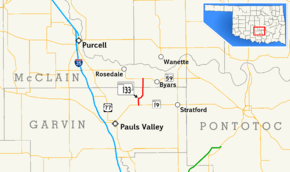
SH-133's southern terminus is at SH-19 seven miles (11 km) northeast of Pauls Valley.[4] The highway begins in Garvin County and crosses into McClain County 2.55 miles (4.10 km) north of SH-19.[1] The highway ends two miles (3.2 km) north of the county line at SH-59 between Rosedale and Byars.[2]

History
SH-133 first appeared on the 1959 state highway map,[3] implying it was commissioned in either late 1958 or early 1959. Originally, the route was entirely gravel-surfaced[3] but by 1963 the Garvin County portion had been paved.[5] The road was entirely paved in 1972.[6]
Junction list
| County | Location | mi[1][2] | km | Destinations | Notes |
|---|---|---|---|---|---|
| Garvin | | 0.00 | 0.00 | Southern terminus | |
| McClain | | 6.55 | 10.54 | Northern terminus | |
| 1.000 mi = 1.609 km; 1.000 km = 0.621 mi | |||||
References
- 1 2 3 4 Oklahoma Department of Transportation (2010-01-01). Control Section Maps: Garvin County (PDF) (Map) (2010–2011 ed.). Scale not given. Oklahoma City: Oklahoma Department of Transportation. Retrieved October 22, 2012.
- 1 2 3 4 Oklahoma Department of Transportation (2010-01-01). Control Section Maps: McClain County (PDF) (Map) (2010–2011 ed.). Scale not given. Oklahoma City: Oklahoma Department of Transportation. Retrieved October 22, 2012.
- 1 2 3 Oklahoma Road Map (PDF) (Map) (1959 ed.). Oklahoma Department of Highways. Retrieved November 1, 2007.
- ↑ Oklahoma Department of Transportation. Oklahoma Official State Map. 2005-2006 edition, second printing.
- ↑ Oklahoma Road Map (PDF) (Map) (1963 ed.). Oklahoma Department of Highways. Retrieved November 1, 2007.
- ↑ Official State Highway Map (PDF) (Map) (1973 ed.). Oklahoma Department of Highways. Retrieved November 1, 2007.