Okhla
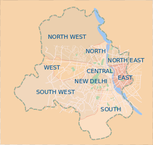
Okhla is a Suburban colony in South Delhi district located at Delhi border. It is more commonly known as Okhla Industrial Area (OIA) or Okhla Industrial Estate, an industrial suburb in South Delhi which is mainly divided into three Phases. Okhla has lent its name to the nearby planned township of NOIDA (New Okhla Industrial Development Area).
About
Okhla is among one of the oldest villages in Delhi near the bank of Yamuna river. This can be judged from the making of Okhla canal (Agra Canal) by Britrishers in 1874, presently known as Okhla Head. It is a small village. Now people from various corners of the nation constructed mostly unauthorized buildings by encroachment of Yamuna. Other than Okhla village which is nowadays not known by many people because of its smaller size as compared to others colonies surrounding it like Okhla Vihar, Jamia, Johri Farm, Abul Fazal etc.
History
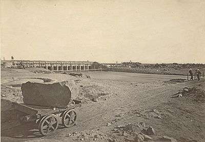
The Okhla barrage, which was developed by Britishers, is also the starting point of the Agra Canal built in 1874, today it is also the location of the Okhla Sanctuary, and further down the canal towards Agra, the Keetham Lake, National Bird Sanctuary. OKHLA is an acronym for Old Kanal Housing & Land Authority. K for Canal was used since CH would have a different sound. Template:CITATION NEEDED
The present campus of Jamia Millia Islamia university was established here in 1925. The Okhla Mandi is an important wholesale markets in Delhi, NSIC, IIIT Delhi, Govind Ballabh Pant Engineering College, Meera Bai Institute of Technology, Kalkaji Temple, Lotus Temple, Okhla vihar, Okhla Railway Station, Surya Hotel, C.C and the Okhla Water Works.
Okhla Industrial Estate
Okhla Industrial Estate, an industrial suburb of New Delhi in South Delhi was established by National Small Industries Corporation and was one of the 12 such estates being developed across India to encourage small industries. Construction work at the site began in 1952 and it was finally inaugurated in 1958,[1][2] and in time became synonymous to growth of small scale industries in region. Today it is divided in three phases.[3] The Okhla village became an important theatre centre of Delhi in 1950s, when veteran theater director, started establish "Okhla Theatre" here, using many local artists as actors, starting longing tradition of theater here.
Extension of Okhla
Apart from Industrial Estate, Okhla also has an extension of residential area which includes Zakir Nagar, Batla House, Jogabai and Jogabai Extension, Abul Fazal Enclave, Okhla Head, Jamia Nagar, Shaheen Bagh, Okhla Vihar, Johri Farm, Noor Nagar, Gaffar Manzil etc and includes the colonies situated on the bank of river Yamuna.
Phases
- Okhla Industrial Phase I and Phase II is one of the 28 notified industrial areas of Delhi, as per the Master Plan of 2001. And revenue earners from this base include ready-made garment exporters and leather garment exporters, besides other segments of industry such as pharmaceutical manufacturing units, plastic and packaging industries, printing presses, machinery manufacturers, call center, MNCs Office, Bank and others
- Okhla Industrial Estate Ph 3
The Okhla Industrial Estate or Phase III spreads over 110 acres (0.45 km2) and is a modest industrial beginning laid out British architect Mr Walter George, also famous for the planning and construction of Parliament House, North and South Blocks.
Today, there are a host of MNCs, Call center, BPO, Showrooms and Media Group operations in the area.
Overview
The whole industrial area is named after the main area Okhla Village, in South Delhi, with nearby areas now as its own parts like Batla House, Okhla Vihar, Zakir Nagar, Zakir Bagh, Jamia Nagar, Abul Fazal Enclave, Shaheen Bagh, Kalindi Colony, and Kalindi Kunj.
The Okhla area has a high density of Muslim population areas of Delhi, and show high linguistic literacy rate.[4] It is a state assembly constituency part of the South Delhi Lok Sabha constituency constituency.
Neighborhoods
East of Kailash, New Friends Colony, Nehru Place, Kalkaji, Abul Fazal Enclave, Sukhdev Vihar, Greater Kailash, Govindpuri, Sriniwaspuri, Tuglakabad, Sarita Vihar, Jasola, Shaheen Bagh, Jaitpur, Madanpur, Badarpur, Zakir Nagar, Okhla Vihar, Ghaffar Manzil Colony, hazi colony, Batla House and Harkesh Nagar (a village attached with Okhla Phase 2 & 3).
Wildlife Sanctuaries
- Okhla Sanctuary, a Bird Park and Wildlife Sanctuary, where during the month of September thousands of migratory birds including shovellers, pintail, common teal, gadwall and blue winged teal visit the area and is ideal for nature lovers.
Hospitals
Hospitals in the area include Indraprastha Apollo Hospital and Escort Heart Hospital, Al-shifa Multi Speciality Hospital, Holy Family Hospital, M.A Ansari Health Center.
Education
Institute in the area include Sayeed Education Centre(the institute of mathematics)
Public Gardens
1. Kalindi Kunj,Okhla Head is the most famous public garden close to the river of Yamuna. The main attractions are the fountains adorned with colorful lights. A large number of tourists arrive in the evening to enjoy the scenic view of the fountains. Delhi Ride Park also open in kalindi kunj park (also known as 9 Number Park)
2. Ashoka Park adjacent to Zakir Nagar near New Friends Colony.
3. Tikona Park near SBI Bank, Zakir Nagar.
4. Tikona Park near Batla House main road.
Transport
It is well connected by road and rail and is not far from the airport, as it is located in the centre of the National Capital Territory. Business districts such as Nehru Place and Connaught Place are not far and even the inland container terminal of the Container Corporation of India is also close at hand.
By the end of September 2010, Okhla is also getting connected to the Delhi Metro Network. The okhla metro station on the Violet Line (Delhi Metro) is upcoming near Harkesh Nagar in Phase-II. In 2014 Main Okhla will connects with Delhi Metro Rail. These Station will be Jamia Nagar, Okhla Vihar (Abul Fazal Enclave), Jasola and Kalindi Kunj.a Amir Rizwan rode
Real estate
The entire Industrial Area Phase-1,2 and 3 allotted by DDA, DSIDC and Directorate of Industries, this area known for Industrial establishments however In result private builders and Govt real estate company NBCC as well DLF, involve in to the vicinity their commercial and hotel project in the Area, being a prime locality of South Delhi most economical place in the capital Indian business houses as well MNCs and investor have interest in this vicinity, two Metro station connectivity and underpass connected Mathura Road become a strong point for locality. due to small and medium size industrial and commercial establishments and great connectivity by bus as well as metro it attracts both medium entrepreneurs and corporate.
Further reading
- Ram, Paras (1967). A study of the export potential of Okhla industrial estate. Indian Institute of Foreign Trade.
See also
References
- ↑ Jain, L. C. (1998). The city of hope: the Faridabad story. Concept Publishing Company. p. 100. ISBN 81-7022-748-8.
- ↑ Prasad, Rajendra (1995). Dr. Rajendra Prasad, Correspondence and Select Documents, Vol. 6. Allied Publishers. ISBN 81-7023-002-0.
March 21, 1958
- ↑ Bandyopadhyaya, Kalyani (1969). Industrialization through industrial estates: a pattern of economic decentralization. Bookland. p. 94.
- ↑ Ahmad, Aijazuddin; Hamdard Education Society (1993). Muslims in India: National capital territory of Delhi. Inter-India Publications. pp. 111–112. ISBN 81-210-0346-6.
Template:Sonipat
Coordinates: 28°34′N 77°17′E / 28.567°N 77.283°E