Oita Airport
| Oita Airport 大分空港 | |||||||||||
|---|---|---|---|---|---|---|---|---|---|---|---|
|
Oita Airport | |||||||||||
| IATA: OIT – ICAO: RJFO | |||||||||||
| Summary | |||||||||||
| Airport type | Public | ||||||||||
| Serves | Ōita | ||||||||||
| Elevation AMSL | 17 ft / 5 m | ||||||||||
| Coordinates | 33°28′46″N 131°44′14″E / 33.47944°N 131.73722°ECoordinates: 33°28′46″N 131°44′14″E / 33.47944°N 131.73722°E | ||||||||||
| Website | http://www.oita-airport.jp/en/ | ||||||||||
| Map | |||||||||||
 RJFO Location in Japan | |||||||||||
| Runways | |||||||||||
| |||||||||||
| Statistics (2014) | |||||||||||
| |||||||||||
.jpg)
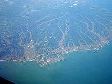
Oita Airport seen from the air
Oita Airport (大分空港 Ōita Kūkō) (IATA: OIT, ICAO: RJFO) is an airport in Kunisaki, Ōita, Japan, 16 NM (30 km; 18 mi) northeast[1] of Ōita.
The airport is accessible by bus but not by train.[3] Hovercraft service to Oita was available[4] until 2009, it was the last hovercraft service in Japan.
Airlines and destinations
| Airlines | Destinations |
|---|---|
| All Nippon Airways | Tokyo-Haneda |
| ANA operated by ANA Wings | Nagoya-Centrair, Osaka-Itami |
| Japan Airlines | Tokyo-Haneda |
| Japan Airlines operated by J-Air | Osaka-Itami |
| Jetstar Japan | Tokyo-Narita, Osaka-Kansai |
| Korean Air | Seoul-Incheon[5] |
| Mandarin Airlines | Charter: Taichung[6] |
| Solaseed Air | Tokyo-Haneda |
| T'way Air | Seoul-Incheon[7] |
References
- 1 2 AIS Japan
- ↑ "Oita Airport Statistics" (PDF) (Press release). Osaka Ministry of Land, Infrastructure and Transport Civil Aviation Bureau. Retrieved 8 July 2016.
- ↑ http://www.oita-airport.jp/access/
- ↑ http://oita-hover.main.jp/
- ↑ http://airlineroute.net/2014/09/22/ke-oit-jan15/
- ↑ "Mandarin Airlines Reschedules Taichung – Oita Launch to Sep 2016". routesonline. Retrieved 17 June 2016.
- ↑ http://airlineroute.net/2014/09/10/tw-oit-sep14/
1 Joint civil-military use | |||||||||||
| Major hubs | |||||||||||
| International |
| ||||||||||
| Domestic |
| ||||||||||
| General aviation |
| ||||||||||
| Military | |||||||||||
| Heliports |
| ||||||||||
| Defunct | |||||||||||
This article is issued from Wikipedia - version of the 12/4/2016. The text is available under the Creative Commons Attribution/Share Alike but additional terms may apply for the media files.