Ohio State Route 513
| ||||
|---|---|---|---|---|
 | ||||
| Route information | ||||
| Maintained by ODOT | ||||
| Length: | 27.26 mi[1] (43.87 km) | |||
| Existed: | 1937 – present | |||
| Major junctions | ||||
| South end: |
| |||
|
| ||||
| North end: |
| |||
| Location | ||||
| Counties: | Noble, Guernsey | |||
| Highway system | ||||
| ||||

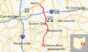
State Route 513 (SR 513) is a north–south state highway in the eastern portion of Ohio, a U.S. state. The southern terminus of State Route 513 is at State Route 146 in Summerfield. Its northern terminus is at a T-intersection with U.S. Route 22 approximately 11 miles (18 km) northwest of Fairview.
Route description
This state highway passes through the northeastern quadrant of Noble County and the eastern portion of Guernsey County. State Route 513 is not included as a part of the National Highway System.[2]
History
State Route 513 first appeared in 1937 along the alignment that it currently follows between State Route 146 and U.S. Route 22. It has not experienced any major changes in its routing since its inception.[3][4]
Major intersections
| County | Location | mi[1] | km | Destinations | Notes |
|---|---|---|---|---|---|
| Noble | Summerfield | 0.00 | 0.00 | ||
| Batesville | 9.38 | 15.10 | Southern end of SR 147 concurrency | ||
| 9.46 | 15.22 | Northern end of SR 147 concurrency | |||
| Guernsey | Quaker City | 14.34 | 23.08 | ||
| Oxford Township | 21.16 | 34.05 | Exit 193 (I-70) | ||
| Madison Township | 27.26 | 43.87 | |||
1.000 mi = 1.609 km; 1.000 km = 0.621 mi
| |||||
References
- 1 2 Ohio Department of Transportation. "Technical Services Straight Line Diagrams". Retrieved 2010-11-12.
- ↑ National Highway System: Ohio (PDF) (Map). Federal Highway Administration. December 2003. Retrieved 2010-11-12.
- ↑ Ohio State Map (Map). Ohio Department of Transportation. 1936.
- ↑ Ohio State Map (Map). Ohio Department of Transportation. 1937.
External links
This article is issued from Wikipedia - version of the 12/3/2015. The text is available under the Creative Commons Attribution/Share Alike but additional terms may apply for the media files.