Oguni Jinja
| Okuni Jinja 小國神社 | |
|---|---|
|
| |
| Information | |
| Dedicated to | Ōnamuchi-no-mikoto |
| Address | 3956-1 Mori-machi, Shūchi District, Shizuoka |
| Website |
www |
|
| |
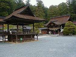
The Okuni Shrine (小國神社 Okuni jinja), also known as Okuni jinja, is a Japanese Shinto shrine in the town of Mori, in Shizuoka Prefecture.[1]
Enshrined kami
The primary kami of Okuni Jinja is the Ōkuninushi (Ōnamuchi-no-mikoto 大己貴命).[1] There are numerous small subsidiary shrines to various kami within the shrine grounds.
History
The date of Okuni Shrine’s foundation is unknown. Shrine tradition gives a date of February 18, 555 (during the reign of Emperor Kinmei as the date when a shrine was first constructed on the 511-meter Mount Hongū, which now forms part of the shrine’s grounds. The shrine appears in historical records in an entry within the Shoku Nihon Kōki dated June 14, 884 and it is mentioned again in the Engishiki records.
It has been styled the ichinomiya of Tōtōmi Province since at least 1235, and continued to be referred to as the “Ichinomiya” until the end of the Edo period. Takeda Shingen worshipped at the shrine in 1572, and Tokugawa Ieyasu in 1575. Ieyasu later contributed to the rebuilding of the Honden, and subsequent generations of Tokugawa Shogun continued to support the shrine. Okuni is one of two shrines claiming to hold the title of ichinomiya of former Tōtōmi Province.[2]
After the Meiji Restoration, it was proclaimed a prefectural shrine (県社) in 1873. In the system of ranked Shinto shrines, Okuni was listed in 1875 among the 3rd class of nationally significant shrines or Kokuhei Shōsha (国幣小社).[3]
Events
The main festival of the shrine is held annually on April 18, during which time a set of twelve dances are performed. This performance is said to date to the early Heian period and is a National Intangible Cultural Property.
See also
References
- 1 2 Kotodamaya.com, "Okuni Jinja"; retrieved 2013-1-27.
- ↑ "Nationwide List of Ichinomiya," p. 1; retrieved 2013-1-27.
- ↑ Ponsonby-Fane, Richard. (1959). The Imperial House of Japan, pp. 125.
Coordinates: 34°50′51″N 137°53′57″E / 34.84750°N 137.89917°E