Ogooué River
| Ogooué | |
|---|---|
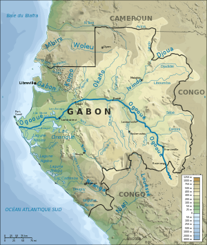 The Ogooué watershed | |
| Country | Gabon |
| Basin | |
| Main source | Kengue, Republic of the Congo |
| River mouth | Port Gentil, Gabon |
| Basin size | 223,856 km2 (86,431 sq mi) |
| Physical characteristics | |
| Length | 1,200 km (750 mi) |
| Discharge |
|
The Ogooué (or Ogowe), some 1,200 kilometres (700 mi) long, is the principal river of Gabon in west central Africa and the fourth largest river in Africa by volume of discharge, trailing only the Congo, Niger and Zambezi. Its watershed drains nearly the entire country of Gabon, with some tributaries reaching into the Republic of the Congo, Cameroon, and Equatorial Guinea.
Course
The Ogooué River rises in the northwest of the Bateke Plateaux near Kengue, Republic of Congo. It runs northwest, and enters Gabon near Boumango. Poubara Falls are near Maulongo. From Lastoursville until Ndjole, the Ogooué is non-navigable due to rapids. From the latter city, it runs west, and enters the Gulf of Guinea near Ozouri, south of Port Gentil. The Ogowe Delta is quite large, about 100 km long and 100 km wide.
Basin
The Ogooué Basin is 223,856 square kilometres (86,000 sq mi), of which 173,000 square kilometres (67,000 sq mi) or 73 percent lies within Gabon. It mostly consists of undisturbed rainforest with some savanna grassland where the mid-year dry season is longest. It is home to a high biodiversity. All three species of African crocodile, for instance, occur in the river: the Nile crocodile, the dwarf crocodile, and the slender-snouted crocodile. It is also the type locality for the catfish Synodontis acanthoperca.[1]
The Mpassa River is a tributary of the Ogooué River. The Ndjoumou River is the main tributary of Mpassa River.
Economy
The Ogooué is navigable from Ndjole to the sea. It is used to bring wood to the Port Gentil Harbour.
The Ogowe Basin includes several major conservation reverves, notably Lope National Park.
The catchment area has an average population density of 4 people per km². Towns along the river include Ayem, Adané, Loanda, Lambaréné, Ndjole, Booué, Kankan, Maulongo, Mboungou-Mbadouma, Ndoro, Lastoursville, Moanda, and Franceville near the Congo border.
Towns in Congo include Zanaga.
The first European explorer, Pierre Savorgnan de Brazza, traveled in the area in the 1870s. Persistent reports by the natives of creatures resembling dinosaurs have motivated a number of recent expeditions into the area of the northern tributaries of the Ogooué and the swamps on the western side of the Congo River.
Tributaries

The Ogowe River receives water of numerous tributaries including:
- Abanga, which rises in the Cristal Mountains, near Medouneu
- Baniaka
- Dilo
- Iyinda, the most important tributary
- Letili
- Lassio
- Lebombi
- Lekabi
- Lekedi
- Lekoni, which flows across Akieni and Leconi
- Letili
- Leyou
- Lolo
- Mbine
- Ngolo
- Ngounie
- Nke
- Offoue
- Okano, whose main tributary is the Lara River
- Mpassa, which flows across Franceville
- Sebe, which flows past Okondja
- Wagny
References
- ↑ Froese, Rainer and Pauly, Daniel, eds. (2013). "Synodontis acanthoperca" in FishBase. March 2013 version.
- Perusset André. 1983. Oro-Hydrographie (Le Relief) in Geographie et Cartographie du Gabon, Atlas Illustré led by The Ministère de l'Education Nationale de la Republique Gabonaise. Pg 10-13. Paris, France: Edicef.
- Petringa, Maria. Brazza, A Life for Africa. Bloomington, IN: AuthorHouse, 2006. ISBN 9781-4259-11980. Describes Pierre Savorgnan de Brazza's extensive explorations of the Ogoué River basin.
- National Geographic. 2003. African Adventure Atlas Pg 24,72. led by Sean Fraser.
- Gardinier David. 1994. Historical Dictionary of Gabon 2nd Edition. USA: The Scarercrow Press, Inc.
- Direction General de L'Environnement.1999. Stratégie nationale et Plan D'action sur la biodiversité biologique du Gabon.
- The Atlas of Africa. Pg 201. by Regine Van Chi-Bonnardel. Jeune Afrique Editions.
- Lerique Jacques. 1983. Hydrographie-Hydrologie. in Geographie et Cartographie du Gabon, Atlas Illustré led by The Ministère de l'Education Nationale de la Republique Gabonaise. Pg 14-15. Paris, France: Edicef.
External links
| Wikisource has the text of The New Student's Reference Work article Ogowe. |
- World Resources Institute map of Ogooué watershed
- Map of the Ogoué River basin at Water Resources eAtlas
- Maria Petringa's 1997 "Pierre Savorgnan de Brazza: Brief Life of a Lover of Africa" about Brazza's extensive explorations of the Ogoué River basin
- Website about the dinosaur hunt
Coordinates: 2°40′S 14°30′E / 2.667°S 14.500°E