Offerle, Kansas
| Offerle, Kansas | |
|---|---|
| City | |
 Location within County and Kansas | |
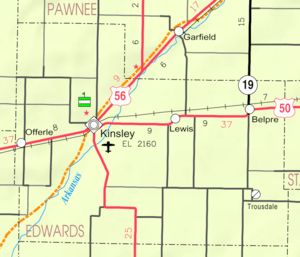 KDOT map of Edwards County (legend) | |
| Coordinates: 37°53′28″N 99°33′35″W / 37.89111°N 99.55972°WCoordinates: 37°53′28″N 99°33′35″W / 37.89111°N 99.55972°W | |
| Country | United States |
| State | Kansas |
| County | Edwards |
| Government | |
| • Type | Mayor–Council |
| Area[1] | |
| • Total | 0.26 sq mi (0.67 km2) |
| • Land | 0.26 sq mi (0.67 km2) |
| • Water | 0 sq mi (0 km2) |
| Elevation | 2,270 ft (692 m) |
| Population (2010)[2] | |
| • Total | 199 |
| • Estimate (2015)[3] | 196 |
| • Density | 770/sq mi (300/km2) |
| Time zone | Central (CST) (UTC-6) |
| • Summer (DST) | CDT (UTC-5) |
| ZIP code | 67563 |
| Area code(s) | 620 |
| FIPS code | 20-52200 [4] |
| GNIS feature ID | 0473539 [5] |
Offerle is a city in Edwards County, Kansas, United States. As of the 2010 census, the city population was 199.[6]
History
Offerle was founded in 1876. It was named for Lawrence Offerle, one of its founders.[7]
The first post office in Offerle was established in May, 1876.[8]
Geography
Offerle is located at 37°53′28″N 99°33′35″W / 37.89111°N 99.55972°W (37.891067, -99.559646).[9] According to the United States Census Bureau, the city has a total area of 0.26 square miles (0.67 km2), all of it land.[1]
Climate
The climate in this area is characterized by hot, humid summers and generally mild to cool winters. According to the Köppen Climate Classification system, Offerle has a humid subtropical climate, abbreviated "Cfa" on climate maps.[10]
Demographics
| Historical population | |||
|---|---|---|---|
| Census | Pop. | %± | |
| 1920 | 225 | — | |
| 1930 | 298 | 32.4% | |
| 1940 | 273 | −8.4% | |
| 1950 | 269 | −1.5% | |
| 1960 | 208 | −22.7% | |
| 1970 | 212 | 1.9% | |
| 1980 | 244 | 15.1% | |
| 1990 | 228 | −6.6% | |
| 2000 | 220 | −3.5% | |
| 2010 | 199 | −9.5% | |
| Est. 2015 | 196 | [3] | −1.5% |
| U.S. Decennial Census | |||
2010 census
As of the census[2] of 2010, there were 199 people, 83 households, and 58 families residing in the city. The population density was 765.4 inhabitants per square mile (295.5/km2). There were 92 housing units at an average density of 353.8 per square mile (136.6/km2). The racial makeup of the city was 91.5% White, 3.0% Native American, and 5.5% from other races. Hispanic or Latino of any race were 13.6% of the population.
There were 83 households of which 27.7% had children under the age of 18 living with them, 65.1% were married couples living together, 1.2% had a female householder with no husband present, 3.6% had a male householder with no wife present, and 30.1% were non-families. 25.3% of all households were made up of individuals and 10.8% had someone living alone who was 65 years of age or older. The average household size was 2.40 and the average family size was 2.91.
The median age in the city was 43.4 years. 23.6% of residents were under the age of 18; 4.9% were between the ages of 18 and 24; 23.5% were from 25 to 44; 30.5% were from 45 to 64; and 17.1% were 65 years of age or older. The gender makeup of the city was 45.2% male and 54.8% female.
2000 census
As of the census[4] of 2000, there were 220 people, 86 households, and 65 families residing in the city. The population density was 818.2 people per square mile (314.6/km²). There were 90 housing units at an average density of 334.7 per square mile (128.7/km²). The racial makeup of the city was 99.09% White, 0.45% from other races, and 0.45% from two or more races. Hispanic or Latino of any race were 2.27% of the population.
There were 86 households out of which 27.9% had children under the age of 18 living with them, 68.6% were married couples living together, 3.5% had a female householder with no husband present, and 24.4% were non-families. 23.3% of all households were made up of individuals and 12.8% had someone living alone who was 65 years of age or older. The average household size was 2.56 and the average family size was 3.03.
In the city the population was spread out with 24.1% under the age of 18, 9.5% from 18 to 24, 26.8% from 25 to 44, 20.9% from 45 to 64, and 18.6% who were 65 years of age or older. The median age was 40 years. For every 100 females there were 107.5 males. For every 100 females age 18 and over, there were 103.7 males.
The median income for a household in the city was $40,208, and the median income for a family was $41,250. Males had a median income of $30,313 versus $23,125 for females. The per capita income for the city was $14,549. About 3.6% of families and 7.6% of the population were below the poverty line, including 15.6% of those under the age of eighteen and 9.1% of those sixty five or over.
References
- 1 2 "US Gazetteer files 2010". United States Census Bureau. Archived from the original on January 24, 2012. Retrieved 2012-07-06.
- 1 2 "American FactFinder". United States Census Bureau. Retrieved 2012-07-06.
- 1 2 "Annual Estimates of the Resident Population for Incorporated Places: April 1, 2010 to July 1, 2015". Retrieved July 2, 2016.
- 1 2 "American FactFinder". United States Census Bureau. Archived from the original on September 11, 2013. Retrieved 2008-01-31.
- ↑ "US Board on Geographic Names". United States Geological Survey. 2007-10-25. Retrieved 2008-01-31.
- ↑ "2010 City Population and Housing Occupancy Status". U.S. Census Bureau. Archived from the original on July 21, 2011. Retrieved September 15, 2011.
- ↑ Kansas State Historical Society (1916). Biennial Report of the Board of Directors of the Kansas State Historical Society. Kansas State Printing Plant. p. 184.
- ↑ "Kansas Post Offices, 1828-1961 (archived)". Kansas Historical Society. Archived from the original on October 9, 2013. Retrieved 8 June 2014.
- ↑ "US Gazetteer files: 2010, 2000, and 1990". United States Census Bureau. 2011-02-12. Retrieved 2011-04-23.
- ↑ Climate Summary for Offerle, Kansas
External links
| Wikimedia Commons has media related to Offerle, Kansas. |
- City
- Schools
- USD 347, local school district
- Businesses
- Maps
- Offerle City Map, EdwardsCounty.org
- Offerle City Map, KDOT
Municipalities and communities of Edwards County, Kansas, United States | ||
|---|---|---|
| Cities | 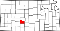 | |
| Unincorporated communities | ||
| Townships | ||