Oberhavel
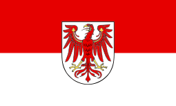
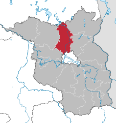
Oberhavel is a Kreis (district) in the northern part of Brandenburg, Germany. Its neighbouring districts are (clockwise from the north): Mecklenburg-Strelitz in Mecklenburg-Western Pomerania, the districts of Uckermark and Barnim, the Bundesland of Berlin, and the districts of Havelland and Ostprignitz-Ruppin.
Geography
The district is located on the upper course of the Havel river from its source to the outskirts of Berlin. The north is characterised by many lakes including the Großer Stechlinsee, which is well known thanks to a novel by Theodor Fontane called Der Stechlin.
History
The district was created on 6 December 1993 through the merging of the old Gransee and Oranienburg districts.
Coat of arms
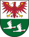 |
The coat of arms shows the eagle as the symbol of Brandenburg in the upper part. In the lower half are two flying swans on green background representing nature with many lakes. The coat of arms was unofficially used by the precursor district of Oranienburg before the merger, but was never officially granted. It was granted to the district of Oberhavel on 18 May 1994. |
Towns and municipalities
Demography
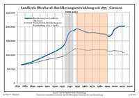
Development of Population since 1875 within the Current Boundaries (Blue Line: Population; Dotted Line: Comparison to Population Development of Brandenburg state; Grey Background: Time of Nazi rule; Red Background: Time of Communist rule)
Recent Population Development (Blue Line) and Forecasts
Landkreis Oberhavel:
Population development within the current boundaries[2]
| Year |
Population |
|
|
|---|
| 1875 | 64 084 |
| 1890 | 75 767 |
| 1910 | 99 395 |
| 1925 | 119 031 |
| 1933 | 138 026 |
| 1939 | 178 595 |
| 1946 | 187 548 |
| 1950 | 192 989 |
| 1964 | 179 515 |
| 1971 | 180 152 |
|
|
| Year |
Population |
|
|
|---|
| 1981 | 173 027 |
| 1985 | 174 522 |
| 1989 | 172 119 |
| 1990 | 169 086 |
| 1991 | 167 015 |
| 1992 | 165 764 |
| 1993 | 166 214 |
| 1994 | 167 935 |
| 1995 | 170 505 |
| 1996 | 173 666 |
|
|
| Year |
Population |
|
|
|---|
| 1997 | 178 353 |
| 1998 | 183 997 |
| 1999 | 189 191 |
| 2000 | 192 123 |
| 2001 | 194 022 |
| 2002 | 195 399 |
| 2003 | 197 055 |
| 2004 | 198 550 |
| 2005 | 200 184 |
| 2006 | 201 289 |
|
|
| Year |
Population |
|
|
|---|
| 2007 | 201 945 |
| 2008 | 202 231 |
| 2009 | 202 776 |
| 2010 | 203 124 |
| 2011 | 201 199 |
| 2012 | 202 162 |
|
|
Detailed data sources are to be found in the Wikimedia Commons.[3]
Sport
The district is home to three rugby union clubs, the RU Hohen Neuendorf, Veltener RC and Stahl Hennigsdorf Rugby. The latter was the most successful rugby club in East Germany, winning 27 national championships from 1952 to 1990.[4]
References
External links
 Media related to Oberhavel at Wikimedia Commons
 Urban and rural districts in the state of Brandenburg in Germany  |
|---|
|
| Urban districts | |
|---|
|
| Rural districts | |
|---|
Coordinates: 52°53′N 13°15′E / 52.883°N 13.250°E / 52.883; 13.250
 Development of Population since 1875 within the Current Boundaries (Blue Line: Population; Dotted Line: Comparison to Population Development of Brandenburg state; Grey Background: Time of Nazi rule; Red Background: Time of Communist rule)
 Recent Population Development (Blue Line) and Forecasts