Oberhausen an der Nahe
| Oberhausen an der Nahe | ||
|---|---|---|
| ||
 Oberhausen an der Nahe | ||
Location of Oberhausen an der Nahe within Bad Kreuznach district  | ||
| Coordinates: 49°47′35″N 7°45′30″E / 49.79306°N 7.75833°ECoordinates: 49°47′35″N 7°45′30″E / 49.79306°N 7.75833°E | ||
| Country | Germany | |
| State | Rhineland-Palatinate | |
| District | Bad Kreuznach | |
| Municipal assoc. | Bad Münster am Stein-Ebernburg | |
| Government | ||
| • Mayor | Horst Schmitt (acting) | |
| Area | ||
| • Total | 3.31 km2 (1.28 sq mi) | |
| Population (2015-12-31)[1] | ||
| • Total | 374 | |
| • Density | 110/km2 (290/sq mi) | |
| Time zone | CET/CEST (UTC+1/+2) | |
| Postal codes | 55585 | |
| Dialling codes | 06755 | |
| Vehicle registration | KH | |
| Website | www.oberhausen-nahe.de | |

Oberhausen an der Nahe is an Ortsgemeinde – a municipality belonging to a Verbandsgemeinde, a kind of collective municipality – in the Bad Kreuznach district in Rhineland-Palatinate, Germany. It belongs to the Verbandsgemeinde of Bad Münster am Stein-Ebernburg, whose seat is in the like-named town. Oberhausen is a winegrowing village. Oberhausen an der Nahe is one of two municipalities in the district with the name Oberhausen. The other is Oberhausen bei Kirn.
Geography
Location

Oberhausen lies on the River Nahe at the foot of the Lemberg, the Middle Nahe's highest hill.
Neighbouring municipalities
Clockwise from the north, Oberhausen an der Nahe’s neighbours are the municipalities of Schloßböckelheim, Niederhausen, Feilbingert, Hallgarten (although this boundary is very short), Duchroth and Waldböckelheim, all of which likewise lie within the Bad Kreuznach district.
History
In 1937, an ancient Roman estate was discovered at the Buchwald (forest). On the Lemberg was a Roman signalling station that relayed messages between camps at Kreuznach and Metz. Oberhausen itself (formerly called Husen) was founded in Merovingian times (5th to 8th centuries) and was within Disibodenberg Abbey’s sphere of influence. At the time of the partition of the Nahegau, the village passed in 1200 to the Counts Palatine of Zweibrücken, who enfeoffed the Knights of Montfort with it in 1274. Until 1700, Oberhausen was jointly held by the Houses of Boos zu Waldeck, Blick von Lichtenberg, Albrecht von Günterode and the Dukes of Zweibrücken-Veldenz. From 1789 to 1814, the village, along with all the German lands on the Rhine’s left bank, were ruled by Revolutionary and later Napoleonic France. After the Congress of Vienna, Oberhausen belonged as of 1814 to the Kingdom of Bavaria, and it remained in Bavaria through that state’s transition into a constituent kingdom of the German Empire (1879) and the Free State after the Revolution, in the Weimar Republic (1919) and the Third Reich (1933) until the end of the Second World War (1945), after which it became part of the then newly founded state of Rhineland-Palatinate in 1949, upon the creation of what is now known as the Bonn Republic. In the course of administrative restructuring in Rhineland-Palatinate, Oberhausen was transferred out of the now dissolved Rockenhausen district and into the Bad Kreuznach district. From an ecclesiastical standpoint, Oberhausen still belongs to the Evangelical Church of the Palatinate (Evangelical) and the Roman Catholic Diocese of Speyer.[2]
Population development
Oberhausen’s population development since the Third Reich is shown in the table below. The figures for the years up to 1987 are drawn from census data:[3]
| Year | Inhabitants |
| 1939 | 348 |
| 1950 | 370 |
| 1961 | 395 |
| 1970 | 364 |
| 1987 | 389 |
| 2005 | 423 |
Religion
As at 30 November 2013, there are 379 full-time residents in Oberhausen, and of those, 206 are Evangelical (54.354%), 89 are Catholic (23.483%), 2 are Russian Orthodox (0.528%), 10 (2.639%) belong to other religious groups and 72 (18.997%) either have no religion or will not reveal their religious affiliation.[4]
Politics
Municipal council
The council is made up of 8 council members, who were elected by majority vote at the municipal election held on 7 June 2009, and the honorary mayor as chairman.
Mayor
At the time of Oberhausen’s last mayoral election, the winner was Klaus Matzenbacher, but for reasons that have not been clearly published, he has since left office, and the mayor’s official functions are currently being performed by the first deputy. Since 1 June 2013, this has been Horst Schmitt. Before that date, it was Claudia Stein-Hammer, who is no longer on council, apparently after having moved from the village. The second deputy (effectively the first deputy) is Manfred Kehrein.[5][6]
Coat of arms
The German blazon reads: Von Schwarz über Silber geteilt, oben ein rotgekrönter und rotbewehrter, wachsender goldener Löwe, unten drei schrägrechts aneinandergereihte rautenförmige blaue Schnallen.
The municipality’s arms might in English heraldic language be described thus: Per fess sable a demilion Or armed, langed and crowned gules and argent three arming buckles conjoined in bend azure.
The charges in the arms are references to the village’s past lords and overlords. The lion in the upper field represents Electoral Palatinate while the three buckles in the lower field represent the Lords Boos zu (at) Waldeck.[7]
Culture and sightseeing
Buildings
The following are listed buildings or sites in Rhineland-Palatinate’s Directory of Cultural Monuments:[8]
- Protestant church, Kirchgasse 4 – Gothic Revival sandstone-block building, 1865–1868; warriors’ memorial 1914-1918
- Bahnhofstraße, graveyard – graveyard cross, cast-iron, possibly from the latter half of the 19th century
- Hallgartener Straße 3 – former Mühle Bollenbach (mill); three-sided estate; sandstone-block building, marked 1866
- Hallgartener Straße 5 – former Mühle Stein (mill); long Late Baroque building, partly timber-frame, barn, from the latter half of the 18th century
- Hauptstraße – barn with oven
- Untere Kirchgasse 1 – Baroque timber-frame house, partly solid, marked 1669
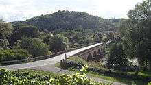
- Luitpold-Brücke (bridge), north of the village – six-arch bridge across the Nahe, sandstone-block, 1889, Regional Building Superintendent N. Emrich, Kirchheimbolanden
The Luitpold Bridge’s dedication reads:[9]
- LVITPOLD-BRV̈CKE
- Erbaut unter der Regentschaft
- Seiner Koeniglichen Hoheit
- Prinz Luitpold von Bayern
- ANNO DOMINI
- 1889
The prince in question – and the bridge’s namesake – was Luitpold, Prince Regent of Bavaria, who had become Bavaria’s de facto ruler after his (by 1889, late) nephew “Mad” King Ludwig had been removed from power.
Clubs
The following clubs are active in Oberhausen an der Nahe:[10]
- Aktives Oberhausen
- Angelsportverein — angling club
- Freiwillige Feuerwehr Oberhausen — volunteer fire brigade
- TuS Duchroth Leichtathletik — gymnastic and sport club
Winegrowing

Oberhausen an der Nahe belongs to the Nahetal Winegrowing Area within the Nahe wine region. Eight winegrowing operations are active within the municipality, and the area planted with vineyards is 32 ha. Some 94% of the wine grown here is white wine varieties (as at 2007). In 1979, there were still 13 active winegrowing operations, and the area planted with vineyards was somewhat greater at 44 ha.[3] The following wineries (Weingüter) can be found in Oberhausen an der Nahe:[11]
- Weingut Christmann-Faller
- Weingut Dönnhoff
- Weingut Nessel
- Weingut Rech
- Weingut Staab
- Weingut Stein
- Weingut Weck
The Family Dönnhoff has been making wine in this region since 1750.[12] [13] [14]
Transport
Running through the village and across the Nahe on the Luitpold-Brücke (bridge) is Landesstraße 235, known within the village as Naheweinstraße, while the stretch beyond the bridge is called Hermannshöhle. Meeting this road in the village centre is Landesstraße 378, known within the village as Hallgartener Straße. Running through neighbouring Waldböckelheim to the northwest is Bundesstraße 41, which leads eastwards to Rüdesheim an der Nahe and the district seat, Bad Kreuznach, and thereafter to the Autobahn A 61 (Koblenz–Ludwigshafen) just beyond. In the other direction, Bundesstraße 41 leads to Bad Sobernheim, Kirn and eventually Idar-Oberstein. Serving nearby Norheim is a railway station on the Nahe Valley Railway (Bingen–Saarbrücken).
References
- ↑ "Gemeinden in Deutschland mit Bevölkerung am 31. Dezember 2015" (PDF). Statistisches Bundesamt (in German). 2016.
- ↑ History
- 1 2 Statistisches Landesamt Rheinland-Pfalz – Regionaldaten
- ↑ Religion
- ↑ Oberhausen’s council
- ↑ Notice of changeover
- ↑ Description and explanation of Oberhausen an der Nahe’s arms
- ↑ Directory of Cultural Monuments in Bad Kreuznach district
- ↑ Image of dedication
- ↑ Clubs
- ↑ Wineries
- ↑ Diel, Armin (2009). WeinGuide Deutschland 2009. Christian Verlag. p. 466. ISBN 978-3-88472-912-0.
- ↑ TheWineDoctor - Donnhoff
- ↑ Parker, Robert (2005). The World's Greatest Wine Estates. Simon & Schuster. p. 429. ISBN 978-0-7432-3771-0.
External links
| Wikimedia Commons has media related to Oberhausen an der Nahe. |
- Municipality’s official webpage (German)
- Oberhausen an der Nahe in the collective municipality’s webpages (German)