Oakwood, Georgia
| Oakwood, Georgia | |
|---|---|
| City | |
|
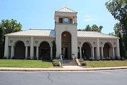
Oakwood City Hall | |
 Location in Hall County and the state of Georgia | |
| Coordinates: 34°13′52″N 83°52′57″W / 34.23111°N 83.88250°WCoordinates: 34°13′52″N 83°52′57″W / 34.23111°N 83.88250°W | |
| Country | United States |
| State | Georgia |
| County | Hall |
| Oakwood | 1896 |
| Government | |
| • Type | Popular Vote Democracy. |
| • Mayor | Lamar Scroggs |
| Area | |
| • Total | 3.1 sq mi (8.1 km2) |
| • Land | 3.1 sq mi (8.1 km2) |
| • Water | 0 sq mi (0 km2) |
| Elevation | 1,158 ft (353 m) |
| Population (2010) | |
| • Total | 3,970 |
| • Density | 867.4/sq mi (332/km2) |
| Time zone | Eastern Standard Time (EST) (UTC-5) |
| • Summer (DST) | EDT (UTC-4) |
| ZIP codes | 30566, 30542, 30502, 30504 |
| Area code(s) | 770 |
| FIPS code | 13-57260[1] |
| GNIS feature ID | 0319873[2] |
| Website |
www |
Oakwood is a city in Hall County, Georgia, United States. It is part of the Gainesville, GA Metropolitan Statistical Area. The population was 3,970 at the 2010 census. Oakwood is home to the University of North Georgia Gainesville Campus and Wayne Farms.
Geography
Oakwood is located at 34°13′52″N 83°52′57″W / 34.23111°N 83.88250°W (34.230976, −83.882364).[3]
According to the United States Census Bureau, the city has a total area of 3.1 square miles (8.0 km2), all of it land.
Oakwood acquired the unincorporated community of Chestnut Mountain (30502) in 2008 (The area uses a Flowery Branch ZIP code, yet is in the city limits of Oakwood) which borders Braselton.
Origin of name
Oakwood was named after the railroad tracks that ran, and still are running as of 2008, through both the City of Oakwood and Gainesville. Because most of the cars contained wood (particularly high quality oak), it seemed reasonable to name the city after that type of lumber.
Oakwood was initially called O'Dell's Crossing for its main landowner, Ulysses S. O'Dell Sr. The O'Dell home place was located only a few hundred feet from the railroad track. The name changed in 1896 because Southern Railway trains would stop on the way from Atlanta to Gainesville to get oak wood for their engines.
Demographics
| Historical population | |||
|---|---|---|---|
| Census | Pop. | %± | |
| 1910 | 110 | — | |
| 1920 | 163 | 48.2% | |
| 1930 | 189 | 16.0% | |
| 1940 | 207 | 9.5% | |
| 1950 | 225 | 8.7% | |
| 1960 | 218 | −3.1% | |
| 1970 | 250 | 14.7% | |
| 1980 | 723 | 189.2% | |
| 1990 | 1,464 | 102.5% | |
| 2000 | 2,689 | 83.7% | |
| 2010 | 3,970 | 47.6% | |
| Est. 2015 | 4,178 | [4] | 5.2% |
As of the census[1] of 2000, there were 2,689 people, 1,031 households, and 686 families residing in the city. The population density was 859.1 people per square mile (331.7/km²). There were 1,098 housing units at an average density of 350.8 per square mile (135.4/km²). The racial makeup of the city was 76.76% White, 10.45% African American, 0.30% Native American, 3.12% Asian, 0.11% Pacific Islander, 7.59% from other races, and 1.67% from two or more races. Hispanic or Latino of any race were 20.68% of the population.
There were 1,031 households out of which 38.8% had children under the age of 18 living with them, 45.4% were married couples living together, 15.0% had a female householder with no husband present, and 33.4% were non-families. 24.4% of all households were made up of individuals and 3.4% had someone living alone who was 65 years of age or older. The average household size was 2.58 and the average family size was 3.04.
In the city the population was spread out with 27.0% under the age of 18, 13.8% from 18 to 24, 39.3% from 25 to 44, 14.2% from 45 to 64, and 5.8% who were 65 years of age or older. The median age was 28 years. For every 100 females there were 104.3 males. For every 100 females age 18 and over, there were 103.9 males.
The median income for a household in the city was $37,862, and the median income for a family was $43,308. Males had a median income of $31,413 versus $21,414 for females. The per capita income for the city was $16,083. About 7.2% of families and 10.6% of the population were below the poverty line, including 8.6% of those under age 18 and 15.7% of those age 65 or over.
References
- 1 2 "American FactFinder". United States Census Bureau. Archived from the original on September 11, 2013. Retrieved 2008-01-31.
- ↑ "US Board on Geographic Names". United States Geological Survey. 2007-10-25. Retrieved 2008-01-31.
- ↑ "US Gazetteer files: 2010, 2000, and 1990". United States Census Bureau. 2011-02-12. Retrieved 2011-04-23.
- ↑ "Annual Estimates of the Resident Population for Incorporated Places: April 1, 2010 to July 1, 2015". Retrieved July 2, 2016.
- ↑ "Census of Population and Housing". Census.gov. Archived from the original on May 11, 2015. Retrieved June 4, 2015.
Municipalities and communities of Hall County, Georgia, United States | ||
|---|---|---|
| City | 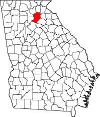 | |
| Towns | ||
| Unincorporated communities | ||
| Footnotes | ‡This populated place also has portions in an adjacent county or counties | |