Oakleigh Garden Historic District
|
Oakleigh Garden Historic District | |
  | |
| Location | Roughly bounded by Government, Marine, Texas, and Ann Sts. (original), Roughly bounded by Selma St., Broad St., Texas St. and Rapier Ave. (increase), Mobile, Alabama |
|---|---|
| Coordinates | 30°40′56.33″N 88°3′24.07″W / 30.6823139°N 88.0566861°WCoordinates: 30°40′56.33″N 88°3′24.07″W / 30.6823139°N 88.0566861°W |
| Area |
111.3 acres (45.0 ha) 34 acres (14 ha) (Increase) |
| Architectural style | Federal, Greek Revival, Classical Revival, Bungalow/Craftsman, Late Victorian |
| NRHP Reference # |
72000171[1] (original) 90002175[1] (increase) |
| Significant dates | |
| Added to NRHP | 13 April 1972[2] |
| Boundary increase | January 30, 1991 |
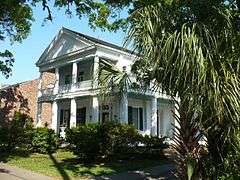
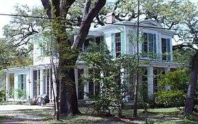
The Oakleigh Garden Historic District is a historic district in Mobile, Alabama, United States. It was placed on the National Register of Historic Places on 13 April 1972.[1] It is centered on Washington Square and was originally bounded by Government, Marine, Texas, and Ann Streets.[2] A boundary increase on 30 January 1991 increased the boundaries to Rapier Avenue, Selma, Broad, and Texas Streets. The district covers 1,453 acres (5.88 km2) and contains 288 contributing buildings. The buildings range in age from the 1820s to the 1940s with most in a variety of 19th-century architectural styles.[2]
|


References
- 1 2 3 National Park Service (2010-07-09). "National Register Information System". National Register of Historic Places. National Park Service.
- 1 2 3 "Alabama: Mobile County". "Nationalhistoricalregister.com". Retrieved 2008-01-28.

| Topics | |
|---|---|
| Lists by states |
|
| Lists by insular areas | |
| Lists by associated states | |
| Other areas | |
| |
| Wikimedia Commons has media related to Oakleigh Garden Historic District. |
This article is issued from Wikipedia - version of the 11/26/2016. The text is available under the Creative Commons Attribution/Share Alike but additional terms may apply for the media files.