ORP Kujawiak (L72)
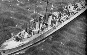 Kujawiak in 1942 | |
| History | |
|---|---|
| Name: | HMS Oakley |
| Builder: | Vickers-Armstrongs,Tyne |
| Laid down: | 22 November 1939 |
| Launched: | 30 October 1940 |
| Commissioned: | 17 June 1941 |
| Name: | ORP Kujawiak |
| Commissioned: | June 1941 |
| Fate: | sunk by mine on 16 June 1942, near Malta |
| General characteristics | |
| Class and type: | Type II Hunt-class destroyer |
| Displacement: |
|
| Length: | 85 m (279 ft) |
| Beam: | 9.5 m (31 ft) |
| Draught: | 2.4 m (7 ft 10 in) |
| Propulsion: | powered by 2 shaft steam turbines 19,000 hp (14,200 kW) |
| Speed: | 27 knots (50 km/h) |
| Range: |
|
| Complement: | 160 |
| Armament: |
|
ORP Kujawiak was a British Type II Hunt-class destroyer escort, formerly named HMS Oakley.
Kujawiak was built by Vickers-Armstrongs at the company's High Walker yard on the River Tyne. Her keel was laid down on 22 November 1939 and she was launched on 30 October 1940. Originally commissioned into the Royal Navy, she was renamed and commissioned into the Polish Navy in June 1941.
Kujawiak was sunk on 16 June 1942 after running into a mine near Malta while participating in Operation Harpoon. 13 Polish sailors died and 20 were wounded.
Details of war service
Details of war service for ORP Kujawiak:[1]
1941
On 18 June Kujawiak came under attack by German aircraft whilst on passage from Tyne to Scapa Flow to work-up for operational service with ships of Home Fleet. Fire from the aircraft hit the 4-inch ready-use ammunition which exploded causing one fatal casualty. On 25 July she joined the 15th Destroyer Flotilla based at Plymouth for local convoy escort and patrol duties.
Later that year on 23 October Kujawiak deployed with fellow Polish destroyer ORP Krakowiak for escort of inward Convoy SL89 during final stage of passage in Irish Sea from Freetown into Liverpool. On 22 December she sailed from Scapa Flow as part of Force J to carry out landings on the Lofoten Islands as part of Operation Claymore. Two days later on 27 December the destroyer sustained slight damage from a near miss during air attacks.
1942
In June 1942 Kujawiak was nominated for loan service with Home Fleet for escort of planned Malta Relief convoy (Operation Harpoon). On 6 June she joined military Convoy WS19S in the Northwest Approaches as part of Ocean Escort for passage to Gibraltar. On 12 June she joined Force X at Gibraltar for escort of convoy for passage to Malta through Sicilian Narrows. On 14 June the convoy came under heavy and sustained air attacks during which the cruiser Liverpool was damaged. The following day the air attacks continued and Kujawiak went into action with Italian warships attempting to intercept and attack the convoy.
Near midnight on 16 June, while entering Grand Harbor, Malta Kujawiak sustained major structural damage forward after detonating a mine while going to the aid of Badsworth after she had struck a mine. Kujawiak sank before a successful tow could be achieved.
Wreck of Kujawiak
Search for wreck
In December 2011, marine documentary-maker Emi Farrugia announced plans to search for the wreck of Kujawiak. An approximate position given by the British Ministry of Defence gave no proper indication of the wreck's location and Farrugia stated that the search would focus on at least 8 square kilometres (3.1 sq mi) circling the three approximate positions that are now in hand.[2]
Discovery of wreck
On 22 September 2014 a team of Polish explorers and an American from the Wreck Expeditions Association discovered the resting place of Kujawiak,[3] designated L72, off of Malta.[4]
The expedition team consisted of Team Leader Peter Wytykowski, Expedition Leader Roman Zajder, Michał Szczepaniak, Robert Głuchowski, Bartek Grynda -an underwater technology and remotely operated underwater vehicle (ROV) specialist-, Marcin Sadowski, Agata Radecka -whose grandmother's uncle was the commander of Kujawiak-, and Chris Kraska of the Ohio Maritime Archaeological Survey Team -whose father was a seaman on Kujawiak and survived her sinking. Using ROV footage and original blueprints from the Hunt Type II escort destroyer the team has ascertained that her only possible identity is Kujawiak.[5]
The discovery has been shared with Maltese and Polish officials but the coordinates of the wreck are being kept secret for the time being. The Maltese government is awaiting the team's final report and has indicated the wreck site will be designated a historic site and a war grave.[6]
The team returned to Malta in the summer of 2015 and made several dives on the wreck taking video footage. They also placed on the wreck a memorial plaque to the sailors who perished during her sinking. The team returned again in 2016, this time with a mission to map the wreck further and locate the ships bell.
After a series of dives team members Edd Stockdale, Peter Wytykowski, Mark Alexander and Steve Wilkinson located and photographed the Bell aka 'Heart of L72' and have applied for permission to recover it for the Museum.
Heart of L72 Expedition team members: Arthur Castillo, John Wood, Timmy Gambin, Daniel Barber, Mark Jones, Mark Alexander, Peter Wytykowski, Roman Zajder (Expedition Leader), Edd Stockdale, Scott DellaPeruta, Mariusz Borowiak, Robert Piasta and Steve Wilkinson (DSO).
Commanding officers
- Komandor podporucznik Ludwik Lichodziejewski
References
- ↑ "Details of War Service" naval-history.net
- ↑ Times of Malta "Search is on for Polish wartime frigate sunk near Malta" 16 Dec 2011
- ↑ "Odnaleźli wrak okrętu wojennego ORP..." (in Polish). fakt.pl. 25 September 2014. Retrieved 17 February 2015.
- ↑ "September 22nd, ORP Kujawiak found." www.orpkujawiak.com
- ↑ Weckwerth, Marek (4 October 2014). "Wrak polskiego okrętu wojennego zlokalizowano w pobliżu Malty, 72 lata po jego zatonięciu na minie. Pozostanie podwodnym grobem" (in Polish). Gazeta Pomorska. Retrieved 17 February 2015.
- ↑ "ORP Kujawiak odnaleziony. Wrak znajduje się 95 metrów pod wodą u wybrzeży Malty" (in Polish). Radio Gdansk. 25 September 2014. Retrieved 17 February 2015.
Coordinates: 35°53′N 14°35′E / 35.883°N 14.583°E
| Shipwrecks |
|
|---|---|
| Other incidents |
|
1941 May 1942 | |