Ośno Lubuskie
| Ośno Lubuskie | |||
|---|---|---|---|
|
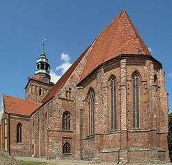
Church of St. Jacob | |||
| |||
 Ośno Lubuskie | |||
| Coordinates: 52°27′08″N 14°52′39″E / 52.45222°N 14.87750°E | |||
| Country |
| ||
| Voivodeship | Lubusz | ||
| County | Słubice | ||
| Gmina | Ośno Lubuskie | ||
| Area | |||
| • Total | 8.01 km2 (3.09 sq mi) | ||
| Population (2011) | |||
| • Total | 3,886 | ||
| • Density | 490/km2 (1,300/sq mi) | ||
| Postal code | 69-220 | ||
| Website | http://www.osno.pl | ||


Ośno Lubuskie [ˈɔɕnɔ luˈbuskʲɛ] (German: Drossen) is a town in Lubusz Voivodeship, Poland, with 3,886 inhabitants (2011).
History

In the early Piast period, a fortified settlement existed nearby the town. Ośno Lubuskie was mentioned for the first time in 1252, as " civitas forensi Osna ". The privilege of the city was received in 1282 from the bishops of Lubusz and the first mayor of the city was Dzierżko of Chyciny. At the beginning, Ośno was owned by the Bishops of Lubusz, and since 1258 by the Brandenburg margraves. Formally, the bishops gave the city to Brandenburg in 1401. Prior to 1347 Ośno Lubusz received full civic rights and in 1369 it received the right to mint its own coins. Initially it was a fortified trading settlement, but over the time it evolved into a city. During the late Middle Ages Ośno became the center of Torzymska plain, and became the capital from 1447, when the county was established.
The city was several times on fire and it did not avoid war and pestilence. Before the war Drossen was famous for its beer produced in the Drossen brewery, plantation of flowers, asparagus and currants.
In 1945 due to heavy bombing and battles nearby, the city was left 70% destroyed and finally was occupied by Red Army on 1 February 1945. After the war Drossen was incorporated into Poland and was renamed Ośno Lubuskie.
Monuments
There are several historical monuments in the town. These include:
- Parish Church of St. Jacob, Gothic, dating back to the 14th century. It is the oldest building in the city.
- Church belonging to the Nowoapostolski Municipality.
- Cemetery chapel of St. Gertrude, late Gothic from the mid-fifteenth century.
- Defensive walls, 15th century. The medieval city walls were erected in 1477, which provided 12 towers. The walls surround the city at 1,350 meters in length.
- City Hall, neo-Gothic, designed by architect Emil Flaminius.
- Synagogue
- Old synagogue
- Jewish cemetery
- Tenements in the city center dating back to the 18th century
International relations
Twin towns – Sister cities
Ośno Lubuskie is twinned with:
References
- ↑ "Eichwalde Twin Towns". Europeprize.net. Retrieved 19 August 2013.
External links
- Jewish Community in Ośno Lubuskie on Virtual Shtetl
| Wikimedia Commons has media related to Ośno Lubuskie. |
Seat: Słubice | ||
| Urban-rural gminas |  | |
| Rural gmina | ||
Coordinates: 52°27′08″N 14°52′39″E / 52.45222°N 14.87750°E