Bayi District
| Bayi 巴宜区 • བྲག་ཡིབ་ཆུས། | |
|---|---|
| District | |
|
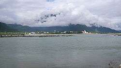
View of Bayi Town from the Nyang River | |
.png) Location of Bayi District (red) in Nyingchi (yellow) and the TAR | |
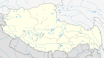 Bayi Location of the seat in the Tibet AR | |
| Coordinates: 30°17′06″N 94°40′17″E / 30.28500°N 94.67139°E | |
| Country | People's Republic of China |
| Region | Tibet |
| Prefecture-level city | Nyingchi |
| District seat | Bayi Town |
| Time zone | China Standard (UTC+8) |
| Bayi | |||||||
| Chinese name | |||||||
|---|---|---|---|---|---|---|---|
| Chinese | 巴宜 | ||||||
| |||||||
| Tibetan name | |||||||
| Tibetan | བྲག་ཡིབ། | ||||||
| |||||||
Bayi District, formerly Nyingchi County, is a District of Nyingchi in the Tibet Autonomous Region. Bayi Town, the administrative capital of Nyingchi, is located within the district.
Geography
Bayi is located in the middle reaches of the Yarlung Tsangpo River. Both steep cliffs and flat valleys exist in the area. The average altitude is 3000 metres above sea level. "The lowest places are just around 1,000 metres above sea level."[1]
There are many scenic places in or near Bayi.
"The Seche La Mountain Scenic Spot, in the east of Nyingchi County, is a part of the Nyainqentanglha Mountain Range, the watershed of the Nyang River and the Polung Zangbo River. The Sichuan-Tibetan Highway passes by. Standing at the mountain pass at 4,728 meters above sea level, one can admire the sunrise, sea of clouds, endless forest and the grand Namjagbarwa Peak."[2]
Güncang village (Chinese: 更章门巴族乡; pinyin: Gēngzhāng Ménbā zú Xiāng) and Pelung Township by the Sichuan-Tibet Highway are home to the Moinba ethnic group.[3]
Administrative divisions
| Name | Hanzi | Hanyu Pinyin | Tibetan | Wylie | Population (2010)[4] | Area (km²) |
|---|---|---|---|---|---|---|
| Bayi Subdistrict | 八一街道 | Bāyī Jiēdào | བྲག་ཡིབ་གྲོང། | brgyad gcig | 3,9110 | |
| Shuangyong Road Subdistrict | 双拥路街道 | Shuāngyōnglù Jiēdào | ||||
| Nyingchi | 林芝镇 | Línzhī Zhèn | ཉིང་ཁྲི་གྲོང་་རྡལ། | nying khri grong | 3,267 | |
| Bêba Town | 百巴镇 | Bǎibā Zhèn | 3,748 | |||
| Lunang Town | 鲁朗镇 | Lǔlǎng Zhèn | 1,588 | |||
| Puqu Township | 布久乡 | Bùjiǔ Xiāng | 3,128 | |||
| Mainri Township | 米瑞乡 | Mǐruì Xiāng | 2,247 | |||
| Güncang Monba Ethnic Township | 更章门巴族乡 | Gèngzhāng Ménbāzú Xiāng | 1,614 |
Culture
Buchu Monastery is located about 28 km (17 mi) south of Bayi Town. Lamaling Monastery is located in Puqu Township.[5]
"The Benri La Mountain near the Dagzê Village on the western slope of the mountain is a sacred site of the Tibetan Bön Sect and one of the four great holy mountains in Tibet."[2] It is located in the southeast of Pulha, north of the Yarlung Tsangpo River. Pilgrimages attract devotees throughout the year. "Every tenth day of the eighth month of the Tibetan calendar, a grand mountain worshiping activity is held, which is called "Nangbolhasoi," meaning "seeking for treasures from immortals."[2] "Each year during the Sagadawa Festival the pilgrims will come to worship and circle around the holy mountain." Seven Bon temples were built around the mountain.[6]
Climate
"Under the influence of the monsoon from the Indian Ocean, the area has neither scorching summer nor freezing winter. With ample rainfall, the air is quite humid. The sunshine is long and the frost is short."[1]
| Climate data for Nyingchi County (1971−2000) | |||||||||||||
|---|---|---|---|---|---|---|---|---|---|---|---|---|---|
| Month | Jan | Feb | Mar | Apr | May | Jun | Jul | Aug | Sep | Oct | Nov | Dec | Year |
| Average high °C (°F) | 8.3 (46.9) |
9.5 (49.1) |
13.0 (55.4) |
16.4 (61.5) |
19.2 (66.6) |
21.4 (70.5) |
22.1 (71.8) |
22.0 (71.6) |
20.3 (68.5) |
17.3 (63.1) |
13.4 (56.1) |
9.8 (49.6) |
16.1 (60.9) |
| Average low °C (°F) | −5 (23) |
−2.7 (27.1) |
0.6 (33.1) |
3.4 (38.1) |
6.7 (44.1) |
10.3 (50.5) |
11.5 (52.7) |
11.0 (51.8) |
9.5 (49.1) |
5.3 (41.5) |
−0.6 (30.9) |
−4.4 (24.1) |
3.8 (38.8) |
| Average precipitation mm (inches) | 1.6 (0.063) |
4.4 (0.173) |
17.0 (0.669) |
47.1 (1.854) |
74.3 (2.925) |
125.2 (4.929) |
133.9 (5.272) |
123.3 (4.854) |
114.6 (4.512) |
39.9 (1.571) |
5.3 (0.209) |
1.4 (0.055) |
688.0 (27.087) |
| Average precipitation days (≥ 0.1 mm) | 2.8 | 6.0 | 11.5 | 17.3 | 19.6 | 23.0 | 22.8 | 21.5 | 22.2 | 14.0 | 4.0 | 1.7 | 166.4 |
| Source: Weather China | |||||||||||||
Transport
Plans exist for the construction of a railway from Lhasa to Nyingchi. Construction work is expected to start in September 2014, and to take 6 years.[7]
References
- 1 2 "Tibet travel guide of Nyingchi Region, Bayi Town". Retrieved 2013-10-20.
- 1 2 3 "The Seche La Mountain Scenic Spot". Tibet Travel Service, Tibet Tour. Archived from the original on 2013-10-23. Retrieved 2013-10-20.
- ↑ "Moinba Ethnic Group and its customs". Tibet Travel Guide-Let's Travel Tibet. Retrieved 2013-10-20.
- ↑ shi, Guo wu yuan ren kou pu cha ban gong; council, Guo jia tong ji ju ren kou he jiu ye tong ji si bian = Tabulation on the 2010 population census of the people's republic of China by township / compiled by Population census office under the state; population, Department of; statistics, employment statistics national bureau of (2012). Zhongguo 2010 nian ren kou pu cha fen xiang, zhen, jie dao zi liao (Di 1 ban. ed.). Beijing Shi: Zhongguo tong ji chu ban she. ISBN 978-7-5037-6660-2.
- ↑ "Puqu Lama Ling Monastery". Tibet Travel Guide-Let's Travel Tibet. Retrieved 2013-10-20.
- ↑ "Benri Mountain". At0086.com. Retrieved 2013-10-20.
- ↑ 拉萨至林芝铁路预计今年九月开建 Archived February 1, 2014, at the Wayback Machine. (Construction of the Lhasa-Nyingchi railway is planned to start in September of this year), 2014-1-15

Coordinates: 30°17′06″N 94°40′17″E / 30.28500°N 94.67139°E