Nuri
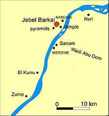
Nuri is a place in modern Sudan on the south (east) side of the Nile. Close to it, there are pyramids belonging to Nubian kings. Nuri is situated about 15 km north of Sanam, and 10 km from Jebel Barkal. All these remains belonged to the ancient city Napata, the first capital of the Nubian kingdom of Kush.
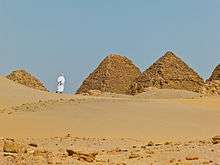
The earliest pyramid (Nu. 1) at Nuri belongs to king Taharqa which measures 51.75 metres square by 40 or by 50 metres high. His successor Tantamani was buried in el-Kurru, but all following Nubian kings and many of their wives till Nastasen (Nu. 15) (about 330 BC) were buried here.[1] The pyramids at Nuri are in general smaller than the Egyptian ones and are today often heavily destroyed, but they often still contained substantial parts of the funerary equipment of the Kushite rulers who were buried here. During the Christian era, a church was erected here.[2] The church was built of many old stones, including several stelae originally coming from the pyramids.
The pyramids were systematically excavated by George Reisner.
The pyramids of Nuri together with other buildings in the region around Gebel Barkal have been placed on the UNESCO list of world cultural heritage sites since 2003.[3]
Tombs at Nuri
- See List of monarchs of Kush for more information.


The royal family of Kush was buried in the cemeteries of Nuri and el-Kurru.[4]
The pyramids of Nuri are built on two separate plateaus. The highest point in the cemetery is taken up by Taharqa's pyramid on the western plateau. The pyramids of the other kings are located on the eastern plateau. The pyramids of the royal women are placed closer to Taharqa's pyramid on the western plateau. These pyramids fall into three groups: (1) A group of pyramids is located to the south and west of Taharqa's pyramid; (2) Two parallel rows are located to the north of Taharqa's pyramid; (3) A group of very small tombs is located to the far north.
The King's Mothers were buried in the southern group, but this is not an area exclusively used for the burial of King's Mothers. Most of the King's Wives were buried in the parallel rows just north of Taharqa's tomb. The tombs to the far north were much smaller and may have been built for wives of lesser rank.[5]
- Nuri 1 - King Taharqa
- Nuri 2 - King Amaniastabarqa
- Nuri 3 - King Senkamanisken
- Nuri 4 - King Siaspiqa
- Nuri 5 - King Malonaqen
- Nuri 6 - King Anlamani, son of King Senkamanisken
- Nuri 7 - King Karkamani
- Nuri 8 - King Aspelta, son of King Senkamanisken and Queen Naparaye
- Nuri 9 - King Aramatle-qo, son of Aspelta
- Nuri 10 - King Amaninatakilebte
- Nuri 11 - King Malewiebamani
- Nuri 12 - King Amanineteyerike, son of King Malewiebamani
- Nuri 13 - King Harsiotef
- Nuri 14 - King Akhraten
- Nuri 15 - King Nastasen
- Nuri 16 - King Talakhamani
- Nuri 17 - King Baskakeren, son of King Malewiebamani
- Nuri 18 - King Analmaye
- Nuri 19 - King Nasakhma
- Nuri 20 - King Atlanersa Son of Taharqa
- Nuri 21 - Possibly Takahatenamun, Queen. Wife of Taharqa
- Nuri 22 - Possibly Amanimalel, Queen. Wife of King Senkamanisken
- Nuri 23 - Masalaye, Queen? Probably wife of King Senkamanisken
- Nuri 24 - Nasalsa Queen. Daughter of Atlanersa, wife of King Senkamanisken
- Nuri 25 - Maletaral II, Queen?. Time of King Amaninatakilebte
- Nuri 26 - Amanitakaye, Queen. Daughter of Aspelta, sister-wife of Aramatle-qo, mother of Malonaqen
- Nuri 27 - Madiqen, Queen. Wife of Anlamani
- Nuri 28 - Henuttakhebi[t], Queen. Wife of Aspelta
- Nuri 29 - Pi'ankhqew-qa Queen? Possibly wife of King Siaspiqa
- Nuri 31 - Saka'aye, Queen. Probably mother of King Malewiebamani
- Nuri 32 - Akhrasan, Queen. Temp. King Malewiebamani
- Nuri 34 - Henutirdis, Queen. From the time of King Harsiotef
- Nuri 35 - Possibly Queen Abar, wife of Piye, Mother of Taharqa
- Nuri 36 - Atakhebasken Queen. Wife of Taharqa
- Nuri 38 - Akhe(qa?), Queen. Daughter of Aspelta and wife of Aramatle-qo
- Nuri 39 - Maletasen, Queen. Wife of Aramatle-qo
- Nuri 40 - Meqemale, Queen. Possibly wife of Aspelta
- Nuri 41 - Maletaral(?) I, Queen. Wife of Atlanersa
- Nuri 42 - Asata, Queen. Wife of Aspelta
- Nuri 44 - Batahaliye, Queen. Wife of Harsiotef
- Nuri 45 - Tagtal (?), Queen. Wife of King Malonaqen
- Nuri 43 - Yeturow, Queen. Sister-Wife of Atlanersa
- Nuri 55 - Atmataka, Queen. Wife of Aramatle-qo
- Nuri 56 - Possibly Sekhmakh, Queen. Wife of Nastasen
- Nuri 57 - Pi'ankh-her( ?), Queen. Wife of Aramatle-qo
- Nuri 58 - Artaha, Queen. Wife of Aspelta
- Nuri 59 - Malaqaye, Queen. Possibly a wife of King Tantamani
- Nuri 61 - Atasamale, Queen. Possibly a wife of Amanineteyerike
References
- ↑ Compare the list in Derek A. Welsby: The Kingdom of Kush. British Museum Press, London 1996, pp. 207-208 ISBN 0-7141-0986-X
- ↑ Dunham, The Royal Cemeteries of Kush II, Nuri, fig. 216
- ↑ Gebel Barkal and the Sites of the Napatan Region at UNESCO.org
- ↑ Dows Dunham and M. F. Laming Macadam, "Names and Relationships of the Royal Family of Napata", The Journal of Egyptian Archaeology, Vol. 35 (December 1949), pp. 139-149
- ↑ Angelika Lohwasser, "Queenship in Kush: Status, Role and Ideology of Royal Women", Journal of the American Research Center in Egypt, Vol. 38 (2001), pp. 61-76
Literature
- Dows Dunham. The Royal Cemeteries of Kush II, Nuri, Boston (Mass.): Museum of Fine Arts, 1955.
External links
Coordinates: 18°33′51.74″N 31°54′58.99″E / 18.5643722°N 31.9163861°E