Numinbah Valley
| Numinbah Valley Gold Coast, Queensland | |||||||||||||
|---|---|---|---|---|---|---|---|---|---|---|---|---|---|
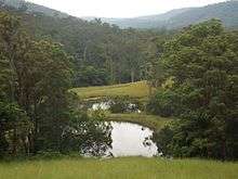
 Numinbah Valley from Rosin's Lookout | |||||||||||||
| Population | 294 | ||||||||||||
| Established | 1880 | ||||||||||||
| Postcode(s) | 4211 | ||||||||||||
| Location | 35 km (22 mi) from Southport | ||||||||||||
| LGA(s) | City of Gold Coast | ||||||||||||
| State electorate(s) | Mudgeeraba | ||||||||||||
| Federal Division(s) | McPherson | ||||||||||||
| |||||||||||||
The Numinbah Valley is a valley and suburb in the Gold Coast hinterland in South East Queensland, Australia. This Scenic Rim valley covers 116 km²[1] and contains cleared grazing land, rocky outcrops, waterfalls, rainforest walks and good hinterland scenery. Lonely Planet has described the valley as the most beautiful in South East Queensland.[2]
Compared to other areas of the Gold Coast the Numinbah Valley has remained largely undeveloped in recent decades. To the east is the Springbrook plateau. On the eastern side of the valley is the Natural Bridge in Springbrook National Park and to the west lies the Lamington Plateau and the Lamington National Park. To the south is the Tweed Valley in northern New South Wales.
Vegetation in the valley includes dry and wet sclerophyll forest. The valley is part of the upper catchment area for the Nerang River which flows into the Hinze Dam in the lowest elevated and most northern part of the valley. The communities of Advancetown and the small township of Numinbah are located in Numinbah Valley.
History

The valley was first explored by timber cutters seeking cedar in 1845.[3] Bullocks hauled the felled timer to Nerang. Later in the 1860s, when a route to the Tweed Valley was discovered as surveyors mapped the Queensland/New South Wales border, settlers moved into the area.[3] A township developed in the 1880s. A sawmill operated from 1909 until 1944 when agriculture and dairying became the primary industries.[3]
Facilities

Institutions built in Numinbah Valley include the Numinbah Correctional Centre and Numinbah Valley State Primary School which was established in 1927.[4] A Numinbah Valley Landcare group operates in the valley.
Bornhoffen PCYC or the Numinbah Valley Environmental Education Centre caters for large groups of students. These large recreational facilities are situated in the southern and highest part where the headwaters of the Nerang River coalesce.
The Gold Coast Hinterland Great Walk traverses the valley from O'Reilly's Guesthouse in the west to Springbrook National Park to the east.
Industry
At one of three places in Queensland perlite is extracted from a deposit in the valley and trucked to Sydney.[5]
Heritage listings
Numinbah Valley has a number of heritage-listed sites, including the Numinbah Valley School of Arts along Nerang-Murwillumbah Road.[6]
See also
References
- ↑ "Numinbah History". Gold Coast City Council. Retrieved 27 June 2013.
- ↑ Bain, Andrew; Ethan Gelber (2009). Cycling Australia. Lonely Planet. p. 291. ISBN 174104040X. Retrieved 27 June 2013.
- 1 2 3 Environmental Protection Agency (Queensland) (2000). Heritage Trails of the Great South East. State of Queensland. p. 20. ISBN 0-7345-1008-X.
- ↑ "Numinbah Valley State School". Department of Education, Training and Employment. Retrieved 27 June 2013.
- ↑ Kogel, Jessica Elzea; Nikhil C. Trivedi; James M. Barker (2006). Industrial Minerals and Rocks: Commodities, Markets, and Users. SME. p. 687. ISBN 0873352335. Retrieved 27 June 2013.
- ↑ "Numinbah Valley School of Arts (entry 602419)". Queensland Heritage Register. Queensland Heritage Council. Retrieved 19 June 2013.
External links
| Wikimedia Commons has media related to Numinbah Valley. |
- "Gold Coast Inner Hinterland". Queensland Places. Centre for the Government of Queensland, University of Queensland. — includes Numinbah Valley
Coordinates: 28°08′28.06″S 153°13′26.51″E / 28.1411278°S 153.2240306°E