North Shore, Northern & Western Line

The North Shore, Northern & Western Line (numbered T1, coloured yellow) is a commuter rail line operated by Sydney Trains in Sydney, New South Wales, Australia. It serves the North Shore, Northern Suburbs and parts of the Inner West and Western Suburbs.
History
Following victory in the 2011 New South Wales election, the O'Farrell Government embarked on reform of transport in New South Wales. In November 2011, a new organisation, Transport for NSW, was created to improve planning and coordination of transport projects and services. The organisation developed a new rail timetable and branding, which was put into effect on 20 October 2013. This saw the merger of the North Shore Line and Western Line (Berowra - City via Gordon then to Emu Plains or Richmond via Strathfield) with the Northern Line (Hornsby - City via Macquarie Park then to Epping via Strathfield). A new numbering system was also introduced and the line was given the number T1.
Railway line history
The North Shore, Northern & Western Line utilises a number of different railway lines and is the result of various schemes to link the lines together. The line is centred around the Main Suburban railway line which runs from Central to Granville. The Main Northern and Main Western lines branch from the Main Suburban Line. The North Shore Line branches from the Main Northern Line and was later extended through the city and connected to the Main Suburban Line as well. The Epping to Chatswood line provides a second connection between the Main Northern and North Shore lines, enabling the creation of the North Shore, Northern & Western Line's current layout.
Main Western and Richmond lines
The Main Western Line opened to Penrith in 1863 as a branch from the junction with the Main South line at Granville.[4] Electrification reached Parramatta in 1928 and Penrith in 1955.[5]
A branch line was opened to Richmond in 1864 under the stewardship of engineer James Moore. Electrification from Riverstone to Richmond opened in August 1991.[6] Through running to and from Sydney commenced in 1992.
Trains from the Main Western and Richmond lines run as the Western Line.
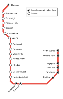
North Shore Line
The North Shore Line was opened on 1 January 1890 between Hornsby and St Leonards. The line was extended to the Sydney Harbour foreshore at Milsons Point in 1893. Transport between this original Milsons Point station and central Sydney was by ferry boat. The line was electrified in 1927.
When the Sydney Harbour Bridge was opened in 1932 a new Milsons Point station (on the bridge approach) came into operation and the North Shore Line was extended through it and over the Sydney Harbour Bridge to link with the underground lines of central Sydney. The result is that the two ends of the North Shore Line link to the Sydney railway system at Central and Hornsby.
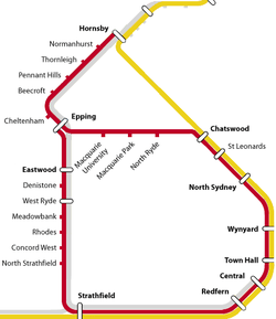
Main Northern and Epping to Chatswood lines
The traditional Northern Line was the suburban portion of the Main Northern Line which opened in 1886 and was electrified in 1926. When the Sydney Harbour Bridge was opened, the Northern Line was connected to the City underground and the North Shore line.
In 2009 the Epping to Chatwood Line was opened. The traditional Northern line route ran from Hornsby to North Sydney via Strathfield and the City. When the Epping to Chatswood Line opened, the Northern Line was split in two, with trains from north of Epping operating via the new link, approaching the city via the North Shore Line and rejoining the traditional route before terminating at Epping. The Northern Line was colour coded red prior to being merged with the North Shore and Western lines. After merging, the Northern Line loop was split on weekdays, with trains from the upper Northern Line continuing to Richmond or Emu Plains.
In 2018 the Epping to Chatwood Line will be closed and be converted to a metro. As a result, the traditional Northern line route from Hornsby to Central via Strathfield will be reinstated with expanded train services on the North Shore line. This will coincide the proposed new timetable that year.
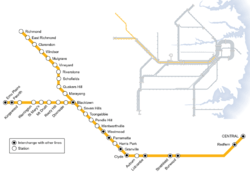
Route
The route is complex and features many branches. It passes through a number of business districts and major centres, namely Hornsby, Macquarie Park, Chatswood, North Sydney, the Central Business District, Parramatta, Blacktown and Penrith.
The line heads south from Berowra to Hornsby to using the Main Northern Line. Trains from this branch then divert on to the North Shore Line. A second branch starts at Hornsby and continues down the Main Northern Line to Epping. At Epping the line heads underground to the Macquarie employment centre and Chatswood via the Epping to Chatswood Line. The line surfaces at Chatswood and joins the Berowra branch on the North Shore Line for the run south towards the City. Trains pass through North Sydney station before heading across the Sydney Harbour Bridge, through the western limb of the City Circle and the stations of Central and Redfern.
Services then run along the Main Suburban Railway, usually using the middle 'Suburban' pair of the six tracks between Redfern and Strathfield. Services do not stop at intermediate stations between Redfern and Burwood. At Strathfield, trains to Epping via Rhodes usually head onto a flyover over the 'Main lines', before heading north back on the Main Northern Line, crossing the Parramatta River between Rhodes and Meadowbank, and terminating at Epping's surface platforms. Other services continue west from Strathfield to Granville where trains join the Main Western Line. After passing through Parramatta, trains reach Blacktown, where the line divides in two. A western branch continues along the Main Western Line as far as Emu Plains and a north-western branch heads to Richmond using the Richmond Line.
Services
There are no general stopping patterns for services during weekdays peak hours. However, there are general stopping patterns for other times. Services stated here do not include express trains between City and Blue Mountains or Newcastle.
Stopping Patterns (Weekdays outside peak hours)
- Hornsby to and from Epping (surface) all stations to Chatswood via Gordon, all stations to North Sydney, all stations to Central, Redfern, Burwood and Strathfield, then all stations to Epping. (2 trains per hour)
- Berowra to and from Epping (surface) via all stations to Chatswood via Gordon, all stations to North Sydney, all stations to Central, Redfern, Burwood and Strathfield, then all stations to Epping. (2 trains per hour)
- Hornsby to and from Richmond via all stations to Epping (underground), Macquarie University, Macquarie Park, North Ryde, Chatswood, all stations to North Sydney, all stations to Central, Redfern, Strathfield, (Lidcombe / Granville), Parramatta, (Westmead, Seven Hills) and Blacktown then all stations to Richmond. (2 trains per hour)
- Hornsby to and from Penrith via all stations to Epping (underground), Macquarie University, Macquarie Park, North Ryde, Chatswood, all stations to North Sydney, all stations to Central, Redfern, Strathfield, (Lidcombe / Granville), Parramatta, (Westmead, Seven Hills) and Blacktown then all stations to Penrith (2 trains per hour)
- North Sydney to and from Emu Plains via all stations to Central, Redfern, Burwood, Strathfield, Lidcombe, all stations to Penrith and Emu Plains. (2 trains per hour)
Stopping Patterns (Weekends)
- Berowra to and from Penrith, via all stations to Chatswood via Gordon, all stations to North Sydney, all stations to Central, Redfern, Strathfield, Lidcombe, all stations to Granville, Parramatta, Westmead, Seven Hills, Blacktown and all stations to Penrith. (2 trains per hour)
- Hornsby to and from Richmond via all stations to Chatswood via Gordon, all stations to North Sydney, all stations to Central, Redfern, Burwood, Strathfield, Lidcombe, Granville, Harris Park, Parramatta, all stations to Blacktown and all stations to Richmond. (2 trains per hour)
- Hornsby to and from Epping (surface) via all stations to Epping (underground), Macquarie University, Macquarie Park, North Ryde, Chatswood, Artarmon, St Leonards, North Sydney all stations to Central, Redfern, Burwood, Strathfield and all stations to Epping. (2 trains per hour)
- Hornsby to and from Chatswood via all stations to Epping (underground), Macquarie University, Macquarie Park and North Ryde. (2 trains per hour)
Emu Plains is served by the Blue Mountains Line on weekends.
Stations
| Name | Code | Distance from Central [7][8][9][10] |
Opened [7][8][9][10] |
Railway Line | Serving Suburbs | Connection with other Lines |
|---|---|---|---|---|---|---|
| Berowra - Chatswood via Gordon | ||||||
| Berowra | BER | 44.7 km | 1887 | Main Northern | Berowra | NSW TrainLink |
| Mount Kuring-gai | MKI | 40.7 km | 1901 | Main Northern | Mount Kuring-gai | NSW TrainLink* *limited services only |
| Mount Colah | MCL | 37.7 km | 1887 | Main Northern | Mount Colah | NSW TrainLink* *limited services only |
| Asquith | ASQ | 35.7 km | 1915 | Main Northern | Asquith, Hornsby Heights | NSW TrainLink* *limited services only |
| Hornsby | HBY | 33.9 km | 1886 | North Shore | Hornsby, Waitara, Hornsby Heights. | NSW TrainLink |
| Waitara | WAI | 24.2 km | 1895 | North Shore | Waitara | |
| Wahroonga | WRO | 22.6 km | 1890 | North Shore | Wahroonga | |
| Warrawee | WAE | 21.9 km | 1900 | North Shore | Warrawee, Wahroonga | |
| Turramurra | TRM | 20.8 km | 1890 | North Shore | Turramurra, North Turrmarra, South Turramurra, St Ives | |
| Pymble | PYM | 18.9 km | 1890 | North Shore | Pymble, West Pymble, St Ives | |
| Gordon | GDN | 17.1 km | 1890 | North Shore | Gordon, West Pymble | |
| Killara | KIL | 15.9 km | 1899 | North Shore | Killara, East Lindfield | |
| Lindfield | LFD | 14.6 km | 1890 | North Shore | Lindfield, West Lindfield, East Lindfield | |
| Roseville | RSV | 13.3 km | 1890 | North Shore | Roseville | |
| Hornsby - Chatswood via Macquarie University | ||||||
| Hornsby | HBY | 35.3 km | 1886 | Main Northern | Hornsby, Waitara, Hornsby Heights. | NSW TrainLink |
| Normanhurst | NMH | 33.1 km | 1895 | Main Northern | Normanhurst | |
| Thornleigh | THL | 30.8 km | 1886 | Main Northern | Thornleigh, Westleigh | |
| Pennant Hills | PLL | 30 km | 1886 | Main Northern | Pennant Hills, Cherrybrook | |
| Beecroft | BCF | 28.3 km | 1886 | Main Northern | Beecroft, West Pennant Hills | |
| Cheltenham | CHT | 26.8 km | 1898 | Main Northern | Cheltenham | |
| Epping (underground) | EPG | 24.8 km | 2009 | Epping to Chatswood | Epping, North Epping, Marsfield, Carlingford. | NSW TrainLink |
| Macquarie University | MCU | 20.9 km | 2009 | Epping to Chatswood | Macquarie University, Marsfield | |
| Macquarie Park | MQP | 19.6 km | 2009 | Epping to Chatswood | Macquarie Park | |
| North Ryde | NRQ | 18.2 km | 2009 | Epping to Chatswood | North Ryde | |
| Chatswood - Strathfield | ||||||
| Chatswood | CWD | 11.7 km | 1890 | North Shore | Chatswood | |
| Artarmon | ATO | 10.3 km | 1898 | North Shore | Artarmon, Willoughby, Narenburn, Crows Nest. | |
| St Leonards | STL | 8.4 km | 1890 | North Shore | St Leonards, Gore Hill, Osbourne Park, Greenwich, Crows Nest. |
|
| Wollstonecraft | WSC | 7.2 km | 1893 | North Shore | Wollstonecraft, Greenwich, Crows Nest. | |
| Waverton | WVT | 6.1 km | 1893 | North Shore | Waverton, Lavender Bay, North Sydney | |
| North Sydney | NSY | 5.1 km | 1932 | North Shore | North Sydney, Crows Nest | |
| Milsons Point | MPT | 4.4 km | 1932 | North Shore | Milsons Point, Kirribilli | |
| Wynyard | WYN | 2.1 km | 1932 | North Shore | Sydney CBD, The Rocks, Millers Point | ■ Airport, Inner West & South Line ■ Bankstown Line |
| Town Hall | TWH | 1.2 km | 1932 | North Shore | Sydney CBD, Darling Harbour |
■ Airport, Inner West & South Line ■ Eastern Suburbs & Illawarra Line ■ Bankstown Line NSW TrainLink* *limited services only |
| Central | CEN | 0 km | 1855 | North Shore | Sydney CBD, Chippendale, Strawberry Hills, Ultimo, Surrey Hills |
■ Airport, Inner West & South Line ■ Eastern Suburbs & Illawarra Line ■ Bankstown Line NSW TrainLink |
| Redfern | RDF | 1.3 km | 1878 | Main Suburban | Redfern, Waterloo, Darlington, | ■ Airport, Inner West & South Line ■ Eastern Suburbs & Illawarra Line ■ Bankstown Line NSW TrainLink* *peak hours only |
| Burwood | BUW | 10.6 km | 1855 | Main Suburban | Burwood | ■ Airport, Inner West & South Line |
| Strathfield | SFD | 11.8 km | 1876 | Main Suburban | Strathfield, South Strathfield | ■ Airport, Inner West & South Line NSW TrainLink |
| Strathfield - Epping | ||||||
| North Strathfield | NST | 13.4 km | 1918 | Main Northern | North Strathfield, Concord West, Concord | |
| Concord West | CCW | 14.5 km | 1887 | Main Northern | Concord West, Liberty Grove, Concord | |
| Rhodes | RHS | 16.6 km | 1886 | Main Northern | Rhodes, Liberty Grove | |
| Meadowbank | MEB | 18.2 km | 1887 | Main Northern | Meadowbank, Shepherd's Bay, Putney, Melrose Park |
|
| West Ryde | WSR | 19.2 km | 1886 | Main Northern | West Ryde, Ryde | |
| Denistone | DST | 20.2 km | 1937 | Main Northern | Denistone | |
| Eastwood | EAW | 21.4 km | 1886 | Main Northern | Eastwood, Marsfield | NSW TrainLink |
| Epping (aboveground) | EPG | 23.4 km | 1886 | Main Northern | Epping, North Epping, Marsfield, Carlingford. | NSW TrainLink |
| Strathfield - Blacktown | ||||||
| Lidcombe | LDC | 16.6 km | 1858 | Main Suburban | Lidcombe | ■ Airport, Inner West & South Line ■ Bankstown Line ■ Olympic Park Line NSW TrainLink* *limited services only |
| Auburn | AUB | 18.7 km | 1877 | Main Suburban | Auburn | ■ Airport, Inner West & South Line |
| Clyde | CLJ | 20.6 km | 1882 | Main Suburban | Clyde, Granville | |
| Granville | GRN | 21.4 km | 1860 | Main Suburban | Granville | ■ Airport, Inner West & South Line NSW TrainLink* *limited services only |
| Harris Park | HPK | 22.6 km | After 1883 | Main Western | Harris Park | ■ Cumberland Line |
| Parramatta | PTA | 23.2 km | 1860 | Main Western | Parramatta, North Paramatta, | ■ Cumberland Line NSW TrainLink |
| Westmead | WMD | 25.1 km | 1883 | Main Western | Westmead | ■ Cumberland Line NSW TrainLink* *limited services only |
| Wentworthville | WWV | 26.7 km | 1883 | Main Western | Wentworthville | ■ Cumberland Line |
| Pendle Hill | PDH | 28.3 km | 1924 | Main Western | Pendle Hill | ■ Cumberland Line |
| Toongabbie | TBB | 29.9 km | 1880 | Main Western | Toongabbie | ■ Cumberland Line |
| Seven Hills | SEV | 32.1 km | 1863 | Main Western | Seven Hills | ■ Cumberland Line |
| Blacktown | BAK | 34.8 km | 1860 | Main Western Richmond |
Blacktown | ■ Cumberland Line NSW TrainLink |
| Blacktown - Emu Plains | ||||||
| Doonside | DOD | 38.6 km | 1880 | Main Western | Doonside | |
| Rooty Hill | RYH | 40.9 km | 1861 | Main Western | Rooty Hill | |
| Mount Druitt | MTT | 43.3 km | 1881 | Main Western | Mount Druitt | |
| St Marys | STM | 47.4 km | 1862 | Main Western | St Marys, Dunheved | |
| Werrington | WRT | 49.1 km | 1868 | Main Western | Werrington | |
| Kingswood | KWD | 52.7 km | 1887 | Main Western | Kingswood | |
| Penrith | PEN | 55.1 km | 1863 | Main Western | Penrith | NSW TrainLink |
| Emu Plains | EPS | 57.4 km | 1868 | Main Western | Emu Plains, Emu Heights | NSW TrainLink |
| Blacktown - Richmond | ||||||
| Marayong | MYG | 37.4 km | 1922 | Richmond | Marayong | ■ Cumberland Line |
| Quakers Hill | QKH | 40.1 km | 1872 | Richmond | Quakers Hill | ■ Cumberland Line |
| Schofields | SFS | 43.8 km | 1870 | Richmond | Schofields | ■ Cumberland Line |
| Riverstone | RVS | 46.0 km | 1864 | Richmond | Riverstone | |
| Vineyard | VYR | 49.2 km | 1935 | Richmond | Vineyard | |
| Mulgrave | MUV | 52.6 km | 1864 | Richmond | Mulgrave | |
| Windsor | WSR | 55.0 km | 1864 | Richmond | Windsor | |
| Clarendon | CRD | 57.2 km | 1870 | Richmond | Clarendon | |
| East Richmond | ERD | 60.0 km | 1939 | Richmond | East Richmond, Richmond | |
| Richmond | RCD | 60.7 km | 1864 | Richmond | Richmond, North Richmond | |
References
- ↑ Asset Standards Authority (19 March 2014). RailCorp electrical system general description, version 1.0 (PDF).
- ↑ Asset Standards Authority (30 April 2015). Train operating conditions manual – general instructions, version 3.0 (PDF).
- ↑ Saulwick, Jacob (24 July 2013). "Smallest stations are biggest losers in new rail timetable". Sydney Morning Herald.
- ↑ "Main West Line". Nswrail.net. Retrieved 3 January 2007.
- ↑ "Cheers for rail plan, now let's get it moving". Sydney Morning Herald, 9/6/2005. 10 June 2005. Retrieved 3 January 2007.
- ↑ "The Times Oct 1998". AATC. Retrieved 3 January 2007.
- 1 2 "NSW Rail.net Main North line". Retrieved 3 July 2007.
- 1 2 "NSW Rail.net North Shore line". Retrieved 3 July 2007.
- 1 2 "NSW Rail.net City Circle". Retrieved 3 July 2007.
- 1 2 "NSW Rail.net Main South line". Retrieved 3 July 2007.
External links
- Sydney Trains timetable - Berowra to Parramatta via City
- Sydney Trains timetable - Parramatta to Berowra via City
- Sydney Trains timetable - Hornsby or Epping to the City via Strathfield
- Sydney Trains timetable - City to Hornsby or Epping via Strathfield
- Sydney Trains timetable - Emu Plains or Richmond to Chatswood
- Sydney Trains timetable - Chatswood to Emu Plains or Richmond
- Western Fastrail
- Neety's Train Page - information on suburban stations.
- New South Wales Railways - historical information on suburban stations.
- Sydney Trains
- Australian Railmaps - information & maps of train services & stopping patterns.
- Transport Infrastructure Development Corporation project website