Northeast Siberian taiga
| Ecoregion: Northeast Siberian taiga | |
|---|---|
|
Dahurian larch trees, Kolyma region, arctic northeast Siberia | |
|
Ecoregion territory (in purple) | |
| Ecology | |
| Realm | Palearctic |
| Biome | Boreal forests/taiga |
| Geography | |
| Area | 15,293.7327 km2 (5,904.9432 sq mi) |
| Country | Russia |
| Rivers | Lena River, Kolyma River |
| Climate type | ET |

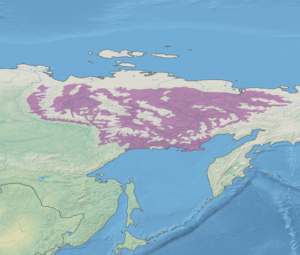
The Northeast Siberian taiga ecoregion (WWF ID:PA0605) is an area of "sparse taiga forest" between the Lena River and the Kolyma River in northeastern Siberia, Russia. The ecoregion's internal borders form a patchwork of territory constituting the lowlands around the ridges and peaks of the Verkhoyansk Range and the Chersky Range of mountains. On the southern border of the ecoregion is the north coast of the Sea of Okhotsk, giving the region maritime boreal forests as well as the continental forests situated inland. The ecoregion is one of the largest tracts of virgin boreal forest in the world, due the very sparse population and difficult access. It is mostly in the Sakha Republic (Yakutsk region).
Location and description
The ecoregion covers an area about 1,800 km west-east by 1,000 km north-south. The western border is the Lena River; beyond that is the East Siberian taiga ecoregion. The eastern edge is the Kolyma River, beyond which farther east is the Bering tundra ecoregion. To the north is a strip Arctic coastal tundra about 100 km wide, the Northeast Siberian coastal tundra ecoregion. The Okhotsk Sea to the south completes the outline of the ecoregion, but internally the Verhkoyansk and Chersky mountains (which are in the "Cherskii-Kolyma mountain tundra" ecoregion) confines the ecoregion into valleys and lowlands.[1]
The Verkhovyansk Range is an "L-shaped" range that runs down the east side of the Lena before turning west-east across the south of the ecoregion. They Chersky Range runs northwest-to-southeast through the middles of the region. Their upper slopes and peaks are too cold and dry to support the forests and flora of the lowlands in the Northeast Siberian taiga ecoregion. To the east and north of the mountains is the Kolyma River basin. In addition to the Kolyma River, the ecoregion contains the Indigirka River and the Yana River.[2]
Climate
The region has a (ET), with long, very cold winters and a brief warm summer.[3] Regions with ET climate have at least one month with temperatures averaging above 0 °C (32 °F), and hence have a period of melted snow; but ET regions also have no month averaging above 10 °C (50 °F) and hence are at the northern limit of ability to support forests.
| Center of Northeast Siberian ecoregion (65.25 N, 147.25 E) | ||||||||||||||||||||||||||||||||||||||||||||||||||||||||||||
|---|---|---|---|---|---|---|---|---|---|---|---|---|---|---|---|---|---|---|---|---|---|---|---|---|---|---|---|---|---|---|---|---|---|---|---|---|---|---|---|---|---|---|---|---|---|---|---|---|---|---|---|---|---|---|---|---|---|---|---|---|
| Climate chart (explanation) | ||||||||||||||||||||||||||||||||||||||||||||||||||||||||||||
| ||||||||||||||||||||||||||||||||||||||||||||||||||||||||||||
| ||||||||||||||||||||||||||||||||||||||||||||||||||||||||||||
Precipitation is relatively low, ranging from 150–200 mm/year in central Yakutia, to 400–500 mm/year in the mountains. To the north of the ecoregion, the climate grades into a full polar climate, where no month has an average temperature over 10 °C (50 °F), and the landscape is one of permanent snow and ice.
Flora
The dominant trees are Larix cajanderi (larch) and Betula pendula (silver birch), with a ground cover of Pinus pumila (Siberian dwarf pine) and lichen. Further development of the forest is limited by the continuous permafrost of the area, and by the is harsh cold winters and relatively low precipitation.[1] The region is a large sink for atmospheric carbon dioxide.[4]
In the lowland floodplains there are steppe floral communities that feature fescue (Festuca), wheatgrass, alpine oatgrass (Helictotrichon), cinquefoils (Potentilla tollii), Orostachys spinosa, Carex pediformis, and others.[2] The ecoregion is one of the floral regions of the Circumboreal Region.
Fauna
Migrant waterfowl are common in the northern areas near the tundra; species include Melanitta nigra (Common scoter), Anser fabalis (Bean goose), and Anas formosa (Baikal teal). One the rocky coast of the Sea of Okhotsk are important breading areas for seabirds. Over one million individuals from 15 species are seen in the area, and is one of the only breeding grounds for the Little curlew, and the critically endangered Siberian crane.
Common mammals are elk (Alces alces), Siberian chipmunk (Eutamias sibiricus), linx (Felis lynx), Siberian weasel (Mustela sibirica), red fox (Vulpes vulpes), and brown bear (Ursus arctos).
Protections
Notable protected areas of the Russian Federation in the West Siberian taiga include:
- Magadan Nature Reserve An IUCN class Ia "strict ecological reserve" (a Zapovednik). (Area: 782 km2)
Threats
The region is relatively untouched by human activities; the region is one of the largest virgin forests in the world. There is some mining activity, and logging. As usual with boreal forests, wild fires are a threat in the summer.
Urban areas and settlements
The area sparsely populated; the only city is Magadan on the Okhotsk Sea, and scattered mining and logging villages.[1][2] The region is in the Palearctic ecozone (Euro-Siberian region). It covers 1,670,283 km2 (644,900 sq mi).
See also
References
- 1 2 3 "Northeast Siberian Taiga". World Ecoregions. GlobalSpecies.org. Retrieved 18 June 2016.
- 1 2 3 "Northeast Siberian Taiga". Terrestrial Ecoregions. World Wildlife Federation. Retrieved 17 June 2016.
- 1 2 "Climate - Northeast Siberian taiga". Global Species - Ecoregions. Global Species. Retrieved 10 July 2016.
- ↑ "Palearctic Boreal Ecoregions". Global Forest Atlas. Yale school of forestry and environmental studies. Retrieved 10 July 2016.