North Woodstock, New Hampshire
| North Woodstock, New Hampshire | |
|---|---|
| Census-designated place | |
|
Main Street in North Woodstock | |
 North Woodstock  North Woodstock | |
| Coordinates: 44°1′49″N 71°41′9″W / 44.03028°N 71.68583°WCoordinates: 44°1′49″N 71°41′9″W / 44.03028°N 71.68583°W | |
| Country | United States |
| State | New Hampshire |
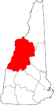
| County | Grafton |
| Town | Woodstock |
| Area | |
| • Total | 0.9 sq mi (2.3 km2) |
| • Land | 0.8 sq mi (2.2 km2) |
| • Water | 0.04 sq mi (0.1 km2) |
| Elevation | 738 ft (225 m) |
| Population (2010) | |
| • Total | 528 |
| • Density | 590/sq mi (230/km2) |
| Time zone | Eastern (EST) (UTC-5) |
| • Summer (DST) | EDT (UTC-4) |
| ZIP code | 03262 |
| Area code(s) | 603 |
| FIPS code | 33-57220 |
| GNIS feature ID | 0872411 |

North Woodstock is a census-designated place in the town of Woodstock in Grafton County, New Hampshire. It had a population of 528 at the 2010 census.[1]
It is located along the northern boundary of the town of Woodstock, adjacent to Lincoln, New Hampshire. The village is centered on the intersection of U.S. Route 3 (Main St.) and New Hampshire Route 112 (Lost River Rd./Kancamagus Highway). Interstate 93 passes through the east portion of the village. The Pemigewasset River flows past the center of North Woodstock, joined by the East Branch of the Pemigewasset and Moosilauke Brook at the southern limits of the village.
References
- ↑ United States Census Bureau, American FactFinder, 2010 Census figures. Retrieved March 23, 2011.
This article is issued from Wikipedia - version of the 6/22/2016. The text is available under the Creative Commons Attribution/Share Alike but additional terms may apply for the media files.