North Vancouver (city)
| North Vancouver | |
|---|---|
| City | |
| The Corporation of the City of North Vancouver | |
 | |
 Location of City of North Vancouver within the Metro Vancouver area in British Columbia, Canada | |
| Coordinates: 49°19′N 123°4′W / 49.317°N 123.067°WCoordinates: 49°19′N 123°4′W / 49.317°N 123.067°W | |
| Country | Canada |
| Province | British Columbia |
| Regional District | Metro Vancouver |
| Incorporated | 1907 |
| Government | |
| • Mayor | Darrell Mussatto |
| • MP | Jonathan Wilkinson (Liberal) |
| • MLA | Naomi Yamamoto (BC Liberals) |
| Area | |
| • City | 11.83 km2 (4.57 sq mi) |
| Elevation | 80 m (260 ft) |
| Population (2011) | |
| • City | 48,196 (ranked 100th) |
| • Density | 4,073.8/km2 (10,551/sq mi) |
| • Urban | 84,412 |
| Time zone | PST (UTC-8) |
| Postal code span | V7G, V7H, V7J, V7K, V7L, V7M, V7N, V7P, V7R |
| Area code(s) | 604, 778 |
| Website | City of North Vancouver official website |
|
| |
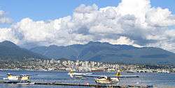
The City of North Vancouver is a waterfront municipality on the north shore of Burrard Inlet, directly across from Vancouver, British Columbia. It is the smallest of the three North Shore municipalities, and the most urbanized as well. Although it has significant industry of its own, including shipping, chemical production, and film production, the city is usually considered to be a suburb of Vancouver. The city is served by the Royal Canadian Mounted Police, British Columbia Ambulance Service, and the North Vancouver City Fire Department.
Geography

The City of North Vancouver is separated from Vancouver by the Burrard Inlet, and it is surrounded on three sides by the District of North Vancouver.
The City of North Vancouver is relatively densely populated with a number of residential high-rise buildings in the Central Lonsdale and Lower Lonsdale areas.
The city has much in common with the District Municipality of North Vancouver and West Vancouver. Together these three municipalities are commonly referred to as the North Shore. The differences between the two "North Vans" are most apparent to their residents. Other Lower Mainland residents are seldom aware of the difference between the two and refer to both as "North Vancouver".
History
Moodyville (at the south end of Moody Avenue, now Moodyville Park), is the oldest settlement on Burrard Inlet, predating Vancouver; only New Westminster is the older non-native settlement in the region. Logging came to the virgin forests of Douglas Fir in North Vancouver, as sailing ships called in to load. A water-powered sawmill was set up in the 1860s at Moodyville, by Sewell Moody. Subsequently, post offices, schools and a village sprang up. In time, the municipality of North Vancouver (which encompassed the entire North Shore from Deep Cove to Dundarave) was incorporated. In the 1880s, Arthur Heywood-Lonsdale and a relation James Pemberton Fell, made substantial investments in North Vancouver and in 1882 he financed the Moodyville investments. Several locations in the North Vancouver area are named after Lonsdale and his family.[1] The financial collapses of the 1890s and 1907 aggrieved the young city into bankruptcy. As a result of this, the separate areas of West Vancouver, and District of North Vancouver came into being, with the city holding on to only a small portion of its former area.
Part of the reason was the cost of developing raw mountainous terrain. And, originally the ocean foreshore was primarily swamp. The great distances, and large rivers to span, hindered development. Bridges were built, only to have them washed out in a few years from winter floods. The city and district built Keith Road in 1912, which undulated from West Vancouver to Deep Cove amid the slashed sidehills, swamps, and burnt stumps.
Yet the city did gain a strong foothold, with Lonsdale Avenue. Serviced by the North Vancouver Ferries, it proved a popular area. Commuters used the ferries to work in Vancouver. Street cars and early land speculation, spurred interest in the area. Streets, city blocks and houses were slowly built around lower Lonsdale. Wallace Shipyards, and the Pacific Great Eastern Railway provided an industrial base, although, the late arrival of the Second Narrows railway bridge in 1925 controlled development.

Sawmills, logging, and small farms continued in the interwar years. Yet the nearby mountains also proved to be a permanent attraction. Ski areas were set up on Grouse Mountain and Mount Seymour.
The North Vancouver mountains have many drainages: Capilano, MacKay, Mosquito, Lynn, and Seymour Rivers. The Depression again bankrupted the city, while the Second World War turned North Vancouver into the Clydeside of Canada with a large shipbuilding program. Housing the shipyard workers, provided a new building boom, which continued on through the Post-war years. By that time, North Vancouver became a popular housing area.
The area around lower Lonsdale Avenue features several open community spaces, including Waterfront Park, Lonsdale Quay, Ship Builders Square and the Burrard Dry Dock Pier.
Sites of interest
Sites of interest in the city include:[2][3][4]
- Centennial Theatre, 2300 Lonsdale Avenue
- First Church of Christ, Scientist, a local heritage site
- North Vancouver Museum & Archives, 209 West 4th Street
- Presentation House Gallery, 333 Chesterfield Avenue
- St. Edmund's Church, 535 Mahon Avenue, a local heritage site
- Trans Canada Trail Pavilion, Waterfront Park
- The Shipyards, near Lonsdale Quay, which includes Ship Builders Square and the Burrard Dry Dock Pier, on the site of the old Wallace Shipyard
- Lonsdale Quay Market, easily accessible from the Seabus. The Quay has a view of Vancouver's skyline and is locally owned and operated.
Transportation

The City of North Vancouver is connected to Vancouver by two highway bridges; the Lions' Gate Bridge and the Ironworkers Memorial Second Narrows Crossing, and also by a passenger only ferry, the SeaBus. This system as well as the bus system in North Vancouver is operated by Coast Mountain Bus Company, an operating company of Translink. The hub of the bus system is Lonsdale Quay, location of the SeaBus terminal.
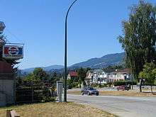
The main street in the city is Lonsdale Avenue, which begins at Lonsdale Quay and goes north to 29th Street where it continues in the District of North Vancouver, ending at Rockland Road.
Highway 1, part of the Trans-Canada Highway (often referred to as the "Upper Levels Highway") passes through the northern portion of the city. It is a freeway for its entire length within the City of North Vancouver. There are three interchanges on Highway 1 within the City of North Vancouver:
- Lynn Valley Road (Exit 19)
- Lonsdale Avenue (Exit 18)
- Westview Drive (Exit 17)
Education
Public schools are managed by the North Vancouver School District, which operates 8 high schools and 30 elementary schools shared by the city and the District of North Vancouver.
The Conseil scolaire francophone de la Colombie-Britannique operates one Francophone school in that city: école André-Piolat, which has both primary and secondary levels.[5]
There are also several independent private elementary and high schools in the area, including Bodwell High School and Lions Gate Christian Academy.
Post-secondary education is available at Capilano University in the district, as well as at Simon Fraser University and the University of British Columbia in neighbouring communities.
Demographics
According to the 2011 Canadian Census,[6] the population of North Vancouver is 48,196, a 6.7% increase from 2006. The population density is 4,073.8 people per square km. The median age is 41.2 years old, which is a bit higher than the national median age at 40.6 years old. There are 24,206 private dwellings with an occupancy rate of 94.1%. According to the 2011 National Household Survey, the median value of a dwelling in North Vancouver is $599,985 which is significantly higher than the national average at $280,552. The median household income (after-taxes) in North Vancouver is $52,794, a bit lower than the national average at $54,089.
North Vancouver has one of the highest West Asian population ratios for any Canadian city at 7.2%. The racial make up of North Vancouver is:
- 68.8% White
- 7.9% East Asian; 3.8% Chinese, 2.5% Korean, 1.6% Japanese
- 7.3% Southeast Asian; 7.0% Filipino
- 7.2% West Asian
- 3.1% South Asian
- 2.0% Aboriginal; 1.4% First Nations, 0.6% Metis
- 1.2% Latin American
- 0.8% Black
- 0.5% Arab
- 1.1% Multiracial; 1.7% including Metis
- 0.1% Other
Most residents of North Vancouver are either Christian (47.4%), or affiliated with no religion (41.7%). The remaining 10.9% of residents are affiliated with another religion.
For residents from the age of 25 years to 64; 95.3% have a high school diploma (or equivalent too), 75.6% have a post-secondary degree, and only 4.7% don't have any certificate, diploma or degree.
According to the 2001 Statistics Canada Census:
- Population: 44,303
- % Change (1996–2001): 6.8
- Dwellings: 21,217
- Area (km².): 11.95
- Density (persons per km².): 3706.2
- Has the highest level of fitness of any city in Canada.
Population estimates according to BC Stats:
| 1996+ | 1997 | 1998 | 1999 | 2000 | 2001+ | 2002 | 2003 | 2004 | 2005 | 2006 |
|---|---|---|---|---|---|---|---|---|---|---|
| 43,268 | 43,725 | 44,550 | 44,938 | 45,489 | 46,236 | 46,977 | 46,496 | 46,831 | 48,037 | 49,248 |
| Canada 2006 Census | Population | % of Total Population | |
|---|---|---|---|
| Visible minority group Source:[7] | South Asian | 1,340 | 3% |
| Chinese | 2,205 | 4.9% | |
| Black | 315 | 0.7% | |
| Filipino | 1,910 | 4.3% | |
| Latin American | 430 | 1% | |
| Arab | 90 | 0.2% | |
| Southeast Asian | 240 | 0.5% | |
| West Asian | 3,065 | 6.8% | |
| Korean | 1,160 | 2.6% | |
| Japanese | 630 | 1.4% | |
| Other visible minority | 45 | 0.1% | |
| Mixed visible minority | 340 | 0.8% | |
| Total visible minority population | 11,775 | 26.2% | |
| Aboriginal group Source:[8] | First Nations | 670 | 1.5% |
| Métis | 225 | 0.5% | |
| Inuit | 0 | 0% | |
| Total Aboriginal population | 925 | 2.1% | |
| White | 32,160 | 71.7% | |
| Total population | 44,860 | 100% | |
Languages
Mother Languages as reported by each person: Source: [9]
| Canada 2011 Census | Population | % of Total Population | % of Non-official language Population |
|---|---|---|---|
| English | 31,550 | 66.0 | N/A |
| Persian | 3,505 | 7.3 | 22.8 |
| Tagalog | 1,700 | 3.6 | 11.0 |
| Korean | 1,225 | 2.6 | 8.0 |
| Spanish | 855 | 1.8 | 5.6 |
| German | 790 | 1.8 | 5.1 |
| French | 710 | 1.5 | N/A |
Surrounding municipalities
 |
District of North Vancouver | | ||
| District of North Vancouver | |
District of North Vancouver | ||
| ||||
| | ||||
| Burrard Inlet Vancouver (via SeaBus) |
References
- ↑ Canada North Shore News
- ↑ Historic places in North Vancouver
- ↑ Attractions in North Vancouver
- ↑ Primary historic buildings in North Vancouver
- ↑ "Carte des écoles." Conseil scolaire francophone de la Colombie-Britannique. Retrieved on 22 January 2015.
- ↑ 2011 NHS/Census Profile of North Vancouver: http://www12.statcan.gc.ca/nhs-enm/2011/dp-pd/prof/details/page.cfm?Lang=E&Geo1=CSD&Code1=5915051&Data=Count&SearchText=north%20vancouver&SearchType=Begins&SearchPR=01&A1=All&B1=All&Custom=&TABID=1
- ↑ Vancouver&SearchType=Begins&SearchPR=01&B1=All&Custom=, Community Profiles from the 2006 Census, Statistics Canada - Census Subdivision
- ↑ , Aboriginal Peoples - Data table
- ↑ , Focus on Geography Series, 2011 Census-Census subdivision of North Vancouver, CY - British Columbia
External links
| Wikimedia Commons has media related to North Vancouver, British Columbia (city). |
| Wikivoyage has a travel guide for North Vancouver. |
- City of North Vancouver official website
- North Vancouver Museum & Archives
- Historic overview of North Vancouver City as part of an introduction to its Official Community Plan
Municipalities of Metro Vancouver | |
|---|---|
| Population over 500,000 | |
| Population over 100,000 | |
| Population over 50,000 | |
| Population over 10,000 | |
| Population under 10,000 | |
| Unincorporated areas | |
| |
| Subdivisions | 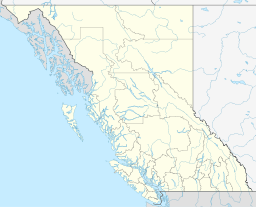 | |
|---|---|---|
| Communities | ||
| Metro areas and agglomerations | ||
| Cities |
| |
| ||