North Shore Channel

The North Shore Channel is a drainage canal built between 1907 and 1910 to flush the sewage-filled North Branch of the Chicago River down the Chicago Sanitary and Ship Canal.[1] The sewage carrying duty has been largely taken over by the Chicago Deep Tunnel, but there are still occasional discharges due to heavy rains.[2]
Geography
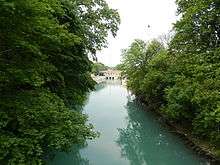
The North Shore Channel flows from Lake Michigan to the North Branch of the Chicago River.[3]
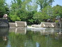
A sluice gate usually prevents the canal from back-draining out to Lake Michigan in Wilmette, although the gate must be opened occasionally to prevent downstream flooding.[1] The north end of the channel is near the Bahá'í House of Worship. The channel flows southwest, and then south, through or near Wilmette, Evanston, Skokie, and Lincolnwood, and into Chicago. The south end of the channel flows into the North Branch at approximately 5100 north and 3000 west in the Chicago street address numbering system. Chicago's only waterfall within the city limits, which looks like a concrete spillway, is in River Park, where the upper North Branch drops about 4 feet (1.2 m) through a dam into the confluence.[4]
In 1999, the system of which the canal is a part was named a Civil Engineering Monument of the Millennium (as part of the Chicago wastewater system) by the American Society of Civil Engineers (ASCE).[5]
Wildlife
Surrounded by parks and steep, wooded banks, the canal provides a corridor for local wildlife.[1] Wildlife includes, but is not limited to, beaver, coyote, carp, and ducks.
Recreation
Since the water quality improvement, fishing has become possible in the canal.[6] Bass and croppie are abundant, especially at the confluence of the canal and the North Branch of the Chicago River, where the waterfall aerates the water.[7] Canoeing and kayaking are allowed, with several put-in points along the length.[8] In addition to water navigation, both walking and biking paths follow along nearly the entire length of the canal.[9] The Evanston-Wilmette Community Golf Course ("Canal Shores") plays along a stretch of the canal of about 1 mile (1.6 km), and two par-3 holes play across it.[10]
References
- 1 2 3 Hill, Libby (2000). The Chicago River, A Natural and Unnatural History. Chicago: Lake Claremont Press. pp. 139–151. ISBN 1-893121-02-X.
- ↑ "CSO - Operational and Maintenance Plan Summary". Village of Willmette. Retrieved 23 June 2014.
- ↑ "Where is the Chicago River?", Friends of the Chicago River. Retrieved August 18, 2014. "The Upper North Branch then continues to flow south through Niles into the city of Chicago, where it combines with the North Shore Channel at River Park and forms the North Branch of the Chicago River. The North Shore Channel starts in Wilmette flows through Skokie, Evanston and Lincolnwood to Chicago."
- ↑ "Chicago River Water Trails", Openland. Retrieved August 23, 2014.
- ↑ American Society of Civil Engineers. "Chicago Wastewater System". Retrieved 15 May 2011.
- ↑ "10 Places to Catch a Fish in Chicago". World Fishing Network.
- ↑ "River Park". http://www.chicagoparkdistrict.com/parks/River-Park/#.U6gYLLEtpI0. Chicago Park District. External link in
|website=(help); - ↑ Author unknown (date unknown). North Shore Channel put-ins. Retrieved from http://www.paddleaway.com/put_ins?river_id_param=61.
- ↑ Raz, Katherine (2010). "Best Alternative to the Lakefront Path". Chicago Reader. Retrieved 2012-12-21.
- ↑ Evanston Wilmette Community Golf Course. "Scorecard". Retrieved 12 February 2014.
Coordinates: 42°02′28″N 87°42′35″W / 42.04111°N 87.70972°W