Cyclone Xaver
 Surface pressure chart 12:00 UTC 5 December 2013 | |
| Type | European windstorm, extratropical cyclone, winter storm |
|---|---|
| Formed | 4 December 2013 |
| Dissipated | 10 December 2013 |
| Lowest pressure | 962 mb (28.41 inHg) |
| Highest winds |
|
| Highest gust |
142 mph (229 km/h), Aonach Mòr, Scotland |
| Areas affected |
|
Cyclone Xaver (DMI: Bodil, SMHI: Sven)[2][3][4] also known as the North Sea flood or tidal surge of 2013, was a winter storm that affected northern Europe. Force 12 winds and heavy snowfall were predicted along the storm's path, and there were warnings of a significant risk of storm surge leading to coastal flooding along the coasts of the North and Irish Seas.
Names

The Free University of Berlin gave the storm the name Xaver (a German form of the name Xavier), which had been previously given to the Berit storm of 2011. The Danish Meteorological Institute following a decision that the institute would name storms affecting Denmark following the St. Jude storm (which had retroactively been given the name Allan) named the storm Bodil.[5] In Poland, the storm is named Ksawery, which is the Polish equivalent of Xaver.[6] The Swedish Meteorological Institute gave the storm the name Sven, after the name day of 5 December.[5] In the Netherlands the storm was known as the "Sinterklaasstorm", as 5 December is traditionally celebrated as St. Nicholas Eve in the country.[7] Twitter users in the UK were using the hashtags #scotstorm, #Xaver and #UKstorm. The European Windstorm Centre, a UK-based forecaster, gave the storm the name Cameron.[8]
Meteorological history
Xaver formed to the south of Greenland on 4 December, and explosively deepened as it moved east to pass the north of Scotland on 5 December.[9] Over the next few days Xaver moved over Southern Norway and Sweden intensifying further, reaching its lowest pressure over the Baltic Sea.[9]
Forecast

.jpg)
The low pressure system formed on 4 December off the west coast of Iceland and is expected to deepen explosively overnight. The UK Met Office issued an amber warning over Scotland and northern parts of England, where wind gusts may reach 90 miles per hour (145 km/h).[10] On 4 December the Environment Agency released a warning to communities along the East Coast of England to prepare for the most serious tidal surge in 30 years, with a significant threat of coastal flooding between 5–7 December.[11]
In the Netherlands, the provinces of Friesland, Groningen and North Holland were placed on Red Alert. Winds of Force 9 – 11 were forecast. The IJsselmeer and Waddenzee areas were also covered by the Code Red alert.[12]
Force 12 gusts are expected in Denmark.[13] In Sweden, the local meteorological institute has given a level 2 warning for central parts of the country due to heavy snowfall and formation of snow drifts.[14]
An extreme weather warning has been given to coastal areas of northwestern Germany due to 85 miles per hour (137 km/h) wind gusts.[15] Meteorologists in Germany likened the storm's development to that seen during the North Sea flood of 1962 in which 340 people lost their lives in Hamburg, saying that improvements in sea defences since that time would withstand this storm surge.[16]
Preparation
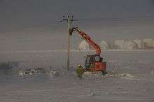
The oil platform Buchan Alpha, northeast of Aberdeen was evacuated due to the upcoming storm.[17] East Coast trains announced Thursday 4 December that they expected to run a revised timetable the next day due to the storm.[18] First ScotRail planned to not run trains before 7:00 am on 5 December and expected around 20 routes to be closed, with Network Rail advising passengers to expect delays in Scotland and northern and eastern England.[19] In Leeds roads surrounding the Bridgewater Place tower were closed following a coroners ruling that the surrounding roads should be closed when wind gusts reach 45 miles per hour (72 km/h), following the death of a man after a truck was blown over by freak winds in 2011.[20] People living in Great Yarmouth were told to prepare to evacuate in case the River Yare flooded as a result of the storm.[21] In London, the Thames Barrier was closed to protect the capital from surges along the River Thames,[22] closing for the 126 time in its 31-years of service.[23]
Impact
Storm Xaver brought wind gusts up to 142 mph to upland Scotland, though the lowlands in the U.K. and mainland Europe also saw some strong winds. A large area along the European coast from the Netherlands to Denmark saw gusts up to 81 mph with one location on the Danish-German border peaking at 98 mph.[24]
Winds brought down a life size Tyrannosaurus rex model at Klimahaus Bremerhaven.[24][25]
Transport
Rail
In Scotland, at 8 a.m. on 5 December 2013 Glasgow Central station was evacuated after the glass roof was broken by flying debris. ScotRail later cancelled all services in Scotland due to debris including "trampolines, hay bales and trees" falling on the train lines.[1] Rail Net Denmark announced that all rail transport would come to a halt for the afternoon of 5 December.[26] This is the first time all trains in the country have been cancelled. All rail services were cancelled in the Swedish region of Skåne.[27] Rail services across Northern Germany were affected with cancellations across Schleswig-Holstein.[27] The East Suffolk Line (South East England/East Anglia) was closed due to flooding at six locations between Lowestoft and Haddiscoe. Services between Lowestoft and Beccles had not been restored as of 12 December 2013.[28]
Road
Friarton Bridge, Perth, Scotland was closed due to an overturned lorry as a result of the storm.[1] The Redheugh Bridge between Newcastle and Gateshead was also closed due to an overturned lorry, leaving the route closed and traffic diverted,[29] Forth Bridge was also closed due to luton van being driven onto the bridge and then abandons the van, [30][31] Tay and Skye bridges were fully closed. Elsewhere, the Ouse Bridge which carries the M62 motorway over the river Ouse was closed in both directions following a lorry overturning in the high winds.[32] In Stavanger, Norway, on the evening of 5 December 2013 road traffic and pedestrians were not allowed to the city centre due to the risk of house elements being blown down.
Sea
The Isle of Man Steam Packet Company cancelled ferries to and from Douglas due to winds forecast to reach Force 9.[33] in Stavanger, Norway several local ferry services were cancelled.
Air
Glasgow, Edinburgh and Aberdeen airports were affected by the storm. With an Easyjet flight to Edinburgh struck by lightning and unable to land diverted to Newcastle.[27][34] Another flight from London attempted to land at both Glasgow and Edinburgh before diverting to Manchester.[35] Further south in England video of planes attempting to land at Birmingham Airport in cross winds was posted on the internet, with several flights being forced to re-route to other airports, after failing to land.[36]
In Norway, Stavanger Airport was closed to inbound and outbound flights by the storm winds.[37] Stavanger's major helicopter hub was closed and all the crafts grounded, pausing in service for North Sea oil platforms.
In Sweden Gothenburg's Göteborg Landvetter Airport and Malmö Airport saw planes grounded.[27] Amsterdam Airport Schiphol, Hamburg Airport and Berlin Tegel all reported some disruption.[27] Flights to and from Denmark were cancelled, with Billund Airport, Aalborg Airport and Copenhagen Airport all closed.
Energy disruption
20,000 houses lost power in Scotland.[38] In Northern Ireland, 6,500 houses lost power.[39] In the north of England 20,000 homes were without power across Cumbria and Teesside.[40] Northern Powergrid estimated a total of 135,000 properties across the North East, Yorkshire and North Lincolnshire were subject to power disruptions during the storm.[41] Sweden saw a peak of 50,000 homes without power.[42] In Poland, blackout hit 400,000 households.[43]
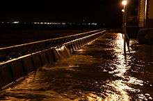
Storm surge
Xaver brought a significant storm surge to Northern Europe with the Environment Agency in England reporting 1,400 homes flooded in England and Wales.[44][45]
Irish Sea
In the Irish sea flooding was most severe along the north coast of Wales and west coast of England, as winds drove the sea towards the southwest corner of the sea, with onshore winds driving large waves towards the coast. On Thursday, hundreds of people were evacuated from Rhyl, Denbighshire when high tides caused flooding in several streets.[46] North Wales saw a total of 300 homes flooded,[44] mostly in Rhyl with homes also flooded in Kinmel Bay and Llanddulas in Conwy.[47]
Flooding in New Brighton, Merseyside, left cars and businesses flooded at Marine Point and Kings Parade, with police warning the public to keep away from the promenade and Vale Park.[48] In Whitehaven, Cumbria the 400-year-old stone built Old Quay dating from 1634 was damaged.[49] In Blackpool the town's North Pier was severely damaged by the high waves, which included structural damage to the supporting piles.[50] Water levels in both New Brighton and Blackpool were the highest since 1987.[51]
Atlantic coasts
On the Scottish west coast the main street and esplanade of Oban were flooded.[52] In Northern Ireland the town of Portstewart on the north coast saw waves crashing over the promenade and a children's playground flooded.
North Sea
On entering the North Sea, the storm surge propagated with the tide along the east coast of Scotland and England from north to south, then continued anticlockwise around the southern North Sea coast to the Netherlands, Germany and Denmark.[53][54]
Surges of comparable magnitude to this event and 1953 are not infrequent in the North Sea, 15 are listed to have occurred between 1883 and 1979.[55] The Environment Agency described the storm surge as the most serious in 60 years,[56] with water heights exceeding those of the 1953 flood and 1978 North Sea storm surge at localised points in North Shields and the Humber Estuary.[55][57]
| Location | country | Height in metres above datum | Time (UTC) and date |
|---|---|---|---|
| Lerwick | | 1.19 | 12:15 5/12/13 |
| Wick | | 2.07 | 12:45 5/12/13 |
| Aberdeen | | 2.65 | 15:00 5/12/13 |
| Leith | | 3.42 | 15:15 5/12/13 |
| North Shields | | 3.58 | 16:15 5/12/13 |
| Whitby | | 3.77 | 17:15 5/12/13 |
| Immingham | | 5.80 | 19:00 5/12/13 |
| Cromer | | 3.43 | 19:45 5/12/13 |
| Lowestoft | | 2.97 | 22:30 5/12/13 |
| Harwich | | 3.28 | 01:45 6/12/13 |
| Sheerness | | 3.93 | 02:00 6/12/13 |
| Herne Bay | | 4.20 | 01:36 6/12/13 |
| Dover | | 4.72 | 00:45 6/12/13 |
| Ostend | | 3.75 | 02:00 6/12/13 |
| Borkum | | 3.53 | 00:20 6/12/13 |
| Heligoland Binnenhafen | | 3.32 | 01:08 6/12/13 |
| Cuxhaven | | 4.28 | 01:27 6/12/13 |
| Hirtshals | | 1.32 | 12:00 6/12/13 |
| Gothenburg Torshamnen | | 1.10 | 15:43 6/12/13 |
England
The surge caused the River Tyne in Newcastle to breach its banks and the Tees to overtop its banks into the village of Port Clarance on the north bank causing a major power outage on the south bank of the river, Middlesbrough. It caused a major breach in a sea wall on Greatham Creek alongside Billingham docks thereafter repaired using RAF Chinook helicopters.[58][59]
Floods in Whitby to the south of the North East region saw an electrical substation short out or 'explode'.[60] and 200 homes left underwater.[44] Further along the Yorkshire coast Scarborough and Bridlington also saw flooding.
Around the Humber estuary, Spurn Point nature reserve was closed in anticipation of the surge arrival. In Cleethorpes high water brought limited flooding along the promenade, though to the south of the resort holiday areas were affected. In adjoining Grimsby water overwhelmed the dock gates,[61] the water was able to be contained within the docks which had been run down in anticipation, and did not flood into the town.[62] As the water was funnelled up the Humber estuary the surge level increased. Humberside Police declared a state of emergency as the River Humber reached a record height of 5.8 m in the city of Hull.[63] To the east of the city the village of Paull flooded. Within Hull city the Hull Tidal Barrier was lowered, protecting large areas of the city, however some flooding occurred in the city centre, Victoria Docks, and Hessle foreshore to homes and business properties. A major flooding event occurred in west central Hull due to the surge overtopping the Albert Dock;[64][65] the A63 road through the city was closed until midday 6 December due to water covering the carriageway. Humberside Police released aerial footage from further up the Humber showing the large extent of flooding across North Lincolnshire and East Yorkshire, along the River Trent and Ouse.[66] Altogether the East Riding's Council counted 210 residential properties and 45 commercial properties flooded.[67] 500 properties were flooded in North Lincolnshire across 11 villages.[68]
South along the Lincolnshire coast flooding and damage were less severe, likely due to the lessening winds which were blowing offshore. The grey seal colony at Donna Nook in Lincolnshire was inundated, wardens prepared by opening gates in the fences to allow the seals to escape the flood into the dunes and farmland.[69] Mablethorpe reported debris, and in Skegness some damage to coastal kiosks occurred,[70] south of the town to the visitor's centre at Gibraltar Point nature reserve was damaged by the surge.[71]
In Boston, Lincolnshire flood defence walls were overtopped as the surge rose to levels above those seen in 1953. The Haven in the town flooded St Botolph's Church, damaging building maintenance equipment in the cellar. 300 homes were flooded in the town.[45] Boston Borough Council released their CCTV footage of the defences being overtopped and resultant flooding.[72]

On the Norfolk coast the lifeboat station at Wells-next-the-sea was flooded.[73] Cromer pier suffered significant damage as waves rebounded off the seawall damaging the deck, along the seafront beach huts were destroyed littering the coast to Overstrand with debris.[73] In Happisburgh sections of cliff were eroded leaving a home hanging over the edge and uninhabitable; at Hemsby homes in the Norfolk sand dune coastline were undermined and fell into the sea.[73]
In Lowestoft, Suffolk, the main harbour area, the railway station and the southern section of the main town centre were flooded, affecting local businesses including the Peanut Pot Noodle. Both bridges that connect north and south Lowestoft were underwater for a few hours. Two short dense urban roads were flooded.[74][75][76]
In Suffolk Coastal, the villages of Snape on the Alde-Ore estuary and Waldringfield on River Deben saw 38 properties flooded.[77]
Belgium and Netherlands
In Belgium, Bredene municipality evacuated 2,083 residents in the district between Sas Slijkens and Spuikom along the Bruges-Ostend canal.[78]
The storm passed without any major damage along the Belgian coast, in Ostend high water measured at 6.33 meters TAW (height above mean low tide), the largest surge to reach the Belgian coast since 1953.[79]
In the port of Antwerp, the C Ladybug came adrift, and was blown across the dock before being re-birthed with the help of two tugs.[80]
In the Western Scheldt shipping was slowed between Vlissingen and Deurgancdok, Antwerp after 5 containers fell off a ship, 4 were empty and one loaded with tapioca, they were eventually washed up near Terneuzen.[80]
In the Netherlands, the water reached the highest level since the North Sea flood of 1953 at 3.99m above normal sea level. In 1953, the water rose to 4.55m on the night of 1 February, and dykes broke in at least 90 places resulting in the worst natural disaster in the Netherlands in the 1900s. The Eastern Scheldt storm surge barrier closed all its 62 locks on Thursday night and several areas around Rotterdam experienced some flooding.[81] Minor flooding was also reported in Dordrecht and Vlaardingen.[82]
France
Winds Xaver proved weaker than expected on the north coast of France near Dunkirk. The maximum premium observed at low tide in Dunkirk was about 2.40 meters, but other important differences between the observed water heights and predicted water heights were measured at Calais and Boulogne-sur-Mer.[83]
Germany
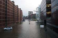
German authorities reported waves up to six metres high, which were the second highest on record since 1825.[84] Some parts of Hamburg flooded, but the city saw no injuries or loss of life reported. The city closed all 38 of its flood gates, which lessened the storm’s impact. The gates protect nearly $14 billion in commodities according to research from the Helmholtz-Zentrum Geesthacht Center for Materials and Coastal Research.[24]
Denmark and Sweden
In Sweden water levels were higher than expected on the western Scania coast, at 150 cm over normal, registering up to 157 cm above mean at Viken, Höganäs Municipality.[85] Citizens were advised to stay indoors [86]
In Denmark, the population was advised to remain indoors. Children were sent home from school before normal school finishing time and some parents were trapped at their place of work. The water levels were higher than expected. Holiday homes in Nørlev Strand were left undermined as the storm eroded sand dunes, along the Jutland coast.[87]
Casualties
Five people were killed in Poland,[88] including three people in a car when a tree struck it in Poraj, northern Poland. The storm also caused two deaths in the UK[89] and one in Denmark.[90] In Sweden a total of seven people died.[43]
Aftermath

The BBC addressed criticism after it suspended the regular evening news to cover the death of Nelson Mandela, while communities along the coast were still preparing for flooding.[91] Under the Flood and Water Management Act 2010, local authorities normally investigate flooding in their boundaries, however Alun Davies the Welsh Assembly Minister for Natural Resources and Food, instructed Natural Resources Wales to co-ordinate the inquiry in Wales as one comprehensive report.[47]
Member of Parliament for Waveney, Peter Aldous initiated a debate in the House of Commons of the United Kingdom to discuss what went well and what can be improved on a national level in regards to future flood defences/preparations, etc. Within his constituency is the town of Lowestoft, which was affected by the storm. "There is a strong sense in these communities that Parliament has not yet considered properly this narrowly averted national crisis. We need to establish what went right and also what can be improved upon."[92] He also later stated "It is wrong to dismiss these floods as a once in a 500-year occurrence. There were floods six years ago [In this context, note the floods in 2007 didn't affect Mr Aldous' home constituency, but Mr. Aldous is making the point that the risk of flooding is a national problem that needs addressing and not just a regional issue. The flood of 2007 caused £6billion worth of damage]. I think with rising sea levels these are going to be a thing of the future and we do need to be looking at protecting the most vulnerable areas."[93]
Credit Suisse made initial estimates on the cost of damage ranging between €1.4 billion and €1.9 billion.[94] The catastrophe modelling company AIR Worldwide estimated wind losses from the storm would be between €700 million and €1.4 billion.[95] The company said that Xaver's wind impact was likely to be less than that of the St. Jude storm, as it had lower wind speeds, and expected structural damage from high winds to be more limited.[84] Perils AG the catastrophic insurance data company gave an initial estimate of €680 million for insured property losses to the insurance industry on 16 January 2014.[96]
The chief executive of the United Kingdom's Environment Agency said in January 2014 that the storm surge may change the coastline of the UK permanently, as the Agency weighs up whether to abandon some flooded areas permanently to the sea. 373 acres in East Anglia were still underwater in January and some defences and freshwater habitats may not be reinstated along the Norfolk and Suffolk coasts.[97][98] In February 2014 the Environment Agency announced that it had repaired 7 km of defences along the Humber Estuary from Barton upon Humber to Goxhill Haven, with work to the west of Barton due to be completed by March 2014. The agency secured £1.5 million to complete the works after the highest surge ever recorded in the estuary brought destruction to defences along the south Humber bank from Whitton to East Halton.[99]
Subsequent weather

Through the winter, subsequent Atlantic winter storms in Europe brought three storms to the UK around Christmas, with Cyclone Dirk bringing flooding and transport disruption prior to the holiday. Further storms in the New Year, Cyclones Anne and Christina brought further coastal flooding to the South West of England and the Welsh coast, with heavy rains leading to flooding and stormy seas leaving at least seven people dead and more than 1,700 homes and businesses flooded in England in the period between Christmas and following the Epiphany (holiday) week.[100][101]
Parts of England had the wettest January 2014 from when records began more than 100 years before. In January 2014 more than 30 flood warnings were in place and some 160 flood alerts.[102]
In February 2014 more than 200 properties were evacuated in Somerset and Devon. Police used megaphone warnings from a helicopter to urge residents in the flood-stricken Somerset Levels to leave their homes. Winds of more than 90 mph were recorded.[103]
In response to the coastal flooding in December and subsequent stormy weather the Government enacted the Bellwin scheme. In February David Cameron pledged to provide £100 million to tackle the aftermath of the floods.[103] An extra £30 million was pledged for flood repairs and maintenance on top of the £100 million. Of the £130 million total, £30 million is to be spent in 2014/15 and £100 million in 2015/16. 42 new flood defence schemes were planned for 2014/15.[104]
The UK's National Weather Service The Met Office issued severe weather warnings in February for further storms affecting the United Kingdom.[105] Much of Europe felt the effects of these Atlantic storms. There was flooding in France, large snowfalls in Austria and Slovenia and large waves in Portugal and Spain.[106]
See also
- 1978 North Sea storm surge
- Gale of January 1976, widely known as the "Capella" storm in Germany and the "Ruisbroek flood" in Belgium
- St. Jude storm - the previous storm to affect north west Europe
References
- 1 2 3 "Storm with gales of up to 142mph batter Scotland causing disruption". STV. 4 December 2013. Retrieved 5 December 2013.
- ↑ "Archived copy". Archived from the original on 13 December 2013. Retrieved 2013-12-05.
- ↑ "Stormen hedder Bodil". DMI. Retrieved 17 December 2013.
- ↑ Sweden weather | Weather | SMHI. Smhi.se. Retrieved on 4 February 2014.
- 1 2 Brandt, Anders (4 December 2013). "Bodil, Sven, Xaver, Bud - kær storm har mange navne". TV2 (in Danish). Retrieved 4 December 2013.
- ↑ Gazeta.pl Archived 29 November 2014 at the Wayback Machine.
- ↑ "Hulpdiensten op scherp voor storm". De Telegraaf. 4 December 2013. Retrieved 5 December 2013.
- ↑ European Windstorm Centre. Sites.google.com. Retrieved on 4 February 2014.
- 1 2 "Extratropical Cyclone Xaver". AIR worldwide. 12 December 2013. Retrieved 28 December 2013.
- ↑ "High wind warning for Scotland upgraded by Met Office". BBC. 4 December 2013. Retrieved 4 December 2013.
- ↑ "Communities urged to prepare for worst east coast tidal surge in 30 years". Environment Agency. 4 December 2013. Archived from the original on 7 December 2013. Retrieved 4 December 2013.
- ↑ "Code rood voor storm" [Code Red before storm] (in Dutch). De Telegraaf. Retrieved 5 December 2013.
- ↑ "Varsler: DMI". DMI. 4 December 2013. Retrieved 4 December 2013.
- ↑ "SMHI varningar". SMHI. 4 December 2013. Retrieved 4 December 2013.
- ↑ "Deutscher Wetterdienst - warnings". Deutscher Wetterdienst. 4 December 2013. Retrieved 4 December 2013.
- ↑ "Gale-Force Winds: Germans Brace for Major Winter Storm". Der Spiegel. 4 December 2013. Retrieved 5 December 2013.
- ↑ "Workers off Talisman Sinopec oil platform Buchan Alpha over bad weather forecast". BBC. 4 December 2013. Retrieved 4 December 2013.
- ↑ Clapham, Lucy (4 December 2013). "Risk of flooding along Norfolk coast and severe weather warnings issued across the east as winds of up to 80mph set to batter region". Eastern Daily Press. Retrieved 4 December 2013.
- ↑ "Wind and coastal flood warning for Scotland and England". BBC News. 4 December 2013. Retrieved 4 December 2013.
- ↑ "Roads around Bridgewater Place to be closed due to wind". BBC News. 4 December 2013. Retrieved 4 December 2013.
- ↑ "People in Great Yarmouth have been warned to be prepared to evacuate their homes". Eastern Daily Press. 4 December 2013. Retrieved 5 December 2013.
- ↑ "UK storm 'to bring flooding and strong winds'". BBC News. 4 December 2013. Retrieved 5 December 2013.
- ↑ Pentland, William (8 December 2013). "What London Would Have Looked Like On Friday Without Flood Defenses". Forbes. Retrieved 13 December 2013.
- 1 2 3 Kahn, Brian (6 December 2013). "Xaver Packs Punch in Europe But Barriers Hold". AP via Kitaspun. Retrieved 25 January 2014.
- ↑ "Unser Dino hat den Orkan letzte Nacht leider nicht heil überstanden…". Facebook timeline: Klimahaus Bremerhaven. Retrieved 25 January 2014.
- ↑ Ertman, Berit (5 December 2013). "Banedanmark lukker for al togdrift". Jyllands Posten (in Danish). Retrieved 5 December 2013.
- 1 2 3 4 5 "Deadly storm and tidal surge batter northern Europe". BBC News. Retrieved 8 December 2013.
- ↑ "Storm-hit Lowestoft to Beccles train line still closed". BBC News Online. Retrieved 12 December 2013.
- ↑ Lawson, Ruth (5 December 2013). "Watch: Redheugh Bridge closed after lorry blown over". Chronicle Live. Retrieved 6 December 2013.
- ↑ ‘Reckless’ man abandons van on Forth Road Bridge - Edinburgh Evening News. Edinburghnews.scotsman.com (6 December 2013). Retrieved on 4 February 2014.
- ↑ BBC News - CCTV shows van blown around on Forth Bridge. Bbc.co.uk. Retrieved on 4 February 2014.
- ↑ "WEATHER UPDATES: M62 west of Hull closed after lorry crashes on Ouse Bridge". Hull Daily Mail. 5 December 2013. Retrieved 6 December 2013.
- ↑ "Severe gales cancel Isle of Man ferry sailings". BBC News Online. Retrieved 5 December 2013.
- ↑ Emanuel, Louis (5 December 2013). "Flight from Bristol hit by lightning and diverted from Edinburgh to Newcastle". Bristol Post. Retrieved 8 December 2013.
- ↑ "Like a roller coaster: EasyJet plane from London aborts landings at Glasgow and Edinburgh". Herald Scotland. 5 December 2013. Retrieved 8 December 2013.
- ↑ "UK weather: Dramatic footage shows planes unable to land at Birmingham Airport amid gale-force winds". Metro. 5 December 2013. Retrieved 8 December 2013.
- ↑ "Storm cancels flights, ferries". Newsinenglish.no. 5 December 2013. Retrieved 6 December 2013.
- ↑ "Gales hit UK: 20,000 without power in Scotland". ITV. 4 December 2013. Retrieved 5 December 2013.
- ↑ "Strong winds leave 6,500 customers without power says NIE". BBC. 4 December 2013. Retrieved 5 December 2013.
- ↑ "Fierce storms force mass evacuations in England as man is killed". BBC News. 6 December 2013. Retrieved 8 December 2013.
- ↑ "All customers who lost power in Thursday's storm have their service restored". Northern Powergrid. 8 December 2013. Retrieved 9 December 2013.
- ↑ "Tiotusentals hushåll utan ström". SVT (in Swedish). 6 December 2013. Retrieved 7 December 2013.
- 1 2 "Europe winter storm claims 10 lives". Yahoo! News. 7 December 2013.
- 1 2 3 "Windstorm Xaver". RMS. 19 December 2013. Retrieved 28 December 2013.
- 1 2 "Clean up of tidal surge as communities count the cost". ITV. 9 December 2013. Retrieved 9 December 2013.
- ↑ "North Wales coast escapes fresh flooding overnight". BBC. Retrieved 6 December 2013.
- 1 2 "Rhyl floods probe to improve future resilience, says minister". BBC News. 11 December 2013. Retrieved 11 December 2013.
- ↑ "Flooding in New Brighton leaves cars and shops under water". BBC News. 5 December 2013. Retrieved 6 December 2013.
- ↑ "400-year-old sea wall the biggest west Cumbrian storm casualty". ITV. 5 December 2013. Retrieved 6 December 2013.
- ↑ Berentzen, Paul (7 December 2013). "£1m damage as storms devastate North Pier". Blackpool Gazette. Retrieved 8 December 2013.
- ↑ Sibley, Andrew; Cox, Dave; Titley, Helen (February 2015). "Coastal flooding in England and Wales from Atlantic and North Sea storms during the 2013/2014 winter". Weather. 70 (2): 62–70. Bibcode:2015Wthr...70...62S. doi:10.1002/wea.2471. Retrieved 14 February 2015.
- ↑ "Winds batter West Highlands and islands". The Oban Times. 5 December 2013. Retrieved 6 December 2013.
- ↑ "Storm surge warning for mainland Europe". BBC Weather. 5 December 2013. Retrieved 28 December 2013.
- ↑ "Case Studies: Floods and Flooding". Met Office. Retrieved 5 December 2013.
- 1 2 Steers, J. A.; Stoddart, D. R.; Bayliss-Smith, T. P.; Spencer, T.; Durbidge, P. M. (July 1979). "The Storm Surge of 11 January 1978 on the East Coast of England". The Geographical Journal. 145 (2): 192–205. doi:10.2307/634386. JSTOR 634386.
- ↑ "16:30 Update: Environment Agency issues further severe flood warnings from North Lincolnshire to Kent". Environment Agency. 5 December 2013. Retrieved 22 February 2014.
- 1 2 "Sea Level Station Monitoring Facility". UNESCO Intergovernmental Oceanographic Commission. Retrieved 14 December 2013.
- ↑ "Hartlepool power station December 2013 monthly report" (PDF). EDF Energy. January 2014. Retrieved 2 April 2014.
- ↑ "Flood defence repairs continue". Hartlepool Mail. 9 December 2013. Retrieved 2 April 2014.
- ↑ "Reports of sub station explosion in Whitby". ITV Calendar. 5 December 2013. Retrieved 6 December 2013.
- ↑ "PHOTOS: Sea water breaks defences on Humberside". ITV Calendar. Retrieved 6 December 2013.
- ↑ "Dock's actions praised or 'whole of West Marsh would have been under water'". Grimsby Telegraph. Retrieved 8 December 2013.
- ↑ "Tides hit record levels in Hull". ITV Calendar. 5 December 2013. Retrieved 6 December 2013.
- ↑ "Agency urged to fix flaw in Hull's flood defences". Yorkshire Post. 4 February 2014.
- ↑ Young, Angus (4 February 2014). "Hull floods report: 'Raise level of Albert Dock defences'". Hull Daily Mail.
- ↑ "Hull and north Lincolnshire floods clean-up begins". BBC News. 6 December 2013. Retrieved 6 December 2013.
- ↑ "Council continues flood recovery:Updated 12 December". East Riding Council. 12 December 2013. Retrieved 13 February 2014.
- ↑ "Latest flooding update - the A1077 is to be reopened". North Lincolnshire Council. 9 December 2013. Retrieved 11 December 2013.
- ↑ "Donna Nook seals to be protected against storms". BBC News. 5 December 2013. Retrieved 7 December 2013.
- ↑ "Fire crew attend Skegness Pier flooding". Skegness Standard. 6 December 2013. Retrieved 6 December 2013.
- ↑ "Gibraltar Point Visitor Centre inundated by tidal surge". Skegness Standard. 6 December 2013. Retrieved 6 December 2013.
- ↑ "Boston Flood - December 5, 2013". Boston Borough Council. Retrieved 17 December 2013.
- 1 2 3 "In pictures: Norfolk tidal surge aerial views". BBC News. 11 December 2013. Retrieved 12 December 2013.
- ↑ "Lowestoft counts cost of tidal surge". Lowestoft Journal. 7 December 2013. Retrieved 13 December 2013.
- ↑ "Photo gallery: Lowestoft recovers from tidal surge". Lowestoft Journal. 6 December 2013. Retrieved 13 December 2013.
- ↑ "Aftermath of Lowestoft Floods lives on". Lowestoft Journal. 6 January 2014. Retrieved 8 January 2014.
- ↑ "Suffolk community drop-ins after the surge". Environment Agency. 13 February 2014. Retrieved 20 February 2014.
- ↑ "Evacuatie Voor Sinterklaasstorm". VTM Nieuws. 5 December 2013. Retrieved 15 December 2013.
- ↑ "06 December 2013, Storm Xaver is over". Management Unit of the North Sea Mathematical Models. 6 December 2013. Retrieved 15 December 2013.
- 1 2 "Vijf containers even op drift op de Schelde". Het Belang Van Limburg. 5 December 2013. Retrieved 15 December 2013.
- ↑ "Deadly storm and tidal surge batter northern Europe". BBC. Retrieved 6 December 2013.
- ↑ "Windstorm Xaver: Event Summary". Guy Carpenter. 9 December 2013. Retrieved 25 January 2014.
- ↑ SHOM (10 December 2013). "Impact of the storm Xaver in the North Sea on the sea level in the Nord-Pas de Calais region". refmar.shom.fr. Retrieved 14 April 2014.
- 1 2 "Flood defenses helped limit damage from northern Europe storm". Canadian Underwriter. 11 December 2013. Retrieved 7 January 2014.
- ↑ "Mycket högt vattenstånd efter stormen". Länsstyrelsen Skåne. 6 December 2013. Retrieved 20 December 2013.
- ↑ Skåningar uppmanas att om möjligt stanna inomhus ikväll - Länsstyrelsen Skåne. Lansstyrelsen.se (5 December 2013). Retrieved on 4 February 2014.
- ↑ Eggert, Morten (8 December 2013). "Offer for Bodil: Købte huset 15. august - nu er det væk". Berlingske. Retrieved 5 October 2014.
- ↑ "Storm Xaver blizzards claim more lives in Poland". Euronews. 8 December 2013.
- ↑ BBC News - Driver killed after HGV blown over in storms near Bathgate. Bbc.co.uk (5 December 2013). Retrieved on 4 February 2014.
- ↑ "Deadly storm and tidal surge batter northern Europe". BBC News. 6 December 2013.
- ↑ "BBC News chief defends Mandela coverage". BBC News. 9 December 2014. Retrieved 2 March 2014.
- ↑ "There is a strong sense Parliament has not yet considered properly this narrowly averted national crisis" - MP secures Commons debate on flood - News. Lowestoft Journal. Retrieved on 4 February 2014.
- ↑ "Suffolk MP hits out at environment secretary in statement about the floods - News". Retrieved 4 February 2014.. Lowestoft Journal. Retrieved on 4 February 2014.
- ↑ "Credit Suisse puts windstorm Xaver insured loss at €1.4bn to €1.9bn". Artemis. 12 December 2013. Retrieved 13 December 2013.
- ↑ "AIR Estimates Losses from European Windstorm Xaver at Between EUR 700 Million and EUR 1.4 Billion". Insurance News Daily. 12 December 2013. Retrieved 13 December 2013.
- ↑ "PERILS PUTS INITIAL LOSS ESTIMATE FOR WINDSTORM XAVER AT EUR 680 MILLION" (PDF). Perils AG. 16 January 2014. Retrieved 1 February 2014.
- ↑ Hope, Christopher (24 January 2014). "Parts of Britain to be abandoned to the sea after December tidal surge". The Telegraph. Retrieved 24 January 2014.
- ↑ Dickson, Annabelle; Lucy Clapham; Adam Lazzari (24 January 2014). "Parts of north Norfolk's coastline could be permanently sacrificed to the sea following the tidal surges which battered the East Coast last month.". Eastern Daily Press. Retrieved 24 January 2014.
- ↑ "Repairs to damaged South Humber bank defences continue". Environment Agency. 20 February 2014. Retrieved 20 February 2014.
- ↑ Severe weather warnings remain along UK coast Guardian 7 January 2014. Retrieved 20 February 2014.
- ↑ UK floods prompt space charter activation BBC 7 January 2014. Retrieved 20 February 2014.
- ↑ UK floods: January rain breaks records in parts of England BBC 30 January 2014. Retrieved 20 February 2014.
- 1 2 UK storms: rail chaos and more homes evacuated – live updatesUK storms: rail chaos and more homes evacuated – live updates The Guardian 5 February 2014. Retrieved 20 February 2014.
- ↑ Government announces extra £30m for flood repairs BBC 6 February 2014. Retrieved 20 February 2014.
- ↑ National Severe Weather Warnings - United Kingdom Fri 7 February 2014. Retrieved 20 February 2014.
- ↑ UK storms: Why so wet and windy? BBC 5 February 2014. Retrieved 20 February 2014.
Literature
- East Riding of Yorkshire Council: Flood Investigation Report - Tidal Surge on 5 December 2013.
- Hull City Council: December 2013 Flood Investigation.
- Lincolnshire County Council Report: The East Coast Tidal Surge.
- North Norfolk Tidal Surge and Associated Coastal Flooding Event –December 2013.
External links
| Wikimedia Commons has media related to Xaver (storm). |
| Wikimedia Commons has media related to 2013 North Sea floods. |
- Surgewatch.org event data
- European Commission Emergency Response Centre ECHO Daily Map 5 December 2013: Northern Europe - Severe weather
- European Commission Emergency Response Centre ECHO Daily Map 6 December 2013: Northern Europe - Severe weather
- German Weather Service modelled timing, track and pressure of storm
- Environment Agency Flickr Gallery
| Historical |  | |
|---|---|---|
| 1900s |
| |
| 2000s | ||
| 2015– Name our Storms | ||
| See also | ||