North Melbourne, Victoria
| North Melbourne Melbourne, Victoria | |||||||||||||
|---|---|---|---|---|---|---|---|---|---|---|---|---|---|
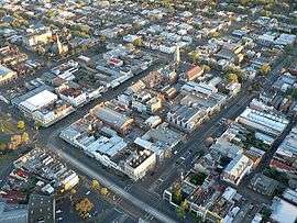 Aerial view of North Melbourne | |||||||||||||
| Population | 11,755 (2011 census)[1] | ||||||||||||
| • Density | 4,900/km2 (12,690/sq mi) | ||||||||||||
| Established | 1850s | ||||||||||||
| Postcode(s) | 3051 | ||||||||||||
| Area | 2.4 km2 (0.9 sq mi) | ||||||||||||
| Location | 2 km (1 mi) from Melbourne | ||||||||||||
| LGA(s) | City of Melbourne | ||||||||||||
| State electorate(s) | Melbourne | ||||||||||||
| Federal Division(s) | Melbourne | ||||||||||||
| |||||||||||||
North Melbourne is a suburb of Melbourne, Australia, 2 km north-west of Melbourne's Central Business District. Its local government area is the City of Melbourne. At the 2011 Census, North Melbourne had a population of 11,755.
North Melbourne is bounded by the CityLink freeway to the west, Victoria Street to the south, O'Connell and Peel Streets to the east and Flemington Road to the north. Since July 2008 its local government area has been the City of Melbourne, when it took over the administration of parts of Kensington and North Melbourne that were previously under the City of Moonee Valley, resulting in an increase of approximately 4760 residents and almost 3000 workers (2006 Census).[2]
Formerly known as Hotham, it was essentially a working class area, with some middle class pockets,[3] and was one of the first towns in Victoria to be granted Municipal status.
Today it continues to undergo gentrification, noted for its Victorian architecture, cosmopolitan demographic, commercial and older industrial areas.
History
North Melbourne's first institutions were built in the 1840s, beginning with a cattle yard. At this time the area was not well defined and included Parkville and Royal Park, as well as a part of West Melbourne.
In the 1850s a Benevolent Asylum was built between Abbotsford and Curzon Streets, coinciding with the desire to find space to accommodate the growing population from the gold rush. (The Asylum remained a feature of the area until its move to Cheltenham in 1911.[4]) In 1859 the area was named Hotham borough, after the governor of Victoria Charles Hotham. Hotham Post Office opened on 20 March 1860.
By 1861, Hotham had a population of over 7,000.
In 1869 some of these decided to form the Hotham Football Club that later became a foundation member of the VFA (Australian rules football) today known as the North Melbourne Kangaroos.
On 26 August 1887 the Borough was renamed North Melbourne Town, after the completion of the imposing North Melbourne Town Hall and the Metropolitan Meat Market.[5]
Although there were pockets of middle class housing in the wider tree-lined streets such as Dryburgh, Chapman and Brougham, by the 1880s the suburb had become a predominantly working class area with most of the male population employed in local industry.[3]
In the 1890s tram routes had entered the area as far as Abbotsford Street, walking distance from the Arden Street Oval.
In the 1930s many areas of North Melbourne, in particular the laneways, became overcrowded and defined as slums. As such, large government housing development projects were proposed, which were eventually completed in the 1960s.
Commercial centre
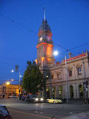
The main shopping strip of Errol Street is located around the old North Melbourne Town Hall.
Since the 1990s it has become something of an upmarket strip, home to a number of popular cafes and boutiques.
Demographics
North Melbourne's real estate is above the Melbourne median and the suburb remains an overwhelmingly middle-class community.[6] Median weekly household income was $1,229 at the 2011 census, very similar to the national median of $1,234.[1]
It does, however, have a strong migrant mix, having been a popular destination for low income families for decades. More recent arrivals are refugees from countries such as Somalia and Eritrea; they live around the government-owned housing estates near the Melrose Street area, on the suburb's fringe.[7] At the 2011 census, 40% of residents reported being born in Australia, compared to the national average of 69.8%; the next most common countries of birth were China 7.3%, Malaysia 3.3%, New Zealand 2.6%, Vietnam 2.5% and England 2.5%.[1]
Residents of North Melbourne are significantly younger than most other areas; their median age was 29 years, compared to the national median age of 37. Children aged under 15 years made up 11.1% of the population and people aged 65 years and over made up just 7.5% of the population.[1]
Religion
The most common religious affiliation in North Melbourne is "No Religion",[1] but some churches remain such as Curzon Street Church (now known as St Mark the Evangelist), St Mary's Anglican Church and the ornate Ukrainian Catholic Cathedral, built in 1963, on the high section of Dryburgh Street. The Catholic Church and Parish Primary School of St Michaels are also located in North Melbourne.
Housing
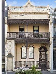
Historically, the predominant housing types were old Victorian-style terrace houses, warehouses, and some low-rise apartments. By the time of the 2011 census, this had changed and 58% of private dwellings were flats, units or apartments. 37% were semi-detached (row or terrace houses, townhouses etc.), 4.3% were separate houses, and 0.6% were classified as "other dwellings".[1]
North Melbourne was slower to gentrify than other inner suburbs, due to established families resisting the sale of their homes for decades. A younger generation finally began to move in the 1980s, capitalising on the proximity to the Melbourne City Centre. Many of the old factories and warehouses were converted into fashionable loft-style apartments in 1990s. Since 2000, there has been a large increase in new medium density apartment complexes being built and house prices now exceed Melbourne's median.
As of February 2016, the median house price was $882,500 at an annual growth of 7.25%. The median price of units was $487,500, having grown at 5.72%.[6]
Culture
"Spring Fling" is an annual festival for North and West Melbourne.
The heritage listed town hall and former Meat Market are both theatre and arts spaces.
Sport

The North Melbourne Football Club is still active and plays in the national Australian football competition, the Australian Football League. The club's football department and training sessions are based at its traditional home ground at Arden Street Oval, which has recently been redeveloped.
Transport
Major roads include Flemington Road, Elizabeth Street and Victoria Street.
The main railway station is Flemington Bridge, which is on the Upfield railway line. Despite the naming, the North Melbourne railway station is actually in the adjacent suburb of West Melbourne, while the Flemington Bridge railway station is within North Melbourne boundaries and not in Flemington. The Arden railway station is planned to be built on Arden Road within North Melbourne's industrial area as part of the Melbourne Metro Rail Project.
North Melbourne is serviced by a number of tram routes:
- Tram route 59 (Airport West): travels along Elizabeth Street and down Flemington Road.
- Tram route 57 (West Maribyrnong): travels along Victoria, Errol, Queensberry and Abbotsford Streets, then down Flemington Road.
- Tram route 55 (West Coburg): travels down Flemington Road and then into Royal Park at Abbotsford Street, just skimming the boundary of North Melbourne.
It also has a number of bus routes.
See also
- City of Moonee Valley – the local government area of which North Melbourne was a part
References
- 1 2 3 4 5 6 Australian Bureau of Statistics (31 October 2012). "North Melbourne (State Suburb)". 2011 Census QuickStats. Retrieved 7 July 2012.
- ↑ "Suburbs - City of Melbourne".
- 1 2 Murphy (Webmaster), Guy. "'Hotham History Project'". Hotham History Project Inc. Hotham History Project Inc. Retrieved 24 April 2015.
Surrounding it (the Asylum) was housing stock which varied greatly in quality, more working than middle-class
- ↑ .Kingston Historical Website, The Melbourne Benevolent Asylum Comes to Cheltenham, retrieved 15 September 2013
- ↑ .Premier Postal History, Post Office List, retrieved 11 April 2008
- 1 2 "Free Suburb Profile report for North Melbourne VIC (3051)".
- ↑ "Across the African divide". Inside Story.
External links
![]() Media related to North Melbourne, Victoria at Wikimedia Commons
Media related to North Melbourne, Victoria at Wikimedia Commons
Coordinates: 37°47′57″S 144°56′48″E / 37.79917°S 144.94667°E