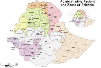
North Gondar Zone
Semien Gondar (or North Gondar) is a Zone in the Ethiopian Amhara Region. This Zone is named for the city of Gondar, the capital of Ethiopia until the mid-19th century, which has often been used as a name for the 20th century province of Begemder.
Semien Gondar is bordered on the south by Lake Tana, Mirab (West) Gojjam, Agew Awi and the Benishangul-Gumuz Region, on the west by Sudan, on the north by the Tigray Region, on the east by Wag Hemra and on the southeast by Debub Gondar. Towns and cities in Semien Gondar include Dabat, Debarq, Emfranz, Gondar, Gorgora and Metemma.
Demographics
Based on the 2007 Census conducted by the Central Statistical Agency of Ethiopia (CSA), this Zone has a total population of 2,929,628, an increase of 40.26% over the 1994 census, of whom 1,486,040 are men and 1,443,588 women; with an area of 45,944.63 square kilometers, Semien Gondar has a population density of 63.76. While 462,700 or 15.79% are urban inhabitants, a further 2,148 or 0.07% are pastoralists. A total of 654,803 households were counted in this Zone, which results in an average of 4.47 persons to a household, and 631,509 housing units. The main ethnic group reported in Semien Gondar was the Amhara (97.84%); all other ethnic groups made up 2.16% of the population. Amharic was spoken as a first language by 98.32%; the remaining 1.62% spoke all other primary languages reported. 95.38% practiced Ethiopian Orthodox Christianity, and 4.29% of the population said they were Muslim.[1]
The 1994 national census reported a total population for this Zone of 2,088,684 in 434,297 households, of whom 1,059,698 were men and 1,028,986 women; 236,625 or 11.33% of its population were urban dwellers at the time. The three largest ethnic groups reported in Semien Gondar were the Amhara (89.72%), the Qemant (8.25%), and the Tigrayan (0.94%); all other ethnic groups made up 1.09% of the population. Amharic was spoken as a first language by 98.24%, and 0.81% spoke Tigrinya; the remaining 0.95% spoke all other primary languages reported. 95.32% practiced Ethiopian Orthodox Christianity, and 4.54% of the population said they were Muslim.[2]
According to a May 24, 2004 World Bank memorandum, 7% of the inhabitants of Semien Gondar have access to electricity, this zone has a road density of 21.2 kilometers per 1000 square kilometers (compared to the national average of 30 kilometers),[3] the average rural household has 1.2 hectare of land (compared to the national average of 1.01 hectare of land and an average of 0.75 for the Ahmara Region)[4] and the equivalent of 0.8 heads of livestock. 24.6% of the population is in non-farm related jobs, compared to the national average of 25% and a Regional average of 21%. 50% of all eligible children are enrolled in primary school, and 13% in secondary schools. 62% of the zone is exposed to malaria, and none to tsetse fly. The memorandum gave this zone a drought risk rating of 506.[5]
Notes
- ↑ Census 2007 Tables: Amhara Region, Tables 2.1, 2.4, 2.5, 3.1, 3.2 and 3.4.
- ↑ 1994 Population and Housing Census of Ethiopia: Results for Amhara Region, Vol. 1, part 1, Tables 2.1, 2.7, 2.10, 2.13 2.17 (accessed 6 April 2009)
- ↑ "Ethiopia - Second Road Sector Development Program Project", p.3 (World Bank Project Appraisal Document, published 19 May 2003)
- ↑ Comparative national and regional figures comes from the World Bank publication, Klaus Deininger et al. "Tenure Security and Land Related Investment", WP-2991 (accessed 23 March 2006).
- ↑ World Bank, Four Ethiopias: A Regional Characterization (accessed 23 March 2006).
Coordinates: 12°45′N 37°00′E / 12.750°N 37.000°E
Zones of the Amhara Region | ||
|---|---|---|
| Current zones | ||
| Special woredas | ||
Woredas of the Semien Gondar Zone | ||
|---|---|---|
| Former woredas | ||
| Current woredas | ||