Farallon Islands
| Farallon National Wildlife Refuge | |
|---|---|
|
IUCN category IV (habitat/species management area) | |
|
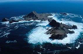
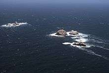
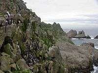
Southeast Farallon Islands from the west, with Maintop Island in the foreground (right) | |
 | |
| Location | Pacific Ocean |
| Nearest city | San Francisco, California, United States |
| Coordinates | 37°43′30″N 123°01′49″W / 37.7249303°N 123.0302779°WCoordinates: 37°43′30″N 123°01′49″W / 37.7249303°N 123.0302779°W |
| Area | 41.9 hectares (104 acres) |
| Established | 1969 |
| Governing body | United States Fish and Wildlife Service |
| Website | Farallon National Wildlife Refuge |
|
Farallone Islands | |
| Area | 211 acres (85.4 ha) |
| Built | 1539 |
| NRHP Reference # | 77000332[1] |
| Added to NRHP | March 08, 1977 |

The Farallon Islands, or Farallones (from the Spanish farallón meaning "pillar" or "sea cliff"), are a group of islands and sea stacks in the Gulf of the Farallones, off the coast of San Francisco, California, United States. They lie 30 miles (48 km) outside the Golden Gate and 20 miles (32 km) south of Point Reyes, and are visible from the mainland on clear days. The islands are officially part of the City and County of San Francisco. The only inhabited portion of the islands is on Southeast Farallon Island (SEFI), where researchers from Point Blue Conservation Science and the U.S. Fish and Wildlife Service stay.[2] The islands are closed to the public.[3]
The Farallon National Wildlife Refuge is one of 63 National Wildlife Refuges that have congressionally designated wilderness status.[4] In 1974 the Farallon Wilderness was established (Public Law 93-550) and includes all islands except the Southeast Island for a total of 141 acres (57 ha).[5]
History

The islands were long known by the name "Islands of the Dead" to the American Indians who lived in the Bay Area prior to the arrival of Europeans, but they are not thought to have traveled to them, either for practical reasons (the voyage and landing would be difficult and dangerous) or because of superstition (the islands were believed to be an abode of the spirits of the dead).[6][7][8]
The first European to land and record the islands was Spanish explorer Juan Rodriguez Cabrillo in 1539, who named the islands "Farallones", Spanish for cliffs or small pointed islets.[9] Cabrillo had departed from Puerto de Navidad in México with two ships (three according to others): San Salvador, Victoria, and San Miguel, after which Catalina Island, Clemente and San Diego Bay were respectively named in this voyage. The expedition missed the entrance to San Francisco Bay, but it sighted and named nearby places such as "Punta de los Pinos" (Point Reyes), and "Bahia de los Pinos" (Monterey Bay).[10]
On July 24, 1579, English privateer and explorer Sir Francis Drake landed on the islands, in order to collect seal meat and bird eggs for his ship.[9] He named them the Islands of Saint James because the day after his arrival was the feast day of St James the Great. The name of St James is now applied to only one of the rocky islets of the North Farallones.
The islands were given the name "Los Frayles" ("The Friars") by Spanish explorer Sebastián Vizcaíno, when he first charted them in 1603.
In the years following their discovery, during the Maritime Fur Trade era, the islands were exploited by seal hunters, first from New England and later from Russia. The Russians maintained a sealing station in the Farallones from 1812 to 1840, taking 1,200 to 1,500 fur seals annually, though American ships had already exploited the islands.[11] The Albatross, captained by Nathan Winship, and the O'Cain, captained by his brother Jonathan Winship, were the first American ships sent from Boston in 1809 to establish a settlement on the Columbia River. In 1810, they met up with two other American ships at the Farallon Islands, the Mercury and the Isabella, and at least 30,000 seal skins were taken.[12][13] By 1818 the seals diminished rapidly until only about 500 could be taken annually and within the next few years, the fur seal was extirpated from the islands. It is not known whether the northern fur seal or the Guadalupe fur seal were the islands' native fur seal, although the northern fur seal is the species that began to recolonize the islands in 1996.[14]
On July 17, 1827, the French sea captain Auguste Duhaut-Cilly sailed by the southernmost Farallon Island and counted the "crude dwellings of about a hundred Kodiaks stationed there by the Russians of Bodega...the Kodiaks, in their light boats, slip into San Francisco Bay by night, moving along the coast opposite the fort, and once inside this great basin they station themselves temporarily on some of the inner islands, from where they catch the sea otter without hindrance."[15]
After Alta California was ceded by Mexico to the United States in 1848 with the Treaty of Guadalupe Hidalgo, the islands' environment became linked to the growth of the city of San Francisco. Beginning in 1853, a lighthouse was constructed on SEFI. As the city grew, the seabird colonies came under severe threat as eggs were collected in the millions for San Francisco markets. The trade, which in its heyday could yield 500,000 eggs a month, was the source of conflict between the egg collecting companies and the lighthouse keepers. This conflict turned violent in a confrontation between rival companies in 1863. The clash between two rival companies, known as the Egg War, left two men dead and marked the end of private companies on the islands, although the lighthouse keepers continued egging. This activity, combined with the threat of oil spills from San Francisco's shipping lanes, prompted President Theodore Roosevelt to sign Executive Order No. 1043 in 1909, creating the Farallon Reservation to protect the chain's northern islands. This was expanded to the other islands in 1969 when it became a National Wildlife Refuge.
The islands are the site of many shipwrecks. The liberty ship SS Henry Bergh, a converted troop carrier that hit West End in 1944, pieces of which can still be seen from the island today (all hands were saved). The USS Conestoga, a US Navy tugboat that disappeared with its 56 crew members in 1921, was found in 2009 and positively identified in 2016. (The Conestoga had sailed from nearby San Francisco, but the waters of the Farallons were never searched because the vessel was assumed to have traveled far out into the Pacific.)[16]
The islands have also been mentioned in connection with the schooner Malahat as one possible site for Rum Row during Prohibition.[17] The United States Coast Guard maintained a manned lighthouse until 1972, when it was automated. The islands are currently managed by the United States Fish and Wildlife Service, in conjunction with the Marin-based Point Blue Conservation Science (formerly Point Reyes Bird Observatory - PRBO). The islands are currently the subject of long term ecological research. Today, the Farallones are closed to the public, although birders and wildlife enthusiasts can approach them on whale watching boats and the sail-training vessel Seaward out of Sausalito.[18]
From 1902 to 1913, the former U.S. Weather Bureau maintained a weather station on the southeast island, which was connected with the mainland by cable. The results of the meteorological study were later published in a book on California's climate. Temperatures during those years never exceeded 90 °F (32 °C) or dropped to 32 °F (0 °C).[19] Years later, the National Weather Service provided some weather observations from the lighthouse on its local radio station.
Three people have successfully swum from the Farallones to the Golden Gate, with two more swimming to points north of the Gate. The first, Ted Erikson, made the swim in September 1967, with the second, Joseph Locke, swimming to the Golden Gate on July 12, 2014, in 14 hours.[20] The third person, and the first woman to complete the distance, Kimberley Chambers, made it in just over 17 hours on Friday August 7, 2015.[21]
Geology
The Farallon Islands are outcroppings of the Salinian Block, a vast geologic province of granitic continental crust sharing its origins with the core of the Sierra Nevada Mountains. The block was torn off far to the south of its present position and rifted north by the movement of the Pacific Plate on which the islands rest. Other nearby examples of the Salinian Block include the Point Reyes Peninsula and Bodega Head. The San Andreas Fault, marking a boundary zone between the Pacific and North American Plates, passes a few miles east of the islands.
The ancient Farallon Plate is named after the islands.
Geography

Overview
The islands string northwestward from Southeast Farallon Island for 5 miles (8.0 km). Their total land area is 0.16 square miles (0.41 km2). The islands were initially exploited for bird eggs and fur seal skins, then used as a lighthouse station and a radio station. They have been protected in the Farallon National Wildlife Refuge, first established in 1909 with the Southeast Farallons added in 1969,[22] and contain the largest seabird colony in the U.S. outside of Alaska and Hawaii. The islands are part of the City and County of San Francisco, and are considered part of Supervisorial District One (Northwest), also called Richmond District.
| Block Nr.[note 1] |
Island(s) or Bank | Area (m2) |
Height (m) |
Coordinates |
|---|---|---|---|---|
| 2000 | South Farallon Islands | 387,688 | 109 | 37°41′49″N 123°00′07″W / 37.69694°N 123.00194°W |
| 2001 | Middle Farallon Island | 3,362 | 6 | 37°43′37″N 123°01′52″W / 37.72694°N 123.03111°W |
| 2002 | North Farallon Islands | 28,270 | 47 | 37°45′37″N 123°05′49″W / 37.76028°N 123.09694°W |
| - | Fanny Shoal | - | -4 | 37°46′40″N 123°10′19″W / 37.77778°N 123.17194°W |
| 2999[note 2] | Farallon Islands | 419,320 | 109 | |
- ↑ of Block group 2, Census tract 604, San Francisco County, California[23]
- ↑ Block Number of Territorial Waters, with an area of 247,530,823 m2
South Farallon Islands

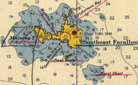
- Southeast Farallon Island (SEFI) is the largest island, with an area of 95.79 acres or 0.14970 square miles (0.3877 km2), and is the only inhabited one. The island is pyramidal in shape and 357 feet (109 m) high. The peak, Tower Hill (actually a double peak consisting of Lighthouse Hill and Little Lighthouse Hill), is the location of a lighthouse, the Farallon Island Light. The large flat area in the southeast of the island is called Marine Terrace. Immediately south of it is Mussel Flat, about 100 feet (30 m) by 400 feet (120 m), which is cut off from the main island only during high tide.
- Seal Rock (Saddle Rock), about 800 feet (240 m) south of SEFI, is about 350 feet (110 m) by 800 feet (240 m) in size and 80 feet (24 m) high.
- Maintop Island (West End) is immediately to the west of SEFI, separated by a narrow impassable gorge, The Jordan (Jordan Channel), which connects Mirounga Bay in the south to Maintop Bay in the north. It is the second largest island, and 220 feet (67 m) high at Main Top hill in its eastern part. The Great West Arch, a rock formation, is in the west of the island, and Indian Head in the south.
- The Drunk Uncle Islets are a group of small rocks just northwest off Maintop Island.
- Aulone Island and smaller Great Arch Rock (Arch Rock) are immediately north of the northern tip of SEFI, and together about 200 feet (61 m) by 350 feet (110 m) in size. They are barely separated by a narrow gorge. Great Arch Rock is not to be confused with Great West Arch, a rock formation in the west of Maintop Island.
- Sugarloaf Island (usually just referred to as Sugarloaf) is northeast of Great Arch Rock, and just slightly larger in size, with a height of 80 feet (24 m). Southwest of Aulon Island, Great Arch Rock and Sugarloaf Island, and in the northeast of SEFI, is protected Fisherman Bay.
- Sea Lion Rock is just northwest of Aulon Island, diameter approximately 130 feet (40 m).
- Hurst Shoal is located about one kilometer southeast of the southeastern corner of SEFI. It has a least depth of 20 feet (6.1 m).
Middle Farallon Island
Middle Farallon Island, 2 miles (3.2 km) northwest of SEFI, is a 20-foot (6.1 m) high guano-covered black rock about 65 meters in diameter, with an area of 3,362 m2. This island is informally known as "the pimple."
North Farallon Islands
North Farallon Islands, about 7 km further northwest, consist of two clusters of bare precipitous islets and rocks 31 to 85 meters high, with an aggregate area of 28,270 m2
- North Farallon Island, 31 meters high, about 150 meters long north-south, 9,260 m2
- Island of St. James, 47 meters high, about 125 meters in diameter, 12,380 m2
- unnamed rock, about 85 meters in diameter, and 5,640 m2 in area
- four smaller unnamed rocks, diameter 20 meters and less
Some of those unnamed rocks however have Spanish names, such as Piedra Guadalupe, Peñasco Quebrado and Farallón Vizcaíno.
Fanny Shoal
5 km WNW of the North Farallones is Fanny Shoal, a bank 3 km in extent, with depth less than 55 meters, marking the northernmost and westernmost feature of the group, albeit entirely submerged. Noonday Rock, which rises abruptly from a depth of 37 meters, with a least depth of 4 meters (13 ft) over it at low tide, is the shallowest point of Fanny Shoal. There is a lighted bell buoy about 1 km west of Noonday Rock. Noonday Rock derives its name from that of the clipper ship that struck it on January 1, 1863 and sank within one hour.[24]
Banks northwest of Fanny Shoal
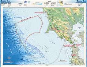
The banks northwest of Fanny Shoal are not considered part of the Farallon Islands anymore, and they are outside of U.S. territorial waters. About 25 km northwest of Fanny Shoal is Cordell Bank, a significant marine habitat (38°01′N 123°25′W / 38.017°N 123.417°W). About halfway between Fanny Shoal and Cordell Bank is Rittenburg Bank, with depths of less than 80 meters (37°53′N 123°18′W / 37.883°N 123.300°W).
Fauna and flora
Seabirds
The Farallon Islands are an important reserve protecting a huge seabird colony. The islands' position in the highly productive California Current and eastern Pacific upwelling region, as well as the absence of other large islands that would provide suitable nesting grounds, result in a seabird population of over 250,000. Twelve species of seabird and shorebird nest on the islands; western gull, Brandt's cormorant, pelagic cormorant, double-crested cormorant, pigeon guillemot, common murre, Cassin's auklet, tufted puffin, black oystercatcher, rhinoceros auklet, ashy storm-petrel, and Leach's storm-petrel. Since the islands were protected, common murres, which once numbered nearly 500,000 pairs but suffered from the egg collecting, oil spills and other disturbances that had greatly reduced their numbers, recovered and climbed from 6,000 birds to 160,000. Additionally, since protection, the locally extinct rhinoceros auklet has begun to breed on the islands again. The island has the world's largest colonies of western gulls and ashy storm petrels, the latter species being considered endangered and a conservation priority. The island also is the wintering ground of several species of migrants, and regularly attracts vagrant birds (about 400 species of bird have been recorded on or around the island).
Seals
Five species of pinniped come to shore on the islands, and in some cases breed. These are the northern elephant seal, harbor seal, Steller's sea lion, California sea lion, and the northern fur seal (the last of which, like the rhinoceros auklet, began to return to the island again after protection).
American whalers took 150,000 northern fur seals (Callorhinus ursinus) from the Farallons between 1810 and 1813, followed by Russian fur hunters who lived on the Farallons and extirpated the pinnipeds from the islands. In 1996 West End Island became the fourth American northern fur seal rookery when a pup was born. The recolonizers bore tags from San Miguel Island in the Channel Islands. By 2006, nearly 100 pups were born.[25] The fur seals are aggressive and have displaced larger sea lions from their territory. The high count for 2011 was 476 individuals, a 69 percent increase from the year before.[26]
Whales
Several species of cetaceans are found near the Farallon Islands, most frequently gray whales, blue whales, and humpback whales. Blue whales and humpback whales are most frequently found near the islands in the summer and fall, when strong upwelling may support a rich pelagic food web. Killer whales are also found around the islands. Gray whales are reliably found near the Farallones during their spring migration north and the fall/winter migration south. Some gray whales may also be found during the summer, when a few whales skip the trip north to Alaska and spend the summer months off the coast of Canada and the continental United States.
In December 2005 one humpback was rescued from netting entanglement east of the Farallones by staff of The Marine Mammal Center.[27] The last sighting of another famous humpback, named Humphrey, was near the Farallones in 1991. The islands are in the Gulf of the Farallones National Marine Sanctuary, which protects the feeding grounds of the wildlife of the refuge.
Sharks
The elephant seal population attracts a population of great white sharks to the islands. In 1970 Farallon biologists witnessed their first shark attack, on a Steller’s sea lion. During the next fifteen years, more than one hundred attacks on seals and sea lions were observed at close range. By the year 2000, biologists were logging almost eighty attacks in a single season.[28]
While the males return annually, the females return only every other year, often with fresh, deep bites around their heads. The seasonal shark population at the Farallones is unclear, with estimates from thirty to one hundred. The Farallones are unique in the size of the great whites that are attracted. The average length of a full-grown great white shark is 4 to 4.8 metres (13.3 to 15.8 ft), with a weight of 680 to 1,100 kilograms (1,500 to 2,450 lbs), females generally being larger than males. Farallon great whites range between the "smaller" males at 13 ft (4.0 m) to the females, which generally range between 17 ft (5.2 m) to 19 ft (5.8 m). The largest accurately measured great white shark was a female caught in August 1988 at Prince Edward Island off the North Atlantic coast and measured 20.3 ft (6.2 m). A killer whale was recorded killing a great white near the Farallones in 1997.[29] Over the decades of study, many of the individual white sharks visiting the Farallones have been nicknamed, often based off their scars and appearances, such as Gouge, The Hunchback, The Jester, and Stumpy. Stumpy, an 18-foot female great white, in particular was well known for her appearance in the BBC documentary "Great White Shark" narrated by David Attenborough and stock footage of her attacks on decoys is often utilized in more recent documentaries, and another example, Tom Johnson, a 16-foot male white shark that was featured in an episode of the 2012 season of Shark Week called "Great White Highway" is believed to be the oldest living white shark so far documented returning to the Farallones, estimated at around 25–30 years old.[30]
Some individual sharks have been tagged and found to roam the Pacific as far as Hawaii and Guadalupe Island off Baja California, returning regularly to the Farallones every year in the autumn. Satellite tracking has revealed the majority of great white sharks from the Faralllones (and from other parts of California, Hawaii and the west coast of Mexico) migrate to an area of ocean dubbed the White Shark Café, 1,500 miles (2,400 km) west of Ensenada, Baja California. The peak of activity at this location is from mid-April to Mid-July, but some shark spend up to eight months of the year there.[31]
Rodents
According to a report in USA Today, it is the most rodent-dense island in the world, with an average of 500 Eurasian house mice occupying each of its 120 acres (49 ha) and an amount of 60,000 total.[32]
Nuclear waste dump
From 1946 to 1970, the sea around the Farallones was used as a nuclear dumping site for radioactive waste under the authority of the Atomic Energy Commission at a site known as the Farallon Island Nuclear Waste Dump. Most of the dumping took place before 1960, and all dumping of radioactive wastes by the United States was terminated in 1970. By then, 47,500 containers (55-gallon steel drums) had been dumped in the vicinity, with a total estimated radioactive activity of 14,500 Ci. The materials dumped were mostly laboratory materials containing traces of contamination. Much of the radioactivity had decayed by 1980.[33]
44,000 containers were dumped at 37°37′N 123°17′W / 37.617°N 123.283°W, and another 3,500 at 37°38′N 123°08′W / 37.633°N 123.133°W.[33]
The exact location of the containers and the potential hazard the containers pose to the environment are unknown.[34] Attempts to remove the barrels would likely produce greater risk than leaving them undisturbed.[33]
Waste containers were shipped to Hunters Point Shipyard, then loaded onto barges for transportation to the Farallones. Containers were weighted with concrete. Those that floated were sometimes shot with rifles to sink them.[35]
In January 1951, the highly radioactive hull of USS Independence, which was used in Operation Crossroads and then loaded with barrels of radioactive waste, was scuttled in the area.[36]
See also
- Case of the Channel Islands of California (History).
References
- ↑ National Park Service (2009-03-13). "National Register Information System". National Register of Historic Places. National Park Service.
- ↑ "Point Blue | Conservation Science, PRBO". Prbo.org. Retrieved 2015-06-05.
- ↑ "Farallon National Wildlife Refuge". Fws.gov. Retrieved 2015-06-05.
- ↑ "Learn About Wilderness National Wildlife Refuge System" (pdf). United States Fish and Wildlife Service. August 2013. Retrieved 8 June 2015.
- ↑ "Federal Register" (PDF). Edocket.access.gpo.gov. May 31, 2005. p. 2. Retrieved 2015-06-05.
- ↑ Danny Sedevic. "A History of the Farallon Islands". Farallones Marine Sanctuary Association. Retrieved February 8, 2015.
- ↑ "Farallon Islands - Gulf of the Farallones". SF Bay Adventures. Retrieved February 8, 2015.
- ↑ Sam McManis (June 16, 2013). "California islands: The bird paradise of the Farallons". The Sacramento Bee. Retrieved February 8, 2015.
- 1 2 "Farallones, Farallone Islands, Los Farallones, Farallon Islands National Register of Historic Places Inventory – Nomination Form" (PDF). United States National Park Service, National Park Service. 7 March 1977.
- ↑ Wagner, Henry (2007). Juan Rodriguez Cabrillo, Discoverer of the Coast of California.
- ↑ Thompson, R. A. (1896). The Russian Settlement in California Known as Fort Ross, Founded 1812...Abandoned 1841: Why They Came and Why They Left. Santa Rosa, California: Sonoma Democrat Publishing Company. p. 7. ISBN 0-559-89342-6.
- ↑ Hubert Howe Bancroft (1886). Albatross, Log-book of a Voyage to the Northwest Coast in the Years 1809-1812, Kept by Wm. Gale, MS in History of California: 1801-1824. A.L. Bancroft & Company. pp. 93–94. Retrieved Apr 9, 2010.
- ↑ Freeman Hunt (1846). "First Trading Settlement on the Columbia River". Merchants' Marine and Commercial Review. New York. 14: 202. Retrieved Apr 9, 2010.
- ↑ White 1995.
- ↑ Auguste Duhaut-Cilly (1997). August Fruge, Neal Harlow, eds. A Voyage to California, the Sandwich Islands, and Around the World in the Years 1826-1829. Berkeley and Los Angeles, California: University of California Press. p. 123. ISBN 978-0-520-21752-2. Retrieved 2011-09-20.
- ↑ Philipps, Dave (25 March 2016). "Discovery of Navy Shipwreck Solves 95-Year-Old Mystery". The New York Times. Retrieved 25 March 2016.
- ↑ Vancouver Maritime Museum (2011). "Malahat". Vancouver Maritime Museum. Retrieved Mar 24, 2011.
- ↑ "Home". Callofthesea.org. Retrieved 2015-06-05.
- ↑ U.S. Fish & Wildlife Service
- ↑ John Coté (2014-07-13). "Swimmer reaches Golden Gate from Farallones". San Francisco Chronicle. Retrieved 2015-06-05.
- ↑ "San Francisco". NBC Bay Area.
- ↑ "Farallon Wilderness - General Information". Wilderness.net. Retrieved 2015-06-05.
- ↑ https://web.archive.org/web/20070102064455/http://factfinder.census.gov:80/servlet/DTTable?_bm=y. Archived from the original on January 2, 2007. Retrieved January 21, 2007. Missing or empty
|title=(help) - ↑ Channel Islands National Marine Sanctuary. "Shipwreck Database: Vessel Noonday". National Oceanic and Atmospheric Administration (NOAA). Retrieved 2009-08-25.
- ↑ Aleta George (2007-04-01). "Farallon Island Fur Seals". Bay Nature. Retrieved 2012-12-19.
- ↑ Juliet Grable (2011-10-05). "Fur Seals Making a Comeback on the Farallones". Bay Nature. Retrieved 2012-12-19.
- ↑ Fimrite, Peter (December 14, 2005). "Daring rescue of whale off Farallones". San Francisco Chronicle.
- ↑ Casey 2005, Introduction.
- ↑ "The Whale That Ate Jaws". Channel.nationalgeographic.com. Retrieved 2010-11-22.
- ↑ Casey 2005.
- ↑ Casey 2005, pp. 93–94.
- ↑ Seamons, Kate (2013-08-19). "World's most rodent-packed island has just 2 options". USA Today. Gannett Company. Retrieved 2014-06-22.
- 1 2 3 Office of Radiation Programs (14 August 1980). "Radioactive Waste Dumping Off the Coast of California, Fact Sheet" (PDF). U.S. Environmental Protection Agency: 2, 6. Retrieved 2009-08-24.
- ↑ U.S. Geological Survey (22 July 2009). "Farallon Island Radioactive Waste Dump". U.S. Department of the Interior. Retrieved 2009-08-25.
- ↑ "Scientists find radioactive WWII aircraft carrier off San Francisco coast". San Jose Mercury News. April 16, 2015. Retrieved 2015-12-08.
Sources
- Casey, Susan (7 June 2005). The Devil's Teeth: A True Story of Obsession and Survival Among America's Great White Sharks. Henry Holt and Company. ISBN 978-0-8050-7581-6. WP article
- White, Peter (1995). The Farallon Islands: Sentinels of the Golden Gate. San Francisco, California: Scottwall Associates. ISBN 0-942087-10-0.
- Ainley, David G. (1990). Seabirds of the Farallon Islands: Ecology, Dynamics, and Structure of an Upwelling-system Community. Stanford University Press. ISBN 978-0-8047-1530-0.
External links
| Wikimedia Commons has media related to Farallon Islands. |
- Farallon National Wildlife Refuge USFWS
- Satellite map and NOAA Chart of Farallon Islands on BlooSee
- Farallon Islands San Francisco Chronicle
- Farallon Islands at the Center for Land use Interpretation
- Article about nuclear waste at the Farallons
- farallones.org
- Area figures from Bureau of the Census
- The Farallon Blog Weblog of the field biologists on the Farallon Islands
- Aerial photography of the Farallones
- Live streaming video from the South East Farallon Island California Academy of Sciences
- Farallon Islands Foundation a SF Bay Area non-profit wildlife conservation group
| Topics | |
|---|---|
| Lists by states |
|
| Lists by insular areas | |
| Lists by associated states | |
| Other areas | |
| |