North Carolina Highway 92
| ||||
|---|---|---|---|---|
 | ||||
| Route information | ||||
| Maintained by NCDOT | ||||
| Length: | 20.70 mi[1] (33.31 km) | |||
| Major junctions | ||||
| West end: |
| |||
|
| ||||
| East end: |
| |||
| Location | ||||
| Counties: | Beaufort | |||
| Highway system | ||||
| ||||

North Carolina Highway 92 (NC 92) is a North Carolina state highway that runs through Beaufort County connecting Washington and Bath.
Route description
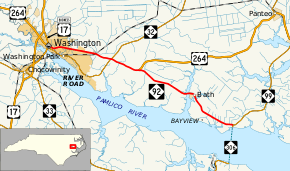
NC 92 begins at the intersection of North Bridge Street and West 5th Street in downtown Washington, the county seat of Beaufort County. North Bridge Street carries U.S. Route 17 Business (US 17 Bus.) north and south while West 5th Street carries US 264 east and west. NC 92 and US 264 run along a concurrency from this point and travel east-southeast through a mix of businesses, houses, and open space. After one-half mile (0.80 km) the road curves to the north and the road name changes to John Small Avenue. Since the beginning of the road, the width was one lane in each direction with a center turn lane. About one mile (1.6 km) from the start, the roadway widens to two lanes in each direction with a center turn lane and it passes some schools and more businesses and houses. As it exits the city limits, US 264 and NC 92 begin to head into a more sparsely populated area of the county, crossing a railroad at-grade and passing Beaufort County Community College. At Douglas Crossroads, NC 32 intersects the highway. Past this intersection, the highway narrows to two lanes in each direction. Three miles (4.8 km) past NC 32 at the community of Midway, US 264 bends towards the north while NC 92 breaks off the concurrency and heads on a two-lane road east towards Bath.[1]
After crossing the Bath Creek on a 1,000-foot-long (300 m) bridge, the road enters the town limits of Bath. In Bath, NC 92 carries the name Carteret Street through the town and its historic district. The road bends to the southeast and intersects Bayview Avenue which provides access to the census-designated place of the same name. For the road's last three miles (4.8 km), it is bounded on the north by farmland and on the south by a thick patch of forest staying no more than one-half mile (0.80 km) north of the Pamlico River. At the community of Gaylord, NC 92 ends at the intersection of NC 99 and NC 306. This point marks the southern terminus of NC 99 which continues northeast towards Belhaven and the northern terminus of NC 306, only one-quarter mile (0.40 km) north of the North Carolina Department of Transportation Ferry Division's Bayview-Aurora Ferry.[1]
Major intersections
The entire route is in Beaufort County.
| Location | mi[1] | km | Destinations | Notes | |
|---|---|---|---|---|---|
| Washington | 0.0 | 0.0 | Western terminus of US 264/NC 92 overlap | ||
| Douglas Crossroads | 6.4 | 10.3 | |||
| Midway | 9.2 | 14.8 | Eastern terminus of US 264/NC 92 overlap | ||
| Gaylord | 20.7 | 33.3 | Southern terminus of NC 92, northern terminus of NC 306 | ||
| 1.000 mi = 1.609 km; 1.000 km = 0.621 mi | |||||
See also
- North Carolina Bicycle Route 2 - Concurrent with NC 92 from Harvey Road near Midway to its eastern terminus
References
- 1 2 3 4 Overview Map North Carolina Route 92 (Map). Google Maps. Retrieved 2009-01-21.
External links
 Media related to North Carolina Highway 92 at Wikimedia Commons
- NCRoads.com: N.C. 92