Woodstock, Alabama
| Town of Woodstock [1] | |
|---|---|
| Town | |
|
Business at the commercial center of Woodstock | |
 Location in Bibb County and the state of Alabama | |
| Coordinates: 33°07′52″N 87°05′08″W / 33.1310°N 87.0856°WCoordinates: 33°07′52″N 87°05′08″W / 33.1310°N 87.0856°W | |
| Country | United States |
| State | Alabama |
| County | Bibb |
| Area | |
| • Total | 7.2 sq mi (18.7 km2) |
| • Land | 7.1 sq mi (18.3 km2) |
| • Water | 0.2 sq mi (0.4 km2) |
| Elevation | 571 ft (174 m) |
| Population (2010) | |
| • Total | 1,428 |
| • Density | 202/sq mi (77.9/km2) |
| Time zone | Central (CST) (UTC-6) |
| • Summer (DST) | CDT (UTC-5) |
| ZIP code | 35188 |
| Area code(s) | 205 |
| FIPS code | 01-83640 |
| GNIS feature ID | 2406913[2] |
| Website |
www |

Woodstock is a town in Bibb and Tuscaloosa counties in the U.S. state of Alabama. Formerly known as North Bibb, by referendum in August 2000, the town adopted the name of a long-established local unincorporated community and as of October 1, 2000, is now known officially as "Woodstock". As of the 2010 census, the population of the town was 1,428.[3]
The Bibb County portion of Woodstock is part of the Birmingham metropolitan area, while the Tuscaloosa County portion is part of the Tuscaloosa metropolitan area.
History
Bibb County, founded as Cahawba County in 1818, played an important role in the early industrial history of Alabama. Ironworks and foundries produced goods from the brown iron ore found on Roupes Creek. Woodstock, known as North Bibb until 2000, is a small town on the northern boundary of Bibb County. This tranquil little community on Alabama 5 was once the center of a thriving railroad business.
Woodstock was first settled in the 1820s, with a formal land grant to William Houston on February 27, 1826. The settlement was established along the old Tuscaloosa to Huntsville stagecoach line. Woodstock got its name when Dr. J. U. Ray named it after the home of his ancestors, Woodstock, England. Dr. Ray's ancestors arrived in America from England at Jamestown, Virginia. In 1870, Dr. Ray built the first depot for the newly constructed Alabama-Chattanooga Railroad. After the Alabama Great Southern Railroad came the Louisville and Nashville Railroad. Each operated a depot in the area. In 1872, a line was installed down to West Blocton to ship the large abundance of coal found in the area. Woodstock became a break and storage yard for coal, red and brown iron ore and cotton. After the Civil War, rich iron ore deposits were mined. In 1872, Mr. Giles Edwards relocated to Woodstock from Tannehill and built a blast furnace to manufacture pig iron.
Mr. Edwards was later joined in the business by his son-in-law, James W. McQueen, who went on to become the president of Sloss-Sheffield Iron Company in Birmingham. In addition to the iron ore mining, coal mining, and farming, a jug factory was built to take advantage of the large deposits of fire clay that was in the area. The clay was used to make bricks, jugs, pots, and churns. As many as eight trains per day stopped in Woodstock, carrying away its riches, six of them carrying mail. Woodstock was also the roots of a newspaper business in the 1800s. This publication moved to Six Mile and then to Birmingham where it became The Birmingham News. Woodstock was incorporated in 1996 as the Town of North Bibb, with Carl Jones as mayor. Woodstock changed its name back to Woodstock by Ordinance 2008-08-03, effective October 1, 2000, S. B. Albert Hutchens, Mayor.
Geography
Woodstock is located in northern Bibb County at 33°12′4″N 87°9′1″W / 33.20111°N 87.15028°W (33.201248, -87.150242).[4] A portion of the town extends to the northwest into Tuscaloosa County. U.S. Route 11 passes northwest of the town center, leading northeast 31 miles (50 km) to downtown Birmingham and west 26 miles (42 km) to Tuscaloosa. Interstate 59 passes northwest of Woodstock, with the closest access via Exit 97 north of town.
According to the U.S. Census Bureau, the town has a total area of 7.2 square miles (18.7 km2), of which 7.1 square miles (18.3 km2) is land and 0.15 square miles (0.4 km2), or 2.11%, is water.[3]
Demographics
| Historical population | |||
|---|---|---|---|
| Census | Pop. | %± | |
| 2000 | 986 | — | |
| 2010 | 1,428 | 44.8% | |
| Est. 2015 | 1,547 | [5] | 8.3% |
| U.S. Decennial Census[6] 2013 Estimate[7] | |||
As of the census[8] of 2010, there were 1,428 people, 507 households, and 395 families residing in the town. The population density was 202 people per square mile (77.9/km²). There were 549 housing units at an average density of 76.3 per square mile (29.4/km²). The racial makeup of the town was 94.3% White, 3.4% Black, and 1.0% from two or more races. 2.1% of the population were Hispanic or Latino of any race.
There were 507 households out of which 34.3% had children under the age of 18 living with them, 61.9% were married couples living together, 10.3% had a female householder with no husband present, and 22.1% were non-families. 16.8% of all households were made up of individuals and 5.5% had someone living alone who was 65 years of age or older. The average household size was 2.79 and the average family size was 3.13.
In the town the population was spread out with 26.9% under the age of 18, 8.3% from 18 to 24, 29.3% from 25 to 44, 25.4% from 45 to 64, and 10.1% who were 65 years of age or older. The median age was 35.7 years. For every 100 females there were 100.6 males. For every 100 females age 18 and over, there were 100.4 males.
The median income for a household in the town was $48,750, and the median income for a family was $52,417. Males had a median income of $42,500 versus $32,885 for females. The per capita income for the town was $20,855. About 8.0% of families and 9.2% of the population were below the poverty line, including 8.7% of those under age 18 and 5.9% of those age 65 or over.
Notable person
- Ross F. Gray, United States Marine who posthumously received the Medal of Honor. Born in the nearby community of Marvel Valley, but buried in Woodstock.
References
- ↑ Code of Alabama 1975, Title 11, Chapter 40, Section 11-40-1
- ↑ "Woodstock". Geographic Names Information System. United States Geological Survey.
- 1 2 "Geographic Identifiers: 2010 Demographic Profile Data (G001): Woodstock town, Alabama". U.S. Census Bureau, American Factfinder. Retrieved September 16, 2013.
- ↑ "US Gazetteer files: 2010, 2000, and 1990". United States Census Bureau. 2011-02-12. Retrieved 2011-04-23.
- ↑ "Annual Estimates of the Resident Population for Incorporated Places: April 1, 2010 to July 1, 2015". Retrieved July 2, 2016.
- ↑ "U.S. Decennial Census". Census.gov. Retrieved June 6, 2013.
- ↑ "Annual Estimates of the Resident Population: April 1, 2010 to July 1, 2013". Retrieved June 3, 2014.
- ↑ "American FactFinder". United States Census Bureau. Retrieved 2015-07-08.
External links
Municipalities and communities of Bibb County, Alabama, United States | ||
|---|---|---|
| Cities | 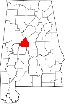 | |
| Towns | ||
| Unincorporated communities | ||
| Ghost town | ||
| Footnotes | ‡This populated place also has portions in an adjacent county or counties | |
Municipalities and communities of Tuscaloosa County, Alabama, United States | ||
|---|---|---|
| Cities | 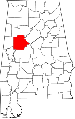 | |
| Towns | ||
| CDP | ||
| Unincorporated communities | ||
| Ghost town | ||
| Footnotes | ‡This populated place also has portions in an adjacent county or counties | |