Norristown High Speed Line
| Norristown High Speed Line | |
|---|---|
.svg.png) | |
|
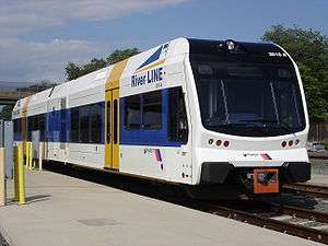
SEPTA N-5 car #144 of the Norristown High Speed Line, Route 100, as it enters the Gulph Mills Station in Upper Merion, Pennsylvania. | |
| Overview | |
| Type | Interurban/Light rapid transit |
| System | SEPTA Suburban Division |
| Status | Operational |
| Locale | Delaware and Montgomery Counties, Pennsylvania |
| Termini |
69th Street Transportation Center (south) Norristown Transportation Center (north) |
| Stations | 22 |
| Services |
|
| Daily ridership | 10,050 (average weekday FY 2014)[1] |
| Ridership | 2,419,500 (FY 2013)[2] |
| Website | Norristown High Speed Line |
| Operation | |
| Opened | 1907 |
| Operator(s) | SEPTA |
| Character | Surface (grade separated) |
| Rolling stock | 26[2] ASEA (Asea Brown Boveri) Type N-5 MU |
| Technical | |
| Line length | 13.4 mi (21.6 km)[3] |
| Number of tracks | 1–3 |
| Track gauge | 4 ft 8 1⁄2 in (1,435 mm) |
| Electrification | Third rail |
| Operating speed | 70 mph (110 km/h) |
| Route number | 100 (former) |

The Norristown High Speed Line (NHSL) is a 13.4 miles (21.6 km)[3] interurban rapid transit line, operated by SEPTA, running between Upper Darby and Norristown, Pennsylvania, United States. The rail line runs entirely on its own right-of-way, inherited from the original Philadelphia and Western Railroad line (still referred to by locals as the "old P&W" or as Route 100). In Fiscal Year 2013, the Norristown High Speed Line carried 2,419,500 passengers;[2] this was down from the 2,764,000 passengers carried in Fiscal Year 2012, partly due to a two-day service suspension due to Hurricane Sandy.[2] In Fiscal Year 2015, the Norristown High Speed Line carried 3,429,300 passengers, an increase of 9% from FY 2014 when it carried 3,147,209 passengers.[5]
The Norristown High Speed Line is unique in its combination of transportation technologies. Originally chartered as a Class I (steam) railroad, the line is fully grade separated, collects power from a third rail, and has high-level platforms common to rapid transit systems or commuter rail systems such as the Long Island Rail Road or Metro-North Railroad, but has onboard fare collection, mostly single-car operation, and frequent stops more common to light rail systems. Previously, the Norristown High Speed Line was considered to be a light rail line, according to a 2008 SEPTA budget report;[6] however, the line is currently considered an interurban heavy rail line, according to a 2009 SEPTA business plan and subsequent capital budgets.[7][8] It has also been categorized by the American Public Transportation Association as "light rapid rail transit".[9]
The purple color-coded line was formerly known simply as Route 100, but was officially changed to its current name in September 2009 as part of a customer service initiative by SEPTA.[10]
History
The Norristown High Speed Line began service in 1907 as the Philadelphia and Western Railroad (P&W), which ran from the present 69th Street Terminal in Upper Darby, Pennsylvania to a converted farmhouse station in Strafford, Pennsylvania. In 1911, the line was extended 0.47 miles (0.76 km) west to a new Strafford P&W station adjacent to the Pennsylvania Railroad's Strafford station, allowing easy interchange between the two lines. In 1912, a 6.2-mile (10 km) branch was constructed from Villanova Junction, 0.33 miles (0.53 km) west of the existing Villanova station, to Norristown.[11] When the newly built branch quickly attracted more ridership than the Strafford main line, the Norristown section became the main line and the Strafford stretch was demoted to branch status; in the mid-1930s, the Strafford spur was narrowed to a single track for its last 1.74 miles (2.8 km) between the Wayne-St. Davids and Strafford stations, while the Norristown line received a sleek new art deco terminus at Main and Swede Streets.[11]
Lehigh Valley connection
From Norristown, the P&W RR connected its tracks with the Lehigh Valley Transit Liberty Bell Route to provide direct electric train service from 69th St. Terminal to Allentown, Pennsylvania. However, in 1951, the Lehigh Valley Transit Company ended its service on the Liberty Bell Route, and in 1953 the company ended all its remaining rail service. Two years later, the P&W RR was taken over by the Philadelphia Suburban Transportation Company (PSTC), which was more popularly known as the Red Arrow Lines. In 1956, the PSTC abandoned the original branch between Villanova and Strafford, leaving only electric MU train service between 69th Street and Norristown, as it is today.[12] The PSTC was absorbed into SEPTA in 1969,[3] eliminating the original railroad charter and immediately becoming the "Norristown High-Speed Line Trolley", officially known as Route 100.
Ridership
Ridership on the Norristown Line peaked in 1973 at 2,860,000 annual linked trips, and again in 1980 with 2,579,000 annual linked trips. Ridership statistics for fiscal years 2000 and later are from SEPTA annual service plans. Data for years 1972 to 1997 are from the SEPTA 1997 ridership census. There may be some discrepancy in how the ridership is reported since the annual service plans report total unlinked trips, while the ridership census uses linked trips, which may exclude passengers transferring from other lines.
Station names
Effective June 14, 2010, SEPTA changed the names of four stations to reflect the streets on which they were located. Township Line Road (formerly West Overbrook Station), Roberts Road (formerly Rosemont Station), Stadium – Ithan Avenue (formerly Stadium Station) and DeKalb Street (formerly King Manor Station).
Closure of Schuylkill River bridge for repairs
In summer 2013, SEPTA closed the bridge (the Bridgeport Viaduct) carrying the Norristown High Speed Line over the Schuylkill River for four months.[13][14] The bridge, which was built in 1911, had been deteriorating and needed to be rebuilt which would cost an upwards of $30 million, though this repair project was budgeted at $7.5 million.[14] As a result of closing the bridge, buses were used to transport passengers between the Bridgeport station and the Norristown Transportation Center.[15] The bridge was reopened in November 2013.[13][16] The remaining $30 million renovation of the entire bridge structure is currently unscheduled.[16]
The SEPTA web site informed that the deterioration in the Bridgeport Viaduct was caused by erosion in the timber supports beneath the Schuylkill River. Repairs required constructing a temporary causeway in the river for construction vehicles to use. Divers did most of the repair work, which was completed in less than one month. It was done by the Loftus Construction Company of King of Prussia at a cost of $139,000 to SEPTA.
Station list
| Mileage | Station | Township | County |
|---|---|---|---|
| 0.0 | 69th Street Transportation Center | Upper Darby | Delaware |
| 0.7 | Parkview | ||
| 1.4 | Township Line Road | Haverford | |
| 1.9 | Penfield | ||
| 2.5 | Beechwood–Brookline | ||
| 3.1 | Wynnewood Road | ||
| 3.4 | Ardmore Junction | ||
| 3.9 | Ardmore Avenue | ||
| 4.5 | Haverford | ||
| 5.4 | Bryn Mawr | Radnor | |
| 5.9 | Roberts Road | ||
| 6.4 | Garrett Hill | ||
| 6.8 | Stadium – Ithan Avenue | ||
| 7.0 | Villanova | ||
| 7.9 | Radnor | ||
| 8.6 | County Line | Lower Merion | Montgomery |
| 9.4 | Matsonford | ||
| 10.3 | Gulph Mills | Upper Merion | |
| 11.0 | Hughes Park | ||
| 12.3 | DeKalb Street | Bridgeport | |
| 12.8 | Bridgeport | ||
| 13.4 | Norristown Transportation Center | Norristown | |
Most stations (except terminals) are request stops. Passengers wishing to board must push a button at the station, which activates a light visible to the engineer. If the train is scheduled to stop at the station (see below), it will stop. Detraining passengers must press a button on board to request the train to stop.
Service


The fare for a single ride as of July 2013 is $2.75 cash on board, or one token plus $0.50. TransPass users must pay an additional $0.50, while TrailPass users pay no additional charge.[17] Until September 1, 2014, the line used a "pay-as-you-exit" fare collection system on trains towards 69th Street Transportation Center. As part of a general change on several routes approaching 69th Street, passengers now pay upon entering the train.[18] The service runs seven days a week, from about 5:00 am to 1:00 am.
Local trains from 69th Street to Norristown stop at all 22 stations, and the trip lasts approximately 32 minutes. Occasionally, local trains may run only between 69th Street and Bryn Mawr, stopping at ten stations.
During weekday peak periods (6:00–9:00 AM, 2:15–6:45 PM), the Norristown High Speed Line features express and limited services, which stop only at select stations, therefore decreasing travel time between 69th Street and Norristown. Norristown Express service, which is noted by red destination signs, travels between 69th Street and Norristown in approximately 26 minutes, and stops at 17 stations. Hughes Park Express service, which is noted by green destination signs, travels between 69th Street and Hughes Park in approximately 22 minutes, stopping at 16 stations. Norristown Limited service, which is noted by blue destination signs, travels between 69th Street and Norristown in approximately 22 minutes, stopping at only eight stations. All trains share the same two tracks, so a limited leaving Norristown, for example, will be immediately followed by a local, which stops at more stations, and therefore is spaced farther from the previous train. The next limited will catch up with it. Similarly, a local may leave Bryn Mawr right after an express stops there, and gets to 69th St. just before the next express or limited catches up with it.
| Local | Norristown Express | Hughes Park Express | Norristown Limited |
|---|---|---|---|
| 69th Street Terminal | 69th Street Terminal | 69th Street Terminal | 69th Street Terminal |
| Parkview | — | — | — |
| Township Line Rd. | — | — | — |
| Penfield | Penfield | — | — |
| Beechwood–Brookline | — | Beechwood–Brookline | — |
| Wynnewood Road | — | Wynnewood Road | — |
| Ardmore Junction | Ardmore Junction | Ardmore Junction | Ardmore Junction |
| Ardmore Avenue | — | Ardmore Avenue | — |
| Haverford | Haverford | Haverford | — |
| Bryn Mawr | Bryn Mawr | Bryn Mawr | — |
| Roberts Road | Roberts Road | Roberts Road | — |
| Garrett Hill | Garrett Hill | Garrett Hill | — |
| Ithan Av. | Ithan Av. | Ithan Av. | — |
| Villanova | Villanova | Villanova | — |
| Radnor | Radnor | Radnor | Radnor |
| County Line | County Line | County Line | — |
| Matsonford | Matsonford | Matsonford | — |
| Gulph Mills | Gulph Mills | Gulph Mills | Gulph Mills |
| Hughes Park | Hughes Park | Hughes Park | Hughes Park |
| DeKalb St. | DeKalb St. | — | DeKalb St. |
| Bridgeport | Bridgeport | — | Bridgeport |
| Norristown | Norristown | — | Norristown |
King of Prussia Spur
In 2013, it was proposed to create a branch off the Norristown High Speed Line to serve the King of Prussia Mall, Valley Forge office parks, and the Valley Forge Casino Resort.[19] Many possible routes were planned for this extension, including one following US 202 from Norristown to King of Prussia, another following a utility right-of-way paralleling US 202 and the Pennsylvania Turnpike, and another following the utility right-of-way and Gulph Road.[20] In 2014, SEPTA estimated that the expansion would cost between $500 million to $650 million, and was at least eight years away.[21]
On February 29, 2016, SEPTA announced which of those routes it would prefer as being most cost-efficient and environmentally-friendly. The route will branch off from the main route between Hughes Park and DeKalb Street, and will follow a PECO transmission line right-of-way from the wye junction to the Pennsylvania Turnpike.[22] From there, it will run across the south side of the Pennsylvania Turnpike until it reaches the King of Prussia Mall.[22] It will then follow Mall Boulevard, before crossing the Turnpike and following First Avenue.[22] Stations will be located at Henderson Road, the Court and Plaza at King of Prussia, at the intersection of First and Clark avenues in the King of Prussia Business Park, and on First Avenue near the Valley Forge Casino Resort.[22]
SEPTA is currently holding three public meeting to gather final comments and feedback about the route from local residents. It will use points discussed at these seminars to prepare a draft environmental impact statement, which is estimated to be completed by the end of 2016.
It is projected that this extension would attract an additional 3,800 daily riders. SEPTA already has enough N-5 rail vehicles to cover this extended service.
| Fiscal year | Average weekday | Annual passengers |
|---|---|---|
| FY 2005 | 8,801 | 2,512,690 |
| FY 2004 | 8,428 | 2,463,500 |
| FY 2003 | 7,925 | 2,491,074 |
| FY 2000 | 9,250 | 3,046,927 |
| Fiscal year | Annual linked trips | Fiscal year | Annual linked trips | |
|---|---|---|---|---|
| 1997 | 1,754,000 | 1984 | 2,338,000 | |
| 1996 | 1,696,000 | 1983 | 2,484,000 | |
| 1995 | 1,926,000 | 1982 | 2,089,000 | |
| 1994 | 2,079,000 | 1981 | 1,899,000 | |
| 1993 | 2,251,000 | 1980 | 2,579,000 | |
| 1992 | 2,222,000 | 1979 | 2,133,000 | |
| 1991 | 2,234,000 | 1978 | 1,992,000 | |
| 1990 | 2,162,000 | 1977 | 1,832,000 | |
| 1989 | 2,295,000 | 1976 | 2,218,000 | |
| 1988 | 2,185,000 | 1975 | 2,162,000 | |
| 1987 | 1,888,000 | 1974 | 2,425,000 | |
| 1986 | 1,915,000 | 1973 | 2,860,000 | |
| 1985 | 2,255,000 | 1972 | 2,496,000 | |
See also
Notes
- ↑ "SEPTA Route Statistics 2014" (PDF). SEPTA. July 2014. p. 221. Retrieved 2014-10-13.
- 1 2 3 4 "SEPTA Operating Facts Fiscal Year 2013" (PDF). SEPTA. 2013. p. 3. Retrieved 2013-11-12.
- 1 2 3 "SEPTA - Media Guide" (PDF). Southeastern Pennsylvania Transportation Authority. 2013. Retrieved 2013-11-12.
- ↑ "Line Map (Norristown High Speed Line)". SEPTA. Retrieved 2014-11-15.
- ↑ "SEPTA Operating Facts - Fiscal Year 2015" (PDF).
- ↑ "Fiscal 2008 Operating Budget" (PDF). SEPTA. 2008. p. 1. Retrieved 2009-06-01.
- ↑ "SEPTA Five-Year Strategic Business Plan" (PDF). SEPTA. p. 4. Retrieved 2009-06-01.
- ↑ "SEPTA Fiscal Year 2016 Capital Budget" (PDF).
- ↑ "American Public Transportation Association - A MULTIMODAL TOUR OF THE DELAWARE VALLEY" (PDF). American Public Transportation Association (APTA). June 1, 2013. Retrieved 2013-11-10.
- ↑ Nussbaum, Paul (July 22, 2009). "SEPTA seeks input on Regional Rail name changes". The Philadelphia Inquirer. Archived from the original on July 25, 2009. Retrieved January 10, 2010.
- 1 2 DeGraw, Ronald (2007). Pig & Whistle: The Story of the Philadelphia & Western Railway. Chicago: Central Electric Railfans' Association. ISBN 978-0-915348-40-4
- ↑ Bell, Jon (March 22, 2006). "Philadelphia, Pennsylvania: Norristown High Speed Line". Presbyterian College. Retrieved 2007-08-01.
- 1 2 "Bridgeport Viaduct Improvement Project Recap". SEPTA. November 14, 2013. Retrieved 2013-12-08.
- 1 2 Adkins, Lynne (July 8, 2013). "Four-Month Construction Project Gets Underway On The Norristown High Speed Line". CBS Philly (CBS 3). Retrieved 2013-11-12.
- ↑ Nussbaum, Paul (December 14, 2012). "SEPTA to close Norristown line's rail bridge over Schuylkill". The Philadelphia Inquirer. Interstate General Media, LLC. Retrieved 2012-12-19.
- 1 2 "Bridgeport Viaduct to reopen for Norristown high-speed line". The Philadelphia Inquirer. Interstate General Media, LLC. November 4, 2013. Retrieved 2013-11-12.
- ↑ "Fares" (PDF). SEPTA. July 1, 2013. Retrieved 2013-09-23.
- ↑ "Pay As You Enter". SEPTA. Retrieved 2014-12-13.
- ↑ Geringer, Dan (July 16, 2013). "SEPTA mulls rail service to King of Prussia, Valley Forge". The Philadelphia Inquirer. Retrieved 2013-07-17.
- ↑ Parks, Jessica (July 17, 2013). "SEPTA studies high-speed rail extension to King of Prussia". The Philadelphia Inquirer. Retrieved 2013-07-17.
- ↑ Shelly, Jared (January 30, 2014). "SEPTA's new plans for $500M King of Prussia Rail project". Philadelphia Business Journal. Retrieved 2014-10-07.
- 1 2 3 4 Smith, Sandy (February 29, 2016). "SEPTA Picks a King of Prussia Rail Route". Philadelphia Magazine. Retrieved 2016-03-02.
References
- "U.S. Urban Rail Transit Lines Opened From 1980" (PDF).
- US DOT Planning Report
- McGraw Publishing Co.: Norristown Extension of Philadelphia & Western Railway. Electric Railway Journal, Vol. XL, No. 16, October 26, 1912, p. 906.
External links
| Wikimedia Commons has media related to Norristown High Speed Line. |
- Official website
- "Norristown High Speed Line schedule" (PDF). (164 KB)
- "The Modernization of SEPTA Norristown High Speed Line (Includes ABB N-5 Specifications)" (PDF). (6.03 MB)
Mass transit in the Delaware Valley | ||
|---|---|---|
| Transit buses |
|      |
| Commuter rail | ||
| Rapid transit and light rail |
| |
Founded 1736 | ||
| Communities |
|   |
| Education | ||
| Historic Sites | ||
| Infrastructure | ||
| Regional Rail Stations | ||
| Trolley/Subway Station |
| |