Norra Storfjället
| Norra Storfjället | |
|---|---|
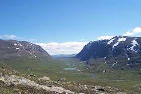 U-shaped valley of Syterskalet, dividing the Norra Storfjället mountain range | |
| Highest point | |
| Elevation | 1,768 m (5,801 ft) |
| Coordinates | 65°52′59″N 15°14′00″E / 65.883056°N 15.233333°ECoordinates: 65°52′59″N 15°14′00″E / 65.883056°N 15.233333°E |
| Geography | |
| Location | Laponie, Sweden |
| Parent range | Scandavian Mountains |
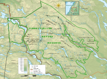
Norra Storfjället is a mountain range located in the county of Västerbotten, in Laponie Sweden. The mountain range is, for the most part, located within Vindelfjällens Nature Reserve. It reaches a maximum height of 1,768 m at the peak known as Norra Sytertoppen.[1] Other peaks include Måskostjakke (1,690 m) and Södra Sytertoppen (1,685 m).[1] It is divided approximately in half by a deep valley, the valley of Syterskalet/Viterskalet. This U-shaped valley is one of the renowned natural icons of the reserve and is remarkable similar to the Lapporten located 700 km to the north. A ski area lies on the southeast side of the massif , near Hemavan.
Gallery
-
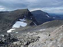
Södra Sytertoppen in the foreground and Norra Sytertoppen in the background.
-

Norra Sytertoppen, the highest point of the Norra Storfjället mountain range.
-

View of Norra Storfjället from a distance