Nor'Wester Mountains
| Nor'Wester Mountains | |
|---|---|
|
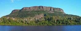
The Nor'Westers seen from Neebing Township | |
| Highest point | |
| Peak | Mount McKay |
| Elevation | 483 m (1,585 ft) |
| Coordinates | 48°20′43″N 89°17′8″W / 48.34528°N 89.28556°WCoordinates: 48°20′43″N 89°17′8″W / 48.34528°N 89.28556°W |
| Geography | |
| Country | Canada |
| Province | Ontario |

Mount McKay
The Nor'Wester Mountains are a group of mountains immediately south of Thunder Bay, Ontario, Canada, located on the southern limits of the City of Thunder Bay and south of the Kaministiquia River.[1]:32,33 Mount McKay is the highest, most northern and best known of these mountains. Other prominent peaks include Godfrey, Hurlburt, Johnson, Matchett, McRae, McQuaig, Rose, and Squaretop.
Loch Lomond, 287 m (942 ft) above sea level, collects most of the runoff within the Nor’Wester Mountains; Loch Lomond is drained by the Lomond River.[1]:5 A few square kilometers of mountain slope south of Mount McKay are drained by Whiskeyjack Creek.[1]:5
References
- 1 2 3 Watershed Characterization Report Lakehead Source Protection Area (PDF) (Report). Source Water Protection–Lakehead Region. March 2008. Retrieved June 14, 2010.
External links
This article is issued from Wikipedia - version of the 10/5/2015. The text is available under the Creative Commons Attribution/Share Alike but additional terms may apply for the media files.