Noorderhaaks
|
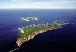
Noorderhaaks seen from the mainland | |
| Geography | |
|---|---|
| Coordinates | 52°58′30″N 4°40′50″E / 52.97500°N 4.68056°ECoordinates: 52°58′30″N 4°40′50″E / 52.97500°N 4.68056°E |
| Archipelago | (West) Frisian Islands |
| Adjacent bodies of water | North Sea |
| Administration | |
|
Netherlands | |
| Province | North Holland |
| Municipality | Texel |
| Demographics | |
| Population | Uninhabited |

Noorderhaaks (Dutch pronunciation: [ˌnoːrdərˈɦaːks]), also called Razende bol (Raging ball in Dutch), is an uninhabited Dutch island[1] in the North Sea, a few kilometres west of the Marsdiep which separates the island of Texel from mainland Netherlands. The island covers an area of around five km², although the exact area varies due to tide and the dynamic nature of the area.

Satellite photo of Noorderhaaks (left)
Being relatively untouched by man, the island has become a valuable location due to its presence of several kinds of seabirds, and seals.
The island is slowly moving eastward towards the Marsdiep and the Molengat, at a pace of around 100 metres a year.[1]
The island is visited by day trippers, and is also being used as a training ground for the Dutch navy and air force.
References
- 1 2 (Dutch) "Zandplaat De Razende Bol voortaan eiland", Nederlands Dagblad, 2003.
External links
-
 Media related to Noorderhaaks at Wikimedia Commons
| West Frisian Islands (Netherlands) |
|  | |||||||||
|---|---|---|---|---|---|---|---|---|---|---|---|
| East Frisian Islands (Germany) |
| ||||||||||
| Heligoland Bight (Germany) | |||||||||||
| North Frisian Islands (Germany) |
| ||||||||||
| Danish Wadden Sea Islands (Denmark) |
| ||||||||||
This article is issued from Wikipedia - version of the 11/24/2016. The text is available under the Creative Commons Attribution/Share Alike but additional terms may apply for the media files.