Nong Bua Lamphu Province
| Nong Bua Lam Phu หนองบัวลำภู | ||
|---|---|---|
| Province | ||
| ||
 Map of Thailand highlighting Nong Bua Lam Phu Province | ||
| Country |
| |
| Capital | Nong Bua Lam Phu | |
| Government | ||
| • Governor | Thanakorn Ungjitpaisan (since October 2016) | |
| Area | ||
| • Total | 3,859 km2 (1,490 sq mi) | |
| Area rank | Ranked 55th | |
| Population (2014) | ||
| • Total | 508,864 | |
| • Rank | Ranked 51st | |
| • Density | 130/km2 (340/sq mi) | |
| • Density rank | Ranked 33rd | |
| Time zone | ICT (UTC+7) | |
| ISO 3166 code | TH-39 | |

Nong Bua Lam Phu (Thai: หนองบัวลำภู, pronounced [nɔ̌ːŋ būa lām pʰūː]) is one of the northeastern provinces (changwat) of Thailand. Neighbouring provinces are (from north clockwise) Udon Thani, Khon Kaen, and Loei.
Geography
Nong Bua Lam Phu is in the heart of the Khorat Plateau.
Archaeological remains
Chalawan, an extinct genus of crocodylin, is known solely from its holotype collected in the early 1980s from a road-cut near the town of Nong Bua Lam Phu, in the upper part of the Phu Kradung Formation. This single specimen is the most well preserved vertebrate fossil that has been found from the formation. It contains a single species, Chalawan thailandicus.[1]
History
Nong Bua Lam Phu is famous as the spot where in the 16th century Naresuan, the king-liberator of Siam, came to learn of the outcome of a war between the Lao and Burmese in the area of Vientiane. This place was long a Lao stronghold. During the existence of the Lao kingdom of Lan Xang (1354–1707), Nong Bua Lam Phu was traditionally given to the crown prince (Uparat) to rule. It was the birthplace of the principal wife of Chao Siribunyasan (พระเจ้าศิริบุญสาร), the last independent king of Vientiane.[2] In 1827, Chao Anou of Vientiane designated Phagna Narin to be governor at the onset of the Laotian Rebellion of 1826-1828.
Under Thai rule, the province originally consisted of five amphoe (districts) in Udon Thani Province. In 1993 Udon was decentralized and a separate province of Nong Bua Lam Phu was created. It is one of the newest provinces of Thailand, together with Amnat Charoen Province, Sa Kaeo Province, and Bueng Kan Province.
Symbols
| The seal of the province shows King Naresuan in a shrine. This shrine was built to commemorate the visit of King Naresuan to the city of Nong Bua Lam Phu in 1574 when he was gathering troops to fight the Burmese kingdom of Taungoo. Behind the shrine is a pond with lotus flowers (Nymphaea lotus), which is the provincial flower. The provincial tree is the Siamese rosewood (Dalbergia cochinchinensis), |
Administrative divisions
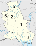
The province is subdivided into six districts (amphoe). The districts are further subdivided into 59 sub-districts (tambon) and 636 villages (muban).
References
- ↑ Martin, J. E.; Lauprasert, K.; Buffetaut, E.; Liard, R.; Suteethorn, V. (2013). Angielczyk, Kenneth, ed. "A large pholidosaurid in the Phu Kradung Formation of north-eastern Thailand". Palaeontology: n/a. doi:10.1111/pala.12086.
- ↑ Mayurī Ngaosīvat; Pheuiphanh Ngaosyvathn. "I. The Fabric of History. 1. Lao And Thai Contemporaries Of The Drama Speak Out". Paths to conflagration: fifty years of diplomacy and warfare in Laos, Thailand, and Vietnam, 1778–1828. Cornell University: Southeast Asia Program. ISBN 0877277230. Retrieved 24 June 2013.
Born to Siribunyasan (r. 1760-1779), the last independent king of Vientiane, and a princess from the principality of Nong Bua Lam Phu, Chao Anou eventually presided as monarch over both sides of the Mekong River
External links
- Province page from the Tourist Authority of Thailand
- Website of province (Thai only)
- Nong Bua Lam Phu provincial map, coat of arms and postal stamp
 |
Udon Thani Province | | ||
| Loei Province | |
|||
| ||||
| | ||||
| Khon Kaen Province |
Coordinates: 17°10′N 102°23′E / 17.167°N 102.383°E