Nogi, Tochigi
| Nogi 野木町 | |||
|---|---|---|---|
| Town | |||
|
Nogi Town Office | |||
| |||
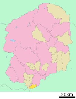 Location of Nogi in Tochigi Prefecture | |||
 Nogi
| |||
| Coordinates: 36°13′59.7″N 139°44′26.6″E / 36.233250°N 139.740722°ECoordinates: 36°13′59.7″N 139°44′26.6″E / 36.233250°N 139.740722°E | |||
| Country | Japan | ||
| Region | Kantō | ||
| Prefecture | Tochigi Prefecture | ||
| District | Shimotsuga | ||
| Area | |||
| • Total | 30.26 km2 (11.68 sq mi) | ||
| Population (May 2015) | |||
| • Total | 25,331 | ||
| • Density | 837/km2 (2,170/sq mi) | ||
| Time zone | Japan Standard Time (UTC+9) | ||
| - Tree | Pagoda Tree | ||
| - Flower | Sunflower | ||
| Address | Ōaza Marubayashi 571, Nogi-machi, Shimotsuga-gun, Tochigi-ken 329-0195 | ||
| Website | Official website | ||


Nogi (野木町 Nogi-machi) is a town located in Shimotsuga District, Tochigi Prefecture, in the northern Kantō region of Japan. As of May 2015, the town had an estimated population of 25,331 and a population density of 837 persons per km². Its total area was 30.26 km².
Geography
Nogi is located in the flatlands in the far southeast corner of Tochigi Prefecture.
Surrounding municipalities
History
During the Edo period, Nogi-shuku was a post station on the Nikkō Kaidō highway connecting Edo with the shrines at Nikkō, located within Koga Domain. After the Meiji restoration, the area of Nogi was initially part of Ibaraki Prefecture, but was transferred to Tochigi Prefecture on November 14, 1871. Nogi village were created within Shimotsuga District on April 1, 1889 with the creation of the municipalities system. It was elevated to town status on January 1, 1965.
Economy
The economy of Nogi is heavily dependent on agriculture.
Education
Nogi has five primary schools and two middle schools.
Transportation
Railway
Highway
Local attractions
- former Shimotsuke brickworks Hoffman kiln (national Important Cultural Property)
- Nogi Jinja
External links
![]() Media related to Nogi, Tochigi at Wikimedia Commons
Media related to Nogi, Tochigi at Wikimedia Commons
- Official website (Japanese)