Noddle's Island
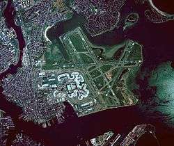
Noddle's Island was historically one of the Boston Harbor Islands off Boston, Massachusetts. Most of the original land of Noddle's Island now makes up the southern part of the neighborhood of East Boston; it is now part of the mainland since the strait connecting Noddle's Island to Hog Island and that connecting Hog Island to the mainland city of Revere were filled in the early 20th century. The original contours of Noddle's Island were also greatly obscured by the 20th-century construction of Logan International Airport, which filled the tidal flats between Noddle's Island and Governor's, Bird, and Apple islands to its east.
History
For over three hundred years, the island was known as Noddle's Island, for William Noddle, who was probably sent out by John Brereton, and settled upon it in the 1620s, before Boston was established by the Puritans. The island was used for grazing livestock and there was a fortified structure on the island. Mr. Noddle, a resident of Salem, died in 1632 when his canoe overturned on the South River, according to the journal of John Winthrop.[1] Sometime in the late 1620s or early 1630s, Rev. Samuel Maverick, an Anglican clergyman, became the owner of the island through his wife's inheritance from her deceased first husband, David Thompson, who had been part of the Sir Ferdinando Gorges expedition in the 1620s. The First Baptist Church of Boston met secretly on the island in the 17th century to avoid persecution by the Puritan state. During the American Revolutionary War "on this same island was fought the second battle of the Revolution [also known as the Battle of Chelsea Creek ], and the first in which the American artillery was used."[2] After the British left Boston harbor, the island was used as a hospital for the French Fleet in 1780 who dubbed it ""L'ile de France'" and buried numerous troops on the island. After this the island was heavily fortified by the Bostonians.
Most of the island's land area was built up in the 19th century, both for industrial uses (notably shipbuilding) and in the creation of residential neighborhoods such as Eagle Hill and Jeffries Point.
See also
References
External links
| ||||||||||||||||||||||||||||||||||