Ninohe District, Iwate

colored area=original extent in Meiji period; green=present area; beige=area transferred to Iwate District
Ninohe (二戸郡 Ninohe-gun) is a rural district located in Iwate Prefecture, Japan.
As of February 2014, the district has an estimated population of 13,392 and an area of 300.11 km². The entire city of Ninohe, and parts of the city of Hachimantai and town of Kuzumaki were formerly part of Ninohe District.
Towns and villages
The district consists of one town:
History
The ancient county of Nukanobu (糠部郡 Nikanobu-gun) in Mutsu Province was divided into the counties of Ninohe, Sannohe, Kunohe and Kita in 1634. Under the Tokugawa shogunate, Ninohe county consisted of 74 villages under the control of Morioka Domain. Following the Meiji restoration, Ninohe came under Aomori Prefecture from December 1871 to May 1876, when it became part of Iwate Prefecture.
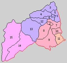
Purple= Ninohe City
1. Fukuoka; 3. Kindaichi; 4. Tomai; 5. Nissatai; 6. Ishikiridokoro; 12. Gohenji; 13. Jōbōji;
Peach=Ichinohe Town
2. Ichinohe; 7. Namiuta; 8. Chōkai; 9. Kozuya; 10. Anetai;
Orange=Kuzumaki Town
11. Tabe;
Red=Hachimantai City
14. Arasawa; 15. Tayama;
Timeline
- April 1, 1889 – With the establishment of the municipality system, Ninohe was organized into two 2 towns (Fukuoka and Ichinohe) and 13 villages)
- Town of Fukuoka, villages of Kintaichi, Tomai, Nisattai, Ishikiridokoro, Gohenji, and Jōbōji (now the city of Ninohe)
- Town of Ichinohe, villages of Namiutai, Chōkai, Anetai, and Kozuya (now the town of Ichinohe)
- Village of Arazawa and Tayama (now the city of Hachimantai)
- Village of Tabe (now the town of Kuzumak)
- December 25, 1940 - Jōbōji was raised to town status (3 towns, 12 villages)
- March 10, 1955 - The town of Fukuoka annexed the villages of Tomai, Nisattai, Ishikiridokoro, and Gohenji. (3 towns, 8 villages)
- July 5, 1955 - The village of Tabe merged with the town of Kuzumaki and the village of Ekari in Iwate District. (3 towns, 7 villages)
- September 30, 1956 - The villages of Arazawa and Tayama merged to form the town of Ashiro. (4 towns, 5 villages)
- November 1, 1957 - The town of Ichinohe annexed the villages of Namiuchi?(浪打), Chōkai, Anetai, and Kozuya. (4 towns, 1 village)
- April 1, 1972 - The town of Fukuoka and the village of Kintaichi merged to form the city of Ninohe. (3 towns)
- April 1, 2002 - The town of Ashiro transferred to Iwate District. (2 towns)
- January 1, 2006 - The town of Jōbōji was annexed by the city of Ninohe. (1 town)
| Core city | ||
|---|---|---|
| Cities | ||
| Isawa District | ||
| Iwate District | ||
| Kamihei District | ||
| Kesen District | ||
| Kunohe District | ||
| Ninohe District | ||
| Nishiiwai District | ||
| Shimohei District | ||
| Shiwa District | ||
| Waga District | ||
Coordinates: 40°16′N 141°16′E / 40.267°N 141.267°E