Nikaidō
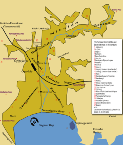
Nikaidō (二階堂) is the name of one of the administrative units ("towns", chō or machi) of Kamakura, a city located in Kanagawa, Japan, about 50 km south-south-west of Tokyo. Nikaidō lies immediately to the east of Nishi Mikado and Yukinoshita,[1] and used to be called Higashi Mikado.[2] The name is still sometimes used. In it lie famous temples and shrines like Zuisen-ji, Egara Tenjinsha, Kamakura-gū and Kakuon-ji.[3] It's in Nikaidō that first Kamakura shogun Minamoto no Yoritomo built Yōfuku-ji (永福寺),[4] one of his most important temples. It was probably part, together with Yukinoshita, of the Ōkura Valley that gave its name to the Ōkura Bakufu, Yoritomo's first government.[3]
Etymology of the name
After his wars with the Taira clan and Ōshū's Fujiwara clan, in 1189 shogun Yoritomo founded a temple called Yōfuku-ji to comfort the souls of the samurai that had died in them.[5] The temple was erected in a location next to today's Kamakura-gū. Its main hall was a two-story building called Nikaidō, which was copied from Chuson-ji's Daichō-in Nikaidō (大寿院二階堂) in Hiraizumi, a building the shogun had greatly admired.[5] In time, that famous building gave its name to the entire area where it stood.[5] According to another theory, however, the name comes from that of an important clan vassal of the Minamoto, also called Nikaidō, because that's where the clan's mansion used to stand.[3]
Yōfuku-ji was expanded several times, finally becoming a great temple with many pavilions and a great artificial lake. It was often visited by Yoritomo, his wife Hōjō Masako, and their descendants, who liked spending time there.[3][5] The temple no longer exists, but exactly when and how it was destroyed isn't known.[5] We do know that at the end of the Muromachi period it stopped appearing in written records[5] and that it burned down many times, the last we know of in 1405.[3] The area where it used to stand is now public property, and the city of Kamakura plans to turn it into an historical park.[5]
External links
- Yōfuku-ji, site dedicated to the temple, with CG reconstructions of its main structures (Japanese)
Notes
- ↑ For its exact administrative boundaries, see this map
- ↑ See the stele in Higashi Mikado (Japanese)
- 1 2 3 4 5 Shirai (1976:231)
- ↑ Note that these characters are more often read Eifuku-ji, and that Japanese themselves in this particular case often pronounce them incorrectly.
- 1 2 3 4 5 6 7 Kusumoto (2002:44-45)
References
- Kusumoto, Katsuji (July 2002). Kamakura Naruhodo Jiten (in Japanese). Tokyo: Jitsugyō no Nihonsha. ISBN 978-4-408-00779-3. OCLC 166909395.
- Kamakura Shōkō Kaigijo (2008). Kamakura Kankō Bunka Kentei Kōshiki Tekisutobukku (in Japanese). Kamakura: Kamakura Shunshūsha. ISBN 978-4-7740-0386-3.
- Papinot, Edmond (1910). Historical and Geographical Dictionary of Japan (Japanese Edition). Tuttle. ISBN 0-8048-0996-8.
- Shirai, Eiji (1976). Kamakura Jiten (in Japanese). Tōkyōdō Shuppan. ISBN 4-490-10303-4.
Coordinates: 35°19′20.34″N 139°33′57.99″E / 35.3223167°N 139.5661083°E