Niers
| Niers | |
|---|---|
 The Niers at Weeze | |
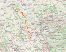 Overview map | |
| Country | Germany, Netherlands |
| Basin | |
| Main source |
Lower Rhine region ±75 m (246 ft) 51°04′49″N 6°23′31″E / 51.08028°N 6.39194°E |
| River mouth |
Maas 51°42′50″N 5°56′51″E / 51.71389°N 5.94750°ECoordinates: 51°42′50″N 5°56′51″E / 51.71389°N 5.94750°E |
| Basin size | 1,348 km2 (520 sq mi) |
| Physical characteristics | |
| Length | 116 km (72 mi) |
The Niers (pronounced like neerce) is a river in Germany and the Netherlands, right tributary to the river Meuse. Its source is near Erkelenz, south of Mönchengladbach, in North Rhine-Westphalia (Germany). The Niers flows through Mönchengladbach, Viersen, Wachtendonk, Geldern and Goch before flowing into the Meuse just across the border with the Netherlands, in Gennep. Its total length is 116 km - 108 km in Germany, 8 km in the Netherlands.
External links
This article is issued from Wikipedia - version of the 9/1/2016. The text is available under the Creative Commons Attribution/Share Alike but additional terms may apply for the media files.