Newtown Township, Delaware County, Pennsylvania
| Newtown Township | ||
| Township | ||
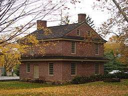 The Square Tavern | ||
|
||
| Country | United States | |
|---|---|---|
| State | Pennsylvania | |
| County | Delaware | |
| Elevation | 384 ft (117.0 m) | |
| Coordinates | 39°59′25″N 75°24′14″W / 39.99028°N 75.40389°WCoordinates: 39°59′25″N 75°24′14″W / 39.99028°N 75.40389°W | |
| Area | 10.1 sq mi (26.2 km2) | |
| - land | 10.0 sq mi (26 km2) | |
| - water | 0.1 sq mi (0 km2), 0.99% | |
| Population | 12,216 (2010) | |
| Density | 1,166.0/sq mi (450.2/km2) | |
| Settled | 1681 | |
| - Incorporated | 1684 | |
| Timezone | EST (UTC-5) | |
| - summer (DST) | EDT (UTC-4) | |
| ZIP Code | 19073 | |
| Area code | 610 and 484 | |
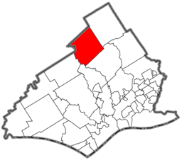 Location of Newtown Township in Delaware County | ||
 Location of Newtown Township in Pennsylvania | ||
 Location of Pennsylvania in the United States | ||
| Website: http://www.newtowntownship.org | ||

Newtown Township is a township in Delaware County, Pennsylvania, United States. Prior to 1789 it was part of Chester County.[1] Including its history as part of Chester County, it is the oldest township in Delaware County. The population was 12,216 as of the 2010 census.
History
Newtown Square was the name used for the townstead with the majority of early settlers being Welshmen. These Welsh "Friends" (Quakers) needed a road to facilitate their journey to meeting, the only established road at the time being Newtown Street Road, which ran north and south. As such, in 1687, an east-west road was laid out (Goshen Road) so the Friends could attend either Goshen or Haverford Meeting. By 1696, these friends had become numerous enough to hold their own meeting in Newtown and continued to meet in a private home until the completion of the Newtown Friends Meetinghouse in 1711. In the 18th century, Newtown was basically a farming community. Blacksmith and wheelwright shops emerged on the main arteries to service horse and buggy travelers. Taverns and inns were also opened to accommodate local patrons as well as drovers taking their livestock to the markets in Philadelphia.
During the 19th century a number of mills sprang up along Crum Creek (the western border) and Darby Creek (in the northeast corner of the Township). These included saw mills, paper mills, shingle mills, and a woolen factory. In the Darby Creek area a number of tenement houses were built as well as a general store to service the needs of the mill workers.
In 1860, the population of Newtown Township was 830; the population of Philadelphia was approximately half a million. At this time, the railroad, so called the "Iron horse," was laying track out of Philadelphia in all directions with service to Chester, Media, West Chester, and Radnor ... but not Newtown Square. As these towns, as well as stops along the way, grew and prospered, mills closed and businesses declined in Newtown Square. By 1890, the population had fallen to 648.
As an agricultural community, stone farmhouses graced the country landscape throughout the 19th century. Additions were made to the early simple dwellings as families grew and more living space was required. Prosperity, due to a growing market, also enabled property owners to make additions, not only to their own homes, but on the property as well as in the form of tenements and outbuildings.
In 1859, the Rose Tree Hunt Club was organized south of the township, followed by the Lima Hunt Club to the west (1885) and the Radnor Hunt Club at the intersection of Darby-Paoli and Goshen Roads in 1886. With these developments, many country estates were built in the rolling hills of Newtown Square for "...either country gentlemen of Old Quaker blood...or rich Philadelphians who loved hunting, owned good horses, and were not afraid to ride them." Major transportation developments for the Township did not occur until the mid-1890s, when trolley service was opened to Newtown Square. Before this time, railroad lines had been proposed, but due to a series of reorganizations and competition between companies for right-of-ways as of 1892, no track had been laid. In 1894, however, mule-drawn service was initiated by the Philadelphia and Delaware County Railroad, with steam dummies used to help out on the hills. Electrification was completed the following year and the trolley was open from Newtown to Fernwood in 1895. By 1889, the reorganized Philadelphia and West Chester Traction Company had completed the track to West Chester.
Aronimink Golf Club, which has hosted the 1962 PGA Championship, the 1977 U.S. Amateur, the 1997 U.S. Junior Amateur Championship, 2003 Senior PGA Championship, and the 2010 and 2011 AT&T National is in Newtown Township.
At the turn of the 20th century, the automobile began to disperse the urban populations over the countryside. The trolleys, along with the new "horseless carriage," transformed the country farmers into suburban commuters. Farms were sold and the land subdivided. Newtown Square boomed. Many city dwellers retained their country estates, however, these became hidden amidst gridiron developments. Although construction slackened during the depression, another boom was experienced after World War II.
Today Newtown Township has a land area of 10.11 square miles (26.2 km2), and a population of 12,216 individuals. Some farms and large estates remain, but for the most part, the township was developed into a suburban community with old stone homes and structures dotting the landscape to serve as reminders of days gone by.
Historic sites
Five sites in Newtown are listed on the National Register of Historic Places:
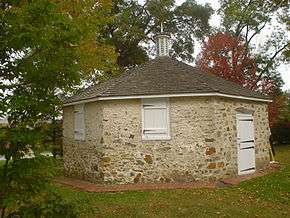
- Hood Octagonal School (1842) – the last 8-sided one-room school house in Delaware County. Located on West Chester Pike on the grounds of Dunwoody Village.
- Bartram's Covered Bridge (1860) – the last remaining covered bridge in Delaware County (spanning Crum Creek – connecting with Chester County), located at Goshen and Boot roads. Restored in 1996.
- Old. St. David's Church (1715) – the oldest non-Quaker church in Delaware County, founded by Welsh Anglicans; burial place of General "Mad" Anthony Wayne, located on S. Valley Forge Road in the very corner of the Township. In March 1880, Henry Wadsworth Longfellow attended the church and wrote the poem "Old St. David's at Radnor."[2]
- Square Tavern (1742) – also known as "The Square Inn" and "John West House" – the childhood site of famous American painter Benjamin West, restored in 1981 and again in 2008, located at the corner of Newtown Street Road (Rt. 252) and Goshen Roads.
- Paper Mill House (1770, 1845) – mill workers home and general store, restored in the 1980s and now used as museum and headquarters for the Newtown Square Historical Society. Located at St. David's and Paper Mill Roads.
Geography

According to the United States Census Bureau, the township has a total area of 10.1 square miles (26 km2), of which, 10.0 square miles (26 km2) of it is land and 0.1 square miles (0.26 km2) of it (0.69%) is water. Its villages include Echo Valley, Florida Park, Larchmont (also in Marple Township,) Newtown Square, and Wyola.
Adjacent municipalities
- Radnor Township – northeast
- Marple Township – southeast
- Upper Providence Township – south
- Edgmont Township – southwest
- Willistown Township, Chester County – west
- Easttown Township, Chester County – northwest
Demographics
| Historical population | |||
|---|---|---|---|
| Census | Pop. | %± | |
| 1930 | 1,541 | — | |
| 1940 | 1,949 | 26.5% | |
| 1950 | 3,518 | 80.5% | |
| 1960 | 9,270 | 163.5% | |
| 1970 | 11,081 | 19.5% | |
| 1980 | 11,775 | 6.3% | |
| 1990 | 11,366 | −3.5% | |
| 2000 | 11,700 | 2.9% | |
| http://www.dvrpc.org/data/databull/rdb/db82/appedixa.xls. | |||
As of the census[3] of 2000, there were 11,700 people, 4,549 households, and 3,184 families residing in the township. The population density was 1,166.0 people per square mile (450.4/km2). There were 4,690 housing units at an average density of 467.4 per square mile (180.5/km2). The racial makeup of the township was 96.16% White, 0.66% African American, 0.07% Native American, 2.30% Asian, 0.13% from other races, and 0.68% from two or more races. Hispanic or Latino of any race were 0.69% of the population.
There were 4,549 households, out of which 27.6% had children under the age of 18 living with them, 60.4% were married couples living together, 7.2% had a female householder with no husband present, and 30.0% were non-families. 27.2% of all households were made up of individuals, and 15.9% had someone living alone who was 65 years of age or older. The average household size was 2.50 and the average family size was 3.06.
In the township the population was spread out, with 23.1% under the age of 18, 4.9% from 18 to 24, 24.4% from 25 to 44, 25.6% from 45 to 64, and 21.9% who were 65 years of age or older. The median age was 43 years. For every 100 females there were 88.9 males. For every 100 females age 18 and over, there were 83.2 males.
The median income for a household in the township was $65,924, and the median income for a family was $82,557. Males had a median income of $61,688 versus $37,319 for females. The per capita income for the township was $39,364. About 1.8% of families and 3.5% of the population were below the poverty line, including 2.6% of those under age 18 and 3.9% of those age 65 or over.
Arts and culture
Places of worship include St. David's Episcopal Church, whose graveyard and buildings begin in 1715, are listed on the National Register of Historic Places. The graveyard contains one of the graves of Revolutionary War hero General Mad Anthony Wayne.[4][5] The Newtown Square Friends Meeting House and Burying Ground is the oldest place of worship in Newtown. The original Quaker settlers built the Meeting House in 1711, and then it was greatly expanded and "modernized" in 1791. The architectural ghost of the original 1711 doorway and one of the original windows can be seen in the stone infill in the north wall of the expanded Meeting House. The Meeting House is still in use for worship on "First Day". Saint Anastasia Parish was founded in 1912 to serve the small Catholic population. In 1930, a Catholic school was opened. Post-World War II, the church and school expanded to serve the rapidly growing Catholic population of Newtown Square.[6]
Economy
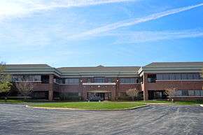
The township is home to the Project Management Institute (PMI), a Lyondell Chemical Company Technology Center, and Apple Leisure Group, which also includes AMResorts and Apple Vacations.[7][8][9] It is also the home of the headquarters for SAP America, a subsidiary of SAP SE.[10]
References
- ↑ Newtown Township History
- ↑ Henry Wadsworth Longfellow, read by Grover Gardner (April 4, 2008). Old St. David's at Radnor (https://www.youtube.com/watch?v=Oc_s6jXdwak). Youtube: West Production Services.
- ↑ "American FactFinder". United States Census Bureau. Archived from the original on 2013-09-11. Retrieved 2008-01-31.
- ↑ St. David’s Church: Who We Are: History.
- ↑ "Item No.:78002394 NRIS (National Register Information System)". National Park Service. Retrieved 2008-09-26.
- ↑ "History - St. Anastasia Church - Newtown Square, PA". saintanastasia.net. Retrieved 2016-02-03.
- ↑ "uipl_3002c2a3.html." United States Department of Labor. Retrieved on May 26, 2009.
- ↑ "Contact us." USA3000 Airlines. Retrieved on October 1, 2010. "Head Office Mailing Address USA3000 Airlines 335 Bishop Hollow Rd Newtown Square, PA 19073"
- ↑ "Newtown township, Delaware County, PA." U.S. Census Bureau. Retrieved on October 1, 2010.
- ↑ "sap.com Worldwide Office Directory." Retrieved on January 6, 2011.
External links
| Wikimedia Commons has media related to Newtown Square, Pennsylvania. |
- Newtown Township
- Newtown Township @DelawareCountyPA.com
- Newtown Square Fire Company
- Newtown Square Historical Preservation Society
Municipalities and communities of Delaware County, Pennsylvania, United States | ||
|---|---|---|
| City |  | |
| Boroughs | ||
| Townships | ||
| CDPs | ||
| Unincorporated communities |
| |
| Footnotes | ‡This populated place also has portions in an adjacent county or counties | |