Newport station (PATH)
| |||||||||||||||||||||||||||||||||||||||||||
|---|---|---|---|---|---|---|---|---|---|---|---|---|---|---|---|---|---|---|---|---|---|---|---|---|---|---|---|---|---|---|---|---|---|---|---|---|---|---|---|---|---|---|---|
 The underground station platform, when it was Pavonia-Newport | |||||||||||||||||||||||||||||||||||||||||||
| Location |
Washington Boulevard and Town Square Place (formerly Pavonia Avenue) Newport, Jersey City, New Jersey | ||||||||||||||||||||||||||||||||||||||||||
| Coordinates | 40°43′36″N 74°02′05″W / 40.726676°N 74.034757°WCoordinates: 40°43′36″N 74°02′05″W / 40.726676°N 74.034757°W | ||||||||||||||||||||||||||||||||||||||||||
| Owned by | Port Authority of New York and New Jersey | ||||||||||||||||||||||||||||||||||||||||||
| Line(s) | |||||||||||||||||||||||||||||||||||||||||||
| Platforms |
1 island platform (southbound only) 1 side platform (northbound only) | ||||||||||||||||||||||||||||||||||||||||||
| Tracks | 2 | ||||||||||||||||||||||||||||||||||||||||||
| Connections |
HBLR at Pavonia-Newport | ||||||||||||||||||||||||||||||||||||||||||
| Construction | |||||||||||||||||||||||||||||||||||||||||||
| Parking | Parking garages available in area | ||||||||||||||||||||||||||||||||||||||||||
| Disabled access | Yes | ||||||||||||||||||||||||||||||||||||||||||
| History | |||||||||||||||||||||||||||||||||||||||||||
| Opened | 1909 | ||||||||||||||||||||||||||||||||||||||||||
| Electrified | 600V (DC) Third Rail | ||||||||||||||||||||||||||||||||||||||||||
| Previous names |
Erie (1909-1962) Pavonia Avenue (1962-1988) Pavonia (Alt. name; 1962-1988) Pavonia/Newport (1988-2010) | ||||||||||||||||||||||||||||||||||||||||||
| Traffic | |||||||||||||||||||||||||||||||||||||||||||
| Passengers (2015) |
5,750,188[1] | ||||||||||||||||||||||||||||||||||||||||||
| Services | |||||||||||||||||||||||||||||||||||||||||||
| |||||||||||||||||||||||||||||||||||||||||||
Newport (formerly known as Pavonia – Newport, Pavonia, or Erie) is a PATH station located on Town Square Place (formerly Pavonia Avenue) at the corner of Washington Boulevard in Newport, Jersey City, New Jersey.
History
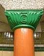
The station was opened on August 2, 1909 as part of the Hudson and Manhattan Railroad (H&M), originally constructed to connect to the Erie Railroad's Pavonia Terminal.[2] The capitals of the station's columns are adorned with the "E", and recall its original name, Erie. After the Port Authority of New York and New Jersey 1960s takeover of the system, the station was renamed Pavonia, or Pavonia Avenue,[3] itself named for the 17th New Netherland settlement of Pavonia. In 1988, the station became known as Pavonia/Newport to reflect the re-development of the former railyards along the banks of the Hudson River to residential, retail, and recreational uses as Newport.[3] In 2010, the name became Newport.[4]
The station has undergone a number of transformations. During the Erie period, the station was so busy that a second platform was added to manage the flow of passengers from the over 30 passenger trains that ran in and out of the station hourly. The desire to reuse old caissons (from previous tunneling attempts) when building the H&M system meant that the tubes at this location were located far inland. As a result, the actual station was not closely integrated into the Erie Railroad Terminal above, and the Erie never built a new terminal on top of the underground platforms. Therefore, a lengthy walk through inclined pedestrian tunnels was necessary in order to connect from the H&M to the passenger trains. In response to this, in 1954, the Hudson and Manhattan Railroad installed a 277-foot (84 m) long moving sidewalk known as "the Speedwalk". It was the first such moving walkway built in the United States; built by Goodyear, it moved up a 10 percent grade at a speed of 1.5 mph (2.4 km/h).[5][6] The walkway was closed within a decade due to significant changes happening above ground. It remained in place until the mid-1990s when the station was completely refurbished in response to the new office and commercial development in the area.
In 1956, the Erie Railroad consolidated its operations with the Lackawanna Railroad and moved to a terminal in Hoboken. A few years later, the small New York, Susquehanna and Western Railway ceased operations at the Erie Terminal, which was torn down soon afterwards.[7] Without any reason to disembark other than some parking lots, ridership at the Erie tube station declined sharply. For nearly 30 years, the station served primarily as a transfer station from one PATH line to another, and was totally closed on evenings and weekends. (At the former World Trade Center station in 2001, it was still possible to see the abandoned electronic board that indicated with a light whether the Pavonia Station stop was in service or not.)
Beginning in the late 1980s, the once-vacant railyards surrounding the station were turned into residential, office, and retail towers, and the neighborhood became known as Newport. As part of the redevelopment, Pavonia Station itself was renamed and underwent extensive renovations, including improved lighting, floors, walls, ceilings, artwork, and the installation of a new headhouse with escalators and elevators.[8] The station underwent further renovations in 2001–2003 with the installation of an additional elevator in order to re-open the side platform to regular use after four decades of inactivity.[9]
The open steelwork beside the headhouse is the skeleton for a never-built second level that was to connect to office towers across the street via a skywalk, similar to those at the Gateway complex at Newark Penn Station.
The Port Authority is currently considering whether to fund a long-proposed second entry to the station on the west side of Washington Boulevard to ease congestion.
Station layout
| G | Street Level | Exit/Entrance |
| B1 | Mezzanine | Fare control, one-way faregates |
| B2 Platform level |
Southbound | ← JSQ–33 toward Journal Square (Grove Street) ← JSQ–33 (via HOB) toward Journal Square (Grove Street) ← HOB–WTC toward World Trade Center (Exchange Place) |
| Island platform, doors will open on the left for southbound trains only | ||
| Northbound | → JSQ–33 toward 33rd Street (Christopher Street) → → JSQ–33 (via HOB) toward 33rd Street (Hoboken Terminal) → → HOB–WTC toward Hoboken Terminal (Terminus) → | |
| Side platform, doors will open on the right | ||
The station has two tracks. There is one island platform serving southbound trains and one side platform serving northbound trains.[10]
Service
As of 2010 it was estimated weekday use was between 17,000–18,000 passengers.[11][12] It is served by the Hoboken – World Trade Center and Journal Square – 33rd Street services. During daytime and evening hours, trains bound for Hoboken and 33rd Street use the side platform. The island platform is used for trains bound for the World Trade Center and Journal Square, and for all trains during overnight hours.
Vicinity

- Hudson River Waterfront Walkway
- Hudson and Manhattan Railroad Powerhouse
- Newport Centre Mall, mall with over 130 shops and 12 AMC Theaters
- Newport Tower, a 37-story office tower
- The James Monroe, a 34-story residential high-rise
References
- ↑ "PATH Ridership Report" (PDF). pathnynj.gov. Port Authority of New York and New Jersey. Retrieved 30 October 2016.
- ↑ "Tube Stations". hudsoncity.net. Retrieved 2006-04-14.
- 1 2 Brennan, Joseph (2001–2002). "Pavonia / Newport Platform". Abandoned Stations. Columbia.edu. Retrieved 2010-12-29.
- ↑ Hortillosa, Summer Dawn (January 3, 2011). "PATH train station signs changed as part of Port Authority's modernization project". NJ.com.
- ↑ "Passenger Conveyor Belt to Be Installed in Erie Station". New York Times. 1953-10-06. p. 31. Retrieved 2009-09-04.
- ↑ "Commuter "Walk" to Move Monday; Homeward-Bound Jerseyites Will Get a Lift at Hudson Tubes' Erie Station". The New York times. May 20, 1954. Retrieved 2013-01-08.
- ↑ Howe, Ward Allan (1956-09-30). "Railroads: Switch; Erie Will Share the Hoboken Terminal With Lackawanna Starting Oct. 13". New York Times. p. X29. Retrieved 2009-09-04.
- ↑ "PATH / Hudson & Manhattan RR". nycsubway.org. Retrieved 2006-04-14.
- ↑ "A bright New Side to PATH". PATH. Archived from the original on 2006-04-11. Retrieved 2006-04-14.
- ↑ Marrero, Robert (2015-09-13). "469 Stations, 846 Miles" (PDF). B24 Blog, via Dropbox. Retrieved 2015-10-09.
- ↑ "RFP# 20136 Attachment A: Background" (PDF) (Press release). Port Authority of New York and New Jersey. November 15, 2010. Retrieved 2010-12-30.
- ↑ Clark, Sara (November 19, 2010). "Japanese developers tour Jersey City's Newport as example of transit-oriented smart growth". Jersey Journal. Retrieved 2010-12-30.
External links
- PATH - Newport
- Hudson & Manhattan Railroad/Hudson Tubes
- Town Square Place entrance from Google Maps Street View
| Wikimedia Commons has media related to Newport (PATH station). |
| Services | 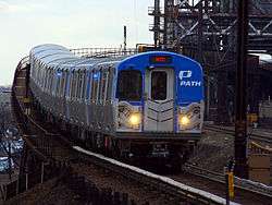 | |
|---|---|---|
| Stations | ||
| Infrastructure | ||
| Historical | ||
| Related | ||