Newmarket Viaduct

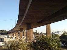
The Newmarket Viaduct, sometimes considered 'one of the most distinctive engineering features' of New Zealand,[1] is a seven-lane State highway viaduct in Auckland, the country's largest city. Carrying the Southern Motorway over the Newmarket suburb area southeast of the CBD of the city, the 700 m long viaduct is up to 20 m high in places. Due to concerns about its ability to withstand earthquakes and its increasing inability to cater for peaktime traffic demand, it is being replaced with a stronger and wider structure over several years, starting in 2009.
Original structure
The viaduct was opened on 3 September 1966 at a cost of NZ$2.26 million, and was constructed as New Zealand's first pair of balanced cantilever bridges.[2] With its long spans, the s-curvature and the varying superelevation of the motorway, it is a complex structure even today, and at the time was ground-breaking design for New Zealand.[3]
While considered a successful design, it was built to far lower earthquake standards than which other New Zealand structures now fulfill, being built to survive only a 1 in 500 year return period earthquake. It could have received significant damage in an earthquake as common as once in 200 years.[4] This made the structure the weakest strategic transport infrastructure link in the Auckland area, with a potential collapse cutting off all motorway transport to the South.[1] Also, during design, temperature stresses were not yet understood to a sufficient degree, leading to increased wear on structural elements.[2]
Plans for replacement
The limited earthquake stability, together with increasing traffic demands (over 200,000 vehicles a day, more than on the Auckland Harbour Bridge and the most traffic on a section of road anywhere in New Zealand),[5] led to the planning for a new viaduct structure, which will be able to withstand an earthquake with a 2,500 year return period. Other factors were the very low safety barriers (which once allowed an out-of-control truck to fall onto its roof 15 m below, in 2004), which are also insufficient to prevent debris from falling onto the properties beneath,[1] and the fact that the existing viaduct is a prohibited route for overweight vehicles, forcing more trucks through the city streets.[2]
Major maintenance of the existing structure was also considered as an option. However, the structural elements of the existing viaduct did not lend themselves to easy strengthening, and even a reconditioned viaduct would only have provided an estimated life expectancy of 40-50 more years. With a proposed new structure costing only around 15% more than a repair, and expected to last for over 100 years, it was decided to go for a full replacement.[2]
New structure
The new Transit New Zealand structure is estimated to cost NZ$ 150 million, and cleared planning hurdles quicker than expected, leading to hopes that it would be possible to build it in time for the 2011 Rugby World Cup. Originally, the three-year duration project was expected to start in 2009/2010. Factors that influenced the quick decision process were the lack of any archeological evidence in the construction area, as well as the lack of substantial numbers of residential properties affected by the new structure.[6]
Design
The new structure was to be constructed in a way to minimally affect the traffic flow on this crucial motorway link, by first constructing a new viaduct of four southbound lanes to the north-east of the existing structure, then demolishing the existing three southbound lanes, before constructing the three new northbound lanes in the gap and finally demolishing the three old northbound lanes. It was originally considered whether to build a 'steel box' or a 'concrete box' structure, though both would look similar to the existing viaduct structure.[1][7] It was eventually decided to construct a segmented structure built from 468 pre-cast concrete sections constructed off-site in East Tamaki, and moved into place with a lifting gantry truss.[8]
Tonkin + Taylor and URS New Zealand, as part of the Northern Gateway Alliance, were assigned to develop the new bridge, and one of their design targets includes full recycling of all material during the project. The consultant team is also to use the experience gained at the Waiwera Viaduct in this new project.[9] However, estimated costs in June 2008 had risen to NZ$187 million, and was unclear whether the funds can be made accessible quickly enough to achieve the ambitious schedule of finishing the bridge in time for the 2011 World Cup.[10] In October 2008, funding was confirmed, but the estimated price later increased to NZ$195 million, with rising prices for fuel, construction materials and labour cited as the reasons. While still ahead of schedule, only part of the viaduct replacement was completed in time for the Rugby World cup in 2011.[11]
The new viaduct features better noise protection for the surrounding communities, thanks to noise-absorbing asphalt, solid concrete crash barriers, and partial noise walls.[4] Some further urban design improvements will also be part of the project, such as a volcanic-themed walkway from Gillies Avenue down towards Newmarket (connecting to Clovernook Road).[12][13]


Construction
Construction began in earnest in April 2007, with the first foundations for the up to 18m high piers of the southbound part of the new viaduct. A bracing structure under the section carrying over the railway line was established over Easter 2009, and a 140m long, 800 ton heavy[14] launching gantry was erected above the Newmarket skyline, which will move into place new sections and stabilise parts to be demolished (with the demolition considered the most difficult part of the project). The southbound addition is to be finished by the end of 2010, while the northbound section will likely take at least until March 2012.[15] During construction, sight screens will reduce visual distractions of passing drivers, though the construction will still require narrowing of the traffic lanes and reduction of the maximum speed on the viaduct to 70km/h. A number of temporary support girders around the structure will also be required to safely cater for the stresses put on the structure while parts of it are demolished and rebuilt.[8]
Construction involved building the new southbound viaduct first, then demolition of the old southbound viaduct, followed by the construction of the new northbound section in the resulting gap, before the old northbound section is finally demolished. This ensured that except for short interruptions, normal motorway capacity will remain available throughout the construction period.[4] Further work will also take place around the viaduct, including the construction of a volcanic-themed walkway from Gillies Avenue to Broadway (via Clovernook Road) and an upgraded footbridge over State Highway 1 at Mt Hobson Road.[14]
The new viaduct is composed of 468 separate bridge deck sections, produced in a precast facility in East Tamaki.[12]
Over 150 people were employed directly by the project.[13]
Awards
The work on demolishing the old viaduct sections while the new sections were constructed directly adjacent won the Civils Demolition Award in the 2012 World Demolition Awards.[16]
References
- 1 2 3 4 Dearnaley, Mathew (18 June 2007). "Viaduct on track for World Cup". The New Zealand Herald. Retrieved 30 October 2011.
- 1 2 3 4 Frequently Asked Questions (from the project website of Transit New Zealand)
- ↑ Engineering to 1990 - IPENZ, Engineering Publications Co Ltd, Page 10
- 1 2 3 From Viaduct to Viaduct - e.nz magazine, IPENZ, November/9 December, Page 42
- ↑ SH1 Newmarket Viaduct - The New Zealand Herald, Saturday 30 June 2007, Page C6
- ↑ Archeological and Heritage Assessment (PDF) (Russell Foster and Associates, September 2005)
- ↑ Artist's concept impression of the proposed alignment (from the Transit New Zealand project website)
- 1 2 Newmarket Connection - Viaduct Replacement Newsletter, Issue 01, July 2009, Page 2
- ↑ "Newmarket Viaduct!" (Press release). Tonkin + Taylor. 8 August 2007. Retrieved 21 June 2008.
- ↑ Dearnaley, Mathew (16 June 2008). "Clear days hold up viaduct project". The New Zealand Herald. Retrieved 30 October 2011.
- ↑ "Green light for Newmarket Viaduct upgrade". Radio New Zealand. 3 October 2008. Retrieved 30 October 2011.
- 1 2 An urban design-integrated approach - Newmarket Connection, Viaduct Replacement Newsletter - NZTA, Issue 02, October 2009, Page 3
- 1 2 Barrat, Joseph (24 January 2010). "Viaduct paves way for boom". The New Zealand Herald. Retrieved 25 January 2010.
- 1 2 "Newmarket Connection: Viaduct Replacement Project Newsletter, Issue 03". April 2010.
- ↑ Dearnaley, Mathew (7 April 2009). "Engineers size up tricky bridgework". The New Zealand Herald. Retrieved 30 October 2011.
- ↑ "Best of the best". World Demolition Summit 2012 Conference. Retrieved 9 November 2012.
External links
| Wikimedia Commons has media related to Newmarket Viaduct. |
- Newmarket Connection (official project website, NZTA)
- [District] Plan Modification 193 (required for the new viaduct, includes various related reports, Auckland City Council)
Coordinates: 36°52′26″S 174°46′38″E / 36.873767°S 174.777095°E