Newbury, New Hampshire
| Newbury, New Hampshire | ||
|---|---|---|
| Town | ||
|
| ||
| ||
 Location in Merrimack County and the state of New Hampshire. | ||
| Coordinates: 43°19′17″N 72°02′09″W / 43.32139°N 72.03583°WCoordinates: 43°19′17″N 72°02′09″W / 43.32139°N 72.03583°W | ||
| Country | United States | |
| State | New Hampshire | |
| County | Merrimack | |
| Incorporated | 1772 | |
| Government | ||
| • Board of Selectmen |
Ed Thorson, Chair Joy Nowell Russ Smith | |
| • Town Administrator | Dennis Pavlicek | |
| Area | ||
| • Total | 38.1 sq mi (98.7 km2) | |
| • Land | 35.8 sq mi (92.7 km2) | |
| • Water | 2.3 sq mi (5.9 km2) 6.01% | |
| Elevation | 1,119 ft (341 m) | |
| Population (2010) | ||
| • Total | 2,072 | |
| • Density | 54/sq mi (21/km2) | |
| Time zone | Eastern (UTC-5) | |
| • Summer (DST) | Eastern (UTC-4) | |
| ZIP codes | 03255, 03272 | |
| Area code(s) | 603 | |
| FIPS code | 33-50900 | |
| GNIS feature ID | 0873675 | |
| Website | www.newburynh.org | |

Newbury is a town in Merrimack County, New Hampshire, United States. The population was 2,072 at the 2010 census.[1] Newbury is home to part of Lake Sunapee, including Mount Sunapee State Park Beach. Mount Sunapee Resort, a ski area in Mount Sunapee State Park, is in the west. The town includes the villages of Blodgett Landing and South Newbury.
History

Situated at the south end of Lake Sunapee, this town has gone through numerous name changes. It started in 1753 as "Dantzic", after the Baltic seaport. The first provincial grant in 1754 named the town "Hereford", in honor of Edward Devereaux, Viscount Hereford. Colonial Governor John Wentworth renewed the grant in 1772 under the name "Fishersfield", for his brother-in-law, John Fisher. The town was finally incorporated as "Newbury" in 1837, as suggested by settlers originally from Newbury, Massachusetts.
The Fells Historic Site, located adjacent to the John Hay National Wildlife Refuge, is part of 876 acres (3.55 km2) protected of a forest country estate. Protection efforts have enabled Lake Sunapee to consistently be named one of the cleanest lakes in the state.
Geography
According to the United States Census Bureau, the town has a total area of 38.1 square miles (99 km2), of which 35.8 sq mi (93 km2) is land and 2.3 sq mi (6.0 km2) is water, comprising 6.01% of the town. Mount Sunapee, the highest point in town, has an elevation of 2,726 feet (831 m) above sea level.
The village of Newbury is located at the south end of Lake Sunapee near the geographic center of the town. The village is at the junction of New Hampshire Route 103 and 103A. Route 103 leads northwest, past the entrance to Mount Sunapee Resort (a state park) and into the town of Sunapee. To the southeast, Route 103 passes the village of South Newbury before entering the town of Bradford. Route 103A proceeds north, parallel to the east shore of Lake Sunapee, and passes the village of Blodgett Landing before entering the town of New London.
The northern half of the town drains into Lake Sunapee, which in turns drains west via the Sugar River into the Connecticut River and thence to Long Island Sound. The southern half of the town, including the eastern side of Mount Sunapee, drains via Andrew Brook and the West Branch of the Warner River to the Warner River, which flows east to the Contoocook River, then into the Merrimack River, and ultimately to the Gulf of Maine.
Demographics
| Historical population | |||
|---|---|---|---|
| Census | Pop. | %± | |
| 1840 | 816 | — | |
| 1850 | 738 | −9.6% | |
| 1860 | 698 | −5.4% | |
| 1870 | 601 | −13.9% | |
| 1880 | 590 | −1.8% | |
| 1890 | 487 | −17.5% | |
| 1900 | 424 | −12.9% | |
| 1910 | 402 | −5.2% | |
| 1920 | 362 | −10.0% | |
| 1930 | 333 | −8.0% | |
| 1940 | 506 | 52.0% | |
| 1950 | 320 | −36.8% | |
| 1960 | 342 | 6.9% | |
| 1970 | 509 | 48.8% | |
| 1980 | 961 | 88.8% | |
| 1990 | 1,347 | 40.2% | |
| 2000 | 1,702 | 26.4% | |
| 2010 | 2,072 | 21.7% | |
| Est. 2015 | 2,165 | [2] | 4.5% |

As of the census[4] of 2000, there were 1,702 people, 691 households, and 507 families residing in the town. The population density was 47.5 people per square mile (18.4/km²). There were 1,311 housing units at an average density of 36.6 per square mile (14.1/km²). The racial makeup of the town was 98.35% White, 0.41% African American, 0.06% Native American, 0.12% Asian, 0.29% from other races, and 0.76% from two or more races. Hispanic or Latino of any race were 1.18% of the population.
There were 691 households out of which 30.7% had children under the age of 18 living with them, 63.5% were married couples living together, 6.9% had a female householder with no husband present, and 26.5% were non-families. 20.7% of all households were made up of individuals and 8.0% had someone living alone who was 65 years of age or older. The average household size was 2.46 and the average family size was 2.84.

In the town the population was spread out with 22.8% under the age of 18, 4.8% from 18 to 24, 28.3% from 25 to 44, 28.0% from 45 to 64, and 16.2% who were 65 years of age or older. The median age was 42 years. For every 100 females there were 102.9 males. For every 100 females age 18 and over, there were 97.3 males.
The median income for a household in the town was $58,026, and the median income for a family was $61,389. Males had a median income of $42,031 versus $29,022 for females. The per capita income for the town was $29,521. None of the families and 1.8% of the population were living below the poverty line, including none under eighteen and none of those over 64.
Notable people
- John Milton Hay (1838–1905), 37th US Secretary of State
Sites of interest
- Bell Cove Historic Caboose Museum
- The Fells Historic Site
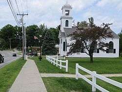
- The Center Meeting House
- Veterans Memorial at Newbury
References
- ↑ United States Census Bureau, American FactFinder, 2010 Census figures. Retrieved March 23, 2011.
- ↑ "Annual Estimates of the Resident Population for Incorporated Places: April 1, 2010 to July 1, 2015". Retrieved July 2, 2016.
- ↑ "Census of Population and Housing". Census.gov. Retrieved June 4, 2016.
- ↑ "American FactFinder". United States Census Bureau. Retrieved 2008-01-31.
External links
| Wikimedia Commons has media related to Newbury, New Hampshire. |
- Town of Newbury official website
- Lake Sunapee Protective Association
- Lake Sunapee - History - Old Photos and Postcards
- Mount Sunapee State Park
- New Hampshire Economic and Labor Market Information Bureau Profile
- Sunapee-Ragged-Kearsarge Greenway Coalition
Municipalities and communities of Merrimack County, New Hampshire, United States | ||
|---|---|---|
| Cities | 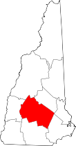 | |
| Towns | ||
| CDPs | ||
| Other unincorporated communities | ||
| Footnotes | ‡This populated place also has portions in an adjacent county or counties | |