New Zealand State Highway 1
| ||||
|---|---|---|---|---|
 | ||||
| Route information | ||||
| Maintained by New Zealand Transport Agency | ||||
| Length: | 2,047 km (1,272 mi) | |||
| Tourist routes: |
Twin Coast Discovery Highway Thermal Explorer Highway Classic New Zealand Wine Trail Alpine Pacific Triangle Southern Scenic Route | |||
| Major junctions | ||||
| North end: | Cape Reinga | |||
| South end: | Bluff | |||
| Location | ||||
| Primary destinations: | Whangarei, North Shore, Auckland, Manukau, Hamilton, Taupo, Porirua, Wellington, Picton, Blenheim, Christchurch, Ashburton, Timaru, Oamaru, Dunedin, Gore, Invercargill | |||
| Highway system | ||||
| ||||

State Highway 1 (SH 1) is the longest and most significant road in the New Zealand roading network, running the length of both main islands. It appears on road maps as SH 1 and on road signs as a white number 1 on a red shield, but it has the official designations SH 1N in the North Island, SH 1S in the South Island.
SH 1 is 2047 km long, 1106 km in the North Island and 941 km in the South Island. For most of its length it is a two-lane single carriageway, with at-grade intersections and property accesses, in both rural and urban areas. These sections have some passing lanes. There are sections of motorway in the vicinity of Auckland, Hamilton, Wellington, Christchurch and Dunedin.
Route
North Island (SH 1N)
SH 1 starts at Cape Reinga, at the northwestern tip of the Aupouri Peninsula, and since April 2010 has been sealed (mainly with either chipseal or asphalt) for its entire length.[1] From Waitiki Landing south of Cape Reinga, SH 1 travels down the central-eastern side of the peninsula to Kaitaia, New Zealand's northernmost town, before turning south-east across the Northland Peninsula on to Kawakawa in the Bay of Islands, and then south to the city of Whangarei, the largest urban area in Northland.
SH 1 then skirts the south-western Whangarei Harbour, nearing the coast briefly at Ruakaka, before proceeding down to wind through the Brynderwyn Hills before approaching the upper reaches of the Kaipara Harbour. The highway crosses into the Auckland Region, and passes through Wellsford and Warkworth, again heading for the east coast.
Near Puhoi, on the Hibiscus Coast, SH 1 becomes the Auckland Northern Motorway, the main road north of New Zealand's largest urban area. The first 7 km of the motorway is an automated toll road, with the toll being NZ$2.30 each way for cars and motorcycles and $4.70 for trucks.[2] At Orewa, the motorway becomes toll-free, crossing farmland to the North Shore of Auckland. The road crosses through suburbs to the Waitemata Harbour, which it briefly follows before crossing it by the Auckland Harbour Bridge, New Zealand's second-longest and most widely recognised road bridge. The motorway comes off the bridge into Auckland's city centre, and forms its western boundary as SH 1 proceeds to the Central Motorway Junction.
At this junction (also known as Spaghetti Junction), SH 1 becomes the Auckland Southern Motorway, and, after sweeping around the southern end of central Auckland, proceeds in a south-easterly direction. The section from the Central Motorway Junction and the Newmarket Viaduct, 3 km to the south, is the country's busiest section of road, with more than 200,000 vehicle movements a day between Khyber Pass Road and Gillies Ave.[3] The motorway continues in a broadly southeast direction across the Auckland isthmus, then through Manukau and Papakura to the top of the Bombay Hills, just short of the Auckland/Waikato boundary.
At Bombay, SH 1 becomes the Waikato Expressway, a four-lane dual-carriageway expressway. The expressway takes the highway down the Bombay Hills to Mercer, where SH 1 meets the Waikato River which it follows for the next 130 km. The Waikato Expressway temporarily ends at Longswamp and becomes a three-laned dual carriageway, resuming south of Rangiriri before reverting to single carriageway just south of Ohinewai. A $650 million project is underway to upgrade the existing Longswamp[4] to Rangiriri section,[5] and to extend the expressway from Ohinewai to Taupiri and from Horotiu to Tamahere.
SH 1 runs as a single carriageway through Huntly to Taupiri, where the Waikato Expressway resumes. The expressway ends in north-western Hamilton, New Zealand's largest inland and fourth-largest city. The highway bypasses the city centre to the west, before crossing to the east side and proceeding south-east out of the city. The expressway resumes at Tamahere, bypassing Cambridge to the north before reverting to a single carriageway east of the town.
SH 1 continues along the shore of Lake Karapiro, the last of eight artificial lakes on the Waikato River. At Piarere, SH 1 leaves the actual Waikato River, but continues to follow in its general direction. The highway continues to the town of Tirau, where it turns south to pass through Putaruru and Tokoroa and the surrounding exotic pine plantation forest area.
SH 1 meets the Waikato River again at Wairakei, where it crosses the river and takes an eastern course around the town of Taupo to meet Lake Taupo, the Waikato's source and the largest lake in New Zealand, south of the town. SH 1 follows the eastern shore of the lake for 50 km to Turangi, at the southern end of the lake.
Turning southwards again, SH 1 leaves Turangi and ascends onto the North Island Volcanic Plateau, passing through the fringes of the Tongariro National Park and into the Rangipo Desert, passing the volcanoes of Ruapehu, Ngauruhoe and Tongariro. The road between Rangipo (10 km south of Turangi) and Waiouru is commonly known as the Desert Road, and is frequently closed by snow during winter. At km 794 on the Desert Road, SH 1 is 1,074 metres (3,524 ft) above sea level - the highest point on the New Zealand State Highway network.[3] SH 1 enters the Manawatu-Wanganui Region, and descends through an army training area to the end of the Desert Road at Waiouru.
From Waiouru, the highway follows tributaries of the Rangitikei River through Taihape to Mangaweka, where the highway meets the river. It then followes the western bank of the Rangitikei through Ohingaiti and Hunterville to Bulls. At Bulls, SH 1 turns southeast to cross the river, turning southwest again 5 km down the road at Sanson. SH 1 crosses the Manawatu Plain, passing the city of Palmerston North about 20 km west of it. It passes through Foxton, before reaching the end of the plain at Levin.
From Levin, SH 1 follows the narrowing western coastal plain southwards, and crosses into the Wellington Region 15 km south of Levin. The road passes through Otaki and Waikanae to the main town of the Kapiti Coast, Paraparaumu. The highway is dotted with a large number of satellite towns and villages, and combined with the narrowness of the road, difficult terrain, and the high traffic flow, the stretch of highway between Levin and Paraparaumu is an area of considerable congestion and a high number of accidents.
.jpg)
From Paraparaumu, the road is briefly a four-laned dual carriageway to Mackays Crossing, returning to a two-laned single carriageway and passing through Paekakariki. Between Paekakariki and Pukerua Bay, SH 1 and the North Island Main Trunk rail line travel along a narrow strip of land between the hills and the sea. The Centennial Highway, as it is known, is a narrow two-lane road that was highly accident prone until a centreline wire rope crash barrier was installed. Travelling through Pukerua Bay, the road becomes dual carriageway once more to Plimmerton, narrowing to single carriageway off peak and dual carriageway at peak, through the northern suburbs of Porirua to Paremata. This section between Mackays Crossing and Porirua is planned to be relieved by the billion-dollar inland Transmission Gully Motorway, scheduled to be completed by 2020.
At Paremata, SH 1 resumes as dual carriageway along the edge of the Porirua Harbour to Porirua city centre. At Porirua, the highway becomes the Johnsonville-Porirua Motorway, and travels into the northern suburbs of Wellington, New Zealand's capital city. The motorway ends at Johnsonville, and SH 1 descends through the Ngauranga Gorge to the Ngauranga Interchange, on the shore of Wellington Harbour. At the interchange, traffic leaves for the Cook Strait ferries to Picton and the South Island. Ferry services operate frequently to allow vehicular, passenger, and rail traffic to access the South Island. There have been calls for the ferries to be classified as part of the State Highway network, in the belief that this would increase the Government's powers to intervene and keep them running at times of industrial action.
At Ngauranga, SH 1 becomes the Wellington Urban Motorway, skirting the shore of the harbour then passing the city centre to the west. The motorway ends at Te Aro, where a one-way system takes traffic to the Basin Reserve. Northbound traffic uses the recently opened Wellington Inner City Bypass, while southbound traffic uses Vivian Street. From the Basin Reserve, SH 1 travels through the Mount Victoria Tunnel to Wellington's eastern suburbs and Wellington International Airport. SH 1 ends at a roundabout at the entrance to the airport.
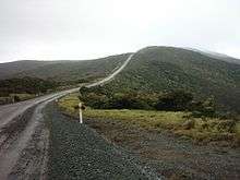 SH 1 near Cape Reinga. Sealing of this section was completed in April 2010.
 An unusual situation at Kawakawa, where traffic on the country's premier highway must stop and give preference to SH 11 traffic.
 SH 1 as the Auckland Northern Motorway, looking north from Forrest Hill, North Shore.
 SH 1 crossing the Auckland Harbour Bridge.
 SH 1 through the Central Motorway Junction ("Spaghetti Junction").
 SH 1, as the Southern Motorway, in Otahuhu, Auckland
 Travelling north on SH 1 through the Rangipo Desert. This section is known as the Desert Road, and is frequently closed by snow in winter.
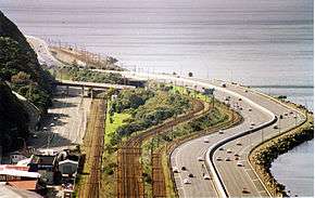 SH 1 as the Wellington Urban Motorway, running beside Wellington Harbour.
South Island (SH 1S)
From the Picton ferry terminal, SH 1 is steep, crossing a saddle into the valley of the Tuamarina River. It descends alongside this river and across the Wairau Plain before reaching Blenheim. From Blenheim the road travels briefly through some of Marlborough's famous vineyards, then passes the lower slopes of the steep Kaikoura Ranges where the road has occasional glimpses of the sea to the east over Lake Grassmere. This stretch is one of the most scenic, with the Pacific Ocean on one side and 2500 m peaks on the other. From the small town of Ward the highway heads to the coast and follows it to Kaikoura. After passing Kaikoura, it veers inland, twisting tortuously through the Hundalee Ranges before emerging at the northern end of the Canterbury Plains.
SH 1 passes through Amberley and Woodend before becoming the Christchurch Northern Motorway and bypassing Kaiapoi to the west. The motorway crosses the Waimakariri River and ends just north of Belfast. SH 1 bypasses inner Christchurch to the north-west via the outer suburbs of Harewood, past the Christchurch International Airport, and Yaldhurst. At Hornby, the highway turns south-west and passes through Templeton and Rolleston.
South of Rolleston, SH 1 becomes virtually straight as it crosses the wide fan of the Canterbury plains, crossing the country's longest road bridge at Rakaia before reaching Ashburton, and then veering back towards the coast, which it reaches at Timaru. Between Ashburton and Timaru it crosses Rangitata Island in the Rangitata River.
South of Timaru, the road again passes through gentle hill country, staying close to the coast but largely out of sight of it. The road veers inland briefly, bypassing Waimate as it reaches the plains around the mouth of the Waitaki River, which it crosses to enter Otago. It passes through Oamaru, from where it turns inland briefly, crossing undulating hill country before again reaching the coast at Moeraki. From here the road again hugs the coast along Katiki Beach, remaining closer to the ocean than at any point since Kaikoura. The highway turns inland at Shag Point, passing through Palmerston and Waikouaiti.
South of Waikouaiti the road again becomes steep, rising sharply over the Kilmog hill before dropping down to the coast at Blueskin Bay, then rising again via Dunedin-Waitati Highway (a two- to four-lane carriageway which used to be designated a motorway) to the northern outskirts of Dunedin. From here it descends a steep, twisting stretch of Pine Hill Road through Pine Hill, before passing the University of Otago and heading through the city centre. For much of its route through Central Dunedin the highway is split into two separate northbound and southbound roads, part of the city's one-way street system. These roads traverse the central city 2-3 blocks southeast of the heart of the CBD. At the southern end of central Dunedin, the highway becomes the Caversham By-pass, which rises along the Caversham Valley before again becoming a motorway at the saddle of Lookout Point.
The four-lane motorway (Dunedin Southern Motorway) runs through Dunedin's southern suburbs until the interchange with SH 87 at Mosgiel. SH 1 then heads southwest across the Taieri Plains. The area between the Taieri and Waipori Rivers is flood-prone, and the highway crosses this on a major embankment known colloquially as the flood-free highway. SH 1 continues through gentle hill country and along the shore of Lake Waihola, then crosses the Tokomairaro Plains into Milton. South of Milton is a major junction with SH 8 at Clarksville Junction. SH 1 continues to cross rolling hill country to reach Balclutha.
From Balclutha, the highway turns west, veering briefly north as it heads inland to avoid the rough hills of The Catlins. It passes through the small town of Clinton before reaching the major provincial town of Gore. Because of the names of these two towns, this stretch of the highway was christened "The Presidential Highway" during the time of the Clinton-Gore administration in the United States. At Gore the highway crosses the Mataura River; from here the road again turns south to roughly follow the river. The highway passes through Mataura before turning west at Edendale. Many travellers choose to turn onto SH 93 at Clinton, as this route offers a shorter journey between Clinton and Mataura and bypasses Gore. Over its last stretch the road veers southwest before reaching the city of Invercargill. In central Invercargill it meets the southern end of SH 6 and turns due south, skirting the estuary of the New River and Bluff Harbour. It passes through the small town of Bluff before reaching its terminus at Stirling Point, a kilometre south of Bluff. A commemorative signpost at Stirling Point indicates distances to major world centres and to the start of the highway at Picton.
 SH 1 passing through the North Canterbury town of Cheviot
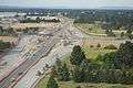 Four-laning of SH1 in Harewood, Christchurch and grade-separating at Memorial Avenue is under construction
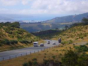 Dunedin-Waitati Hwy looking north from near the Pigeon Flat Overbridge. Blueskin Bay is visible in the background
 In Dunedin, the highway forms a pair multi-lane one-way streets. Cumberland Street, 1 km south of the city centre.
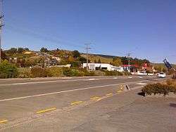 SH 1 in the Otago town of Waihola.
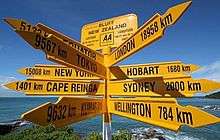 Signpost at Stirling Point, Bluff.
Spur sections
SH 1N has one spur, SH 1B from SH 1N at Taupiri to SH 1N at Cambridge, providing an eastern bypass of Hamilton.
SH 1S has one spur, SH 1D in Dunedin's southern suburbs, from SH 1S interchange at Abbotsford, passing through the suburbs of Sunnyvale and Fairfield before joining SH 1S at the Saddle Hill interchange. SH 1D was the former route of State Highway 1 before the completion of the Fairfield bypass motorway in 2003. It is a State Highway on paper only - it is not signposted as a State Highway, and it appears as a local arterial road on maps.
Road conditions
SH 1 has varied road conditions. For most of its length it is a two-lane single carriageway road with at-grade intersections and access, sealed with chipseal in rural areas or asphalt in urban and high-traffic areas. The highway has frequent passing lanes on these sections, to allow traffic to pass other vehicles safely. Parts of the road are steep by international standards. Most steep sections having a combination of passing lanes (uphill), and crawler lanes or stopping bays (downhill) to allow heavy and slow vehicles to pull out of the way to let other vehicles pass.
The New Zealand Transport Agency (NZTA) classifies the most part of State Highway 1 as a national strategic road. The exceptions are between Kawakawa and Whangarei and south of Mosgiel, where the SH 1 is classified as a regional strategic road, and north of Kawakawa where SH 1 is classified as a primary collector road. The sections between Wellsford and Wairakei, between Ohau and Wellington Airport, and between Woodend and Rolleston are classified as high volume roads.[6][7]
NZTA announced in September 2010 that it was replacing the last three fords on SH 1S. The shingle fan fords are near Kaikoura, and while generally being dry, on about 28 days a year state highway traffic used to detour around them due to high water levels on old single-lane bridges, leading to delays on a major freight route. With the detour bridges reaching the end of their lifespan, NZTA replaced the fords with culverts.[8]
Route changes
Construction of motorways has diverted the route in many places. A large section of SH 1N via Orewa, Dairy Flat and central Albany was bypassed between Silverdale and Albany in 1999 and 2009 by extensions of the Auckland Northern Motorway. The former route was re-designated SH 17, but this designation was revoked shortly after. The extension of the Dunedin Southern Motorway has also seen changes in the highway, notably to bypass the suburbs of Fairfield and Sunnyvale.
In Hamilton, SH 1N originally ran through the city centre rather than via Frankton. The original route was via Te Rapa Road, Ulster Street (first agreed as an alternative to the northern end of Victoria St in 1930),[9] Victoria Street, Bridge Street and Cobham Drive, which is now Hamilton Urban Route 4. The current highway was diverted via Avalon Drive, Greenwood Street, Kahikatea Drive and Normandy Avenue. Continued improvements have meant SH 1N now bypasses a number of small towns in the northern Waikato.
The route north of Wellington known as the Centennial Highway from Ngauranga to Paekakariki was started in 1936 and opened on 4 November 1939.[10] The Centennial Highway project involved an upgrade of the Ngauranga Gorge road and provided a new route from Paremata to Paekakariki, bypassing the winding road along the southern harbour edge from Paremata to Pauatahanui and the tortuous narrow winding Paekakariki Hill Road between Pauatahanui and Paekakariki. It followed a new route, bridging the narrow channel between Paremata and the Mana isthmus and following the eastern edge of the Taupo swamp north of Plimmerton before climbing to the Pukerua Bay saddle and descending to follow the coastline to Paekakariki.[11]
In Porirua city, in the 1990s, the road was four-laned and realigned to ease curves from just south of Pukerua Bay to Mana. In 2005-2006, SH1 through Mana was upgraded with extra lanes to provide dual carriageways through Mana during peak periods and the installation of traffic lights to regulate cross traffic. A second bridge was added to four-lane the connection of the Mana isthmus to Paremata.
The first section of the four-lane Johnsonville–Porirua Motorway, New Zealand's first motorway, opened on Saturday 23 December 1950. Running for three miles (5 km) from Johnsonville to Takapu Road at the southern edge of Tawa, it bypassed a winding two-lane road now called Middleton Road, through Glenside.[12][13] The second section of the motorway running for four miles (6 km) from Takapu Road to Porirua opened about 1956 bypassing the Main Road through Tawa and narrow winding sections of road at the northern and southern entrances to Tawa. Soon afterwards the four-lane Johnsonville bypass opened connecting Ngauranga Gorge to the Johnsonville–Porirua Motorway, bypassing Johnsonville Road through the town centre of Johnsonville.
A four-lane expressway from Porirua to Paremata built on reclaimed land on the eastern side of Porirua Harbour opened in the early 1960s, bypassing the winding two-lane road that followed the former coastline. Construction of the new road created Aotea Lagoon and the remaining section of the old road is now known as Papakowhai Road. Construction of a Motorway interchange and flyover to connect Mungavin Avenue to Titahi Bay Road about the same time allowed the Johnsonville-Porirua Motorway to be connected to the Porirua-Paremata Expressway. In the early 1970s, a new flyover was constructed at the northern entrance to Porirua City centre to replace the original disintegrating late 1930s Centennial Highway flyover and the number of southbound lanes between Whitford Brown Avenue and the flyover was increased from two to three.
In 1984, the Ngauranga Interchange opened, connecting State Highway 1 to the Wellington Urban Motorway, removing the State Highway designation from the Hutt Road south of Ngauranga, and making the Wellington Urban Motorway between Ngauranga and Aotea Quay both State Highway 1 and 2.
In Christchurch, SH 1S originally ran via the city centre rather than around the outskirts via Harewood. The original route was via Main North Road, Cranford Street, Sherborne Street, Bealey Avenue, Madras and Gasson Streets (north)/Barbadoes Street and Waltham Road (south), Brougham Street, the Christchurch Southern Arterial Motorway, Curletts Road, Blenheim Road, and Main South Road. The section from the Queen Elizabeth II Drive to Brougham Street is now a local road, while the remainder of the route forms parts of SH 74 and 76.
Re-routing also occurred in Whangarei and Timaru, removing SH 1 from their city centres. The original route through Whangarei via Kamo Road, Bank Street, Water Street and Maunu Road was diverted via Western Hills Drive, while the original route through Timaru via Stafford and King Streets was diverted via Theodosia Street and Craigie Avenue.
Most recently, the Taupo Bypass was constructed shifting the original SH 1 from the township and lakeside to the eastern outskirts of Taupo. The bypass starts at Wairakei near the existing SH 1/SH 5 intersection and finishes to the north of Taupo Airport. The concurrency with SH 5 also follows part of the bypass.
In the southern South Island, several particularly twisting sections of SH 1S have been rebuilt to remove sharp bends and to generally improve road conditions. These include stretches at Normanby, near Timaru; Waianakarua; at Tumai, near Palmerston; and on the Dunedin Northern Motorway near Waitati. An extensive section between Allanton and the Taieri River was realigned during the 1970s.
Former spurs
SH 1A ran from Orewa to Silverdale. When the Northern Gateway Toll Road opened, part of SH 1A was incorporated into SH 1N and the rest had its highway status revoked.
SH 1F was the name previously given to the northernmost section of SH 1N – between Cape Reinga and the junction with SH 10. This section is no longer a spur and is now part of SH 1N.
Future improvements
State Highway 1 has been earmarked for several motorway projects most of which have surfaced from the National governments Roads of National Significance package announced in 2009.
Auckland
The most controversial project is the Puhoi to Wellsford highway (Ara Tūhono) motorway. This is also referred to as the "Holiday Highway" as the current SH 1 becomes heavily congested in holiday periods from holidaymakers travelling to and from Auckland in the summer holiday season and public holiday weekends. At this stage NZTA are investigating the section from Puhoi to Warkworth section, with no funding yet approved, and it is likely the extended section to Wellsford will not be looked at for some time to come.[14]
Many ideas have come forth to create a Second Harbour Crossing over Waitemata Harbour to complement the aging Auckland Harbour Bridge.[15] These include ideas for a second bridge, or a second tunnel with capacity for rail. At this stage, any meaningful progress is unlikely until at least 2025.[16]
Waikato
The Waikato Expressway has been under construction for much of the previous ten years, with most of the nine sections now funded or commencing construction. The Cambridge[17] section which sees SH 1 bypass the township to the north was completed in late 2015. The two biggest most complex sections, the Huntly[18] section which bypasses Huntly to the east of the township and the Hamilton[19] section bypassing the city of Hamilton to the east, commenced construction in 2015 and 2016 respectively. All sections are estimated to be completed in 2020 meaning SH 1 from Puhoi (north of Auckland) to south of Cambridge will be entirely motorway or expressway, significantly reducing travel time through the Waikato Region by up to 35 minutes.
Kapiti/Wellington
As part of the Roads of National Significance package, there are plans to upgrade SH 1 from south of Levin to Wellington Airport. Three expressway sections are planned, which are Peka Peka to Ōtaki,[20] Mackays to Peka Peka[21] and the highly controversial Transmission Gully Motorway[22] which connects Mackays to Linden bypassing much of Porirua City.
Many inner city Wellington projects are also planned for SH 1 including duplication of the Terrace Tunnel and Mt Victoria tunnels. However these projects look uncertain as another planned project, the Basin Reserve Flyover failed to obtain the necessary resource consents and an appeal was rejected in the High Court.[23]
Canterbury
NZTA are currently constructing the Western Belfast Bypass, a spur from the Christchurch Northern Motorway that will carry SH 1 traffic away from Belfast. Belfast is a significant congestion point on the northern corridor so the bypass will help relieve congestion for motorists traveling into Christchurch via Main North Road and also via SH 74 to the Lyttelton Port. The Western Belfast Bypass will be built to motorway status as far as the Groynes and is expected to be completed in 2018.[24]
SH 1 to the west of Christchurch along Johns Road, Russley Road, Masham Road and Carmen Road is also being upgraded to four lanes from the Groynes to Main South Road in Hornby. Some sections have already been completed while the remaining sections are currently under construction. A grade separated interchange will also be build at the intersection of Memorial Avenue, the thoroughfare which connects the city to Christchurch International Airport.[25] SH 1 traffic will travel underneath Memorial Avenue.
NZTA are also investigating extending the Christchurch Northern Motorway so that it bypasses the town of Woodend.[26]
Other improvements
Several smaller projects are being undertaken to improve sections of SH 1. These include:
- Realigning the highway and adding a northbound passing lane at Akerama, between Kawakawa and Whangarei.
- Safety improvements to the highway between Otaika (Loop Road North) and the southern end of Whangarei (Smeatons Hill).
- Replacing the end-of-life Whirokino Trestle and Manawatu River bridges south of Foxton with new bridges.[27]
- Safety improvements to the highway between Spring Creek and Blenheim, including a new roundabout at the intersection with SH 62 and replacing the narrow Opawa River Bridge with a new bridge.[28]
- Bypassing the town of Edendale to the west of the Fonterra milk processing plant.[29]
Major junctions
North Island (SH 1N)
| Territorial authority | Location | Km | Jct | Destinations | Notes |
|---|---|---|---|---|---|
| Far North District | Cape Reinga | 0 | SH 1 begins 34°25′45″S 172°40′54″E / 34.42928°S 172.681582°E | ||
| Awanui | 104 | | | SH 1/Twin Coast Discovery Highway concurrency begins. Originally the start of SH 1. The highway north of here was SH 1F. | |
| Kaitaia | 112 | | Twin Coast Discovery Highway (South Road) – Town Centre, Ahipara | SH 1/Twin Coast Discovery Highway concurrency ends | |
| Okaihau | 184 | | | ||
| Ohaeawai | 190 | | | ||
| Pakaraka | 198 | | | ||
| Kawakawa | 211 | | | SH 1/Twin Coast Discovery Highway concurrency begins | |
| Whangarei District | Whangarei | 266 | | | |
| Otaika | 272 | | | SH 1/SH 15 concurrency begins | |
| Ruakaka | 292 | | | SH 1/SH 15 concurrency ends | |
| Waipu | 303 | | Twin Coast Discovery Highway (Nova Scotia Drive) – Waipu, Mangawhai Heads | SH 1/Twin Coast Discovery Highway concurrency ends | |
| Kaipara District | Brynderwyn | 319 | | | SH 1/Twin Coast Discovery Highway concurrency begins |
| Auckland | Te Hana | 339 | | Twin Coast Discovery Highway (Mangawhai Road) – Tomarata, Mangawhai | |
| Wellsford | 346 | | | ||
| Puhoi | 388 | | Twin Coast Discovery Highway – Auckland (via Waiwera) | Formerly SH 17. Toll-free route south SH 1/Twin Coast Discovery Highway concurrency ends | |
| Orewa | 393 | Toll point | |||
| Silverdale | 398 | | (Hibiscus Coast Highway) | Formerly SH 17. Toll-free route north | |
| Albany | 412 | | Greville Road – Browns Bay, Massey University, Albany | Formerly SH 17 | |
| Unsworth Heights | 414 | | | ||
| Northcote Point | 423 | | Auckland Harbour Bridge (Waitemata Harbour) | ||
| Auckland CBD | 426 | | | Southbound exit and northbound entrance Auckland Northern Motorway becomes Auckland Southern Motorway | |
| 428 | | | Northbound exit and southbound entrance | ||
| 429 | | | Northbound exit and southbound entrance | ||
| Manukau CBD | 449 | | | ||
| Drury | 461 | | | ||
| Bombay | 471 | | (Mill Road) – Bombay, Pukekohe | Auckland Southern Motorway becomes | |
| Waikato District | Pokeno | 477 | | | 37°13′49″S 175°00′57″E / 37.230257°S 175.015769°E |
| Hampton Downs | 494 | | (Hampton Downs Road) | Waikato Expressway ends | |
| Taupiri | 527 | | | Waikato Expressway resumes | |
| Horotiu | 538 | | Waikato River | ||
| 542 | | | |||
| Hamilton City | Rotokauri | 546 | | (Wairere Drive) – Te Rapa, Chartwell | Northbound exit and southbound entrance only Waikato Expressway ends |
| Frankton | 551 | | | ||
| Melville | 553 | | | 37°48′30″S 175°16′50″E / 37.808279°S 175.2805149°E | |
| 555 | | Waikato River (Cobham) Bridge | |||
| Riverlea | 556 | | | ||
| Waikato District | Tamahere | 559 | | (Bollard Road) | Waikato Expressway resumes |
| 560 | | | |||
| Waipa District | Cambridge | 572 | | | |
| 577 | | (Tirau Road) – Cambridge, Te Awamutu | Waikato Expressway ends | ||
| Matamata-Piako District | District contains no major junctions | ||||
| Piarere | 594 | | | Intersection lies on the border between the two districts | |
| South Waikato District | |||||
| Tirau | 605 | | | ||
| 607 | | | SH 1/Thermal Explorer Highway concurrency ends 37°59′06″S 175°46′04″E / 37.9849°S 175.767689°E | ||
| Putaruru | 613 | | | ||
| Tokoroa | 638 | | | ||
| Upper Atiamuri | 657 | | | SH 1/SH 30 concurrency begins | |
| Atiamuri | 663 | | | SH 1/SH 30 concurrency ends | |
| | Waikato River | ||||
| Taupo District | |||||
| Wairakei | 695 | | (Wairakei Drive) – Taupo | SH 1/SH 5/Thermal Explorer Highway concurrency begins 38°37′24″S 176°05′59″E / 38.62344°S 176.09970°E | |
| Taupo | 696 | | Waikato River | ||
| 706 | | (Napier Road) – Taupo | SH 1/SH 5/Thermal Explorer Highway concurrency ends 38°42′16″S 176°06′43″E / 38.70446°S 176.11198°E | ||
| Turangi | 753 | | | ||
| Rangipo | 763 | | | Desert Road begins | |
| Desert Road | 794 | Desert Road Summit 1,074 m (3,524 ft) | 39°17′35″S 175°44′29″E / 39.293192°S 175.741339°E | ||
| Ruapehu District | |||||
| Waiouru | 815 | | | Desert Road ends | |
| Rangitikei District | Vinegar Hill | 885 | | | |
| Marton | | North Island Main Trunk Bridge 105 (max height 4.40 m) | High bridge strike risk | ||
| Bulls | 925 | | | SH 1/SH 3 concurrency begins 40°10′28″S 175°23′04″E / 40.174577°S 175.38431°E | |
| 927 | | Rangitikei River | |||
| Manawatu District | Sanson | 931 | | | SH 1/SH 3 concurrency ends 40°13′13″S 175°25′27″E / 40.220158°S 175.424151°E |
| Horowhenua District | 966 | | Manawatu River | ||
| Ohau | 985 | | | ||
| Kapiti Coast District | District contains no major junctions | ||||
| Porirua City | Paremata | 1050 | | | |
| Porirua CBD | 1055 | | Mungavin Avenue – Porirua, Titahi Bay, Tawa | | |
| Wellington City | Johnsonville | 1065 | | Johnsonville Road – Johnsonville | Johnsonville-Porirua Motorway ends |
| Ngauranga | 1068 | | | 41°14′49″S 174°48′52″E / 41.247063°S 174.814517°E | |
| Te Aro | 1075 | | Willis Street | Wellington Urban Motorway ends | |
| Rongotai | 1081 | | (Broadway) – Strathmore, Seatoun (Stewart Duff Drive) – Airport | SH 1 ends 41°19′33″S 174°48′35″E / 41.32577°S 174.809625°E | |
South Island (SH 1S)
| Territorial authority | Location | Km | Jct | Destinations | Notes |
|---|---|---|---|---|---|
| Marlborough District | Picton Railway Station | 0 | SH 1 begins | ||
| Picton | 1 | | | SH 1/Classic New Zealand Wine Trail concurrency begins | |
| Tuamarina | 20 | | Wairau River | ||
| Spring Creek | 23 | | | ||
| Blenheim | 28 | | | ||
| 29 | | Park Terrace Redwood Street – Redwoodtown Main Street – Town Centre Main North Line | Rail line bisects roundabout Classic NZ Wine Trail and SH 1/Classic NZ Wine Trail concurrency ends. | ||
| Seddon | 50 | | Awatere River | ||
| Kaikoura District | Kowhai | 163 | | | SH 1/Alpine Pacific Triangle concurrency begins |
| Hurunui District | Ethelton | 247 | | Hurunui River | Only remaining one-lane bridge on SH 1S |
| Waipara | 284 | | | ||
| Amberley | 291 | | | Alpine Pacific Triangle ends. SH 1/Alpine Pacific Triangle concurrency ends. | |
| Waimakariri District | Pineacres | | William Street | | |
| Kaiapoi | 323 | | | ||
| Christchurch City | Belfast | | Main North Road Dickeys Road | Christchurch Northern Motorway ends | |
| 332 | | | |||
| Harewood | 341 | | Memorial Avenue east – Fendalton, City Centre | Grade-separated interchange replacement due to open 2018. | |
| Masham | 344 | | | ||
| Hornby | 347 | | Main South Road – City Centre, Lyttelton, Akaroa | Formerly SH 73A | |
| Islington | 349 | | | ||
| Selwyn District | District contains no major junctions | ||||
| Rakaia | 400 | | Rakaia Bridge (Rakaia River) 1.76 km (1.09 mi) | Longest road bridge in New Zealand | |
| Ashburton District | |||||
| Ashburton | 430 | | | ||
| Timaru District | Rangitata | 465 | | | |
| Winchester | 481 | | | ||
| Washdyke | 501 | | | ||
| Timaru | 506 | | | ||
| Waimate District | Makikihi | 543 | | | |
| Glenavy | 569 | | Waitaki River | ||
| Waitaki District | |||||
| Pukeuri Junction | 583 | | | ||
| Palmerston | 651 | | | ||
| Dunedin City | Dunedin Central | 706 | | | |
| Caversham | 709 | | | ||
| Lookout Point | 710 | | (Main South Road) | SH 1 becomes | |
| Mosgiel | 720 | | | ||
| 721 | | (Braeside) | Dunedin Southern Motorway ends | ||
| Allanton | 729 | | | ||
| 736 | | Taieri River | |||
| Clutha District | Waihola | 746 | | | SH 1/Southern Scenic Route concurrency begins |
| Clarksville | 765 | | | ||
| Balclutha | 786 | | Balclutha Bridge (Clutha River) | ||
| 787 | | | SH 1/Southern Scenic Route concurrency ends | ||
| Clinton | 817 | | | ||
| Gore District | McNab | 854 | | | |
| Gore | 858 | | Mataura River | ||
| | | ||||
| Mataura | 870 | | | ||
| 872 | | | |||
| Southland District | Dacre | 900 | | | Alternative route to SH 6 and SH 99, bypassing Invercargill |
| Invercargill City | Invercargill City Centre | 922 | | | SH 1/Southern Scenic Route concurrency begins |
| 923 | | | SH 1/Southern Scenic Route concurrency ends | ||
| Bluff | 952 | SH 1 ends | |||
SH 1B
| Territorial authority | Location | Km | Jct | Destinations | Notes |
|---|---|---|---|---|---|
| Waikato District | Taupiri | 0 | | | SH 1B begins |
| | | ||||
| Newstead | 27 | | | SH 1B/SH 26 concurrency begins | |
| 28 | | | SH 1B/SH 26 concurrency ends | ||
| Waipa District | Cambridge | 42 | | | SH 1B ends |
| | (Victoria Road) – Cambridge |
See also
- List of New Zealand state highways
- List of roads and highways, for notable or famous roads worldwide
References
| Wikimedia Commons has media related to State Highway 1 (New Zealand). |
- ↑ "Final few metres of SH1 sealed". New Zealand Herald. 22 April 2010. Retrieved 21 September 2010.
- ↑ "Toll roads". NZTA. Retrieved 2015-11-29.
- 1 2 "State highway frequently asked questions". NZTA.
- ↑ "Longswamp". Nzta.govt.nz.
- ↑ "Rangiriri". Nzta.govt.nz.
- ↑ "One Network Road Classification: North Island State Highways" (PDF). New Zealand Transport Agency. Retrieved 9 February 2016.
- ↑ "One Network Road Classification: South Island State Highways" (PDF). New Zealand Transport Agency. Retrieved 9 February 2016.
- ↑ "End of the road for last traffic fords left on State Highway 1". Media statement. NZTA, Christchurch Regional Office. 27 September 2010. Retrieved 29 September 2010.
- ↑ Zealand, National Library of New. "TOO MANY ACCIDENTS. (New Zealand Herald, 1930-06-20)". paperspast.natlib.govt.nz. Retrieved 2016-07-24.
- ↑ Reilly, Helen (2013). Pauatahanui: A local history. Wellington: Pauatahanui Residents Association. pp. 128–129. ISBN 978-0-473-25439-1.
- ↑ Centennial Highway, State Highway 1 (Ngauranga Gorge to Paekakariki), ENGINEERING HERITAGE NEW ZEALAND, IPENZ, accessed 6 October 2016
- ↑ Dominion 27 December 1950 page 11; Evening Post 21 December 1950 page 6, 27 December 1950 page 10 (photos)
- ↑ Transit New Zealand - FAQ
- ↑ "Ara Tūhono – Pūhoi to Wellsford". Nzta.govt.nz.
- ↑ "SH1 Additional Waitematā Harbour Crossing project". Nzta.govt.nz.
- ↑ "Plan to 'future-proof' second Waitemata Harbour crossing". NZ Herald. 16 March 2015.
- ↑ "Cambridge". Nzta.govt.nz.
- ↑ "Huntly". Nzta.govt.nz.
- ↑ "Hamilton". Nzta.govt.nz.
- ↑ "Peka Peka to Ōtaki Expressway". Nzta.govt.nz.
- ↑ "MacKays to Peka Peka Peka". Nzta.govt.nz.
- ↑ "Transmission Gully Motorway". Nzta.govt.nz.
- ↑ "Basin Reserve flyover project killed off by the High Court". Stuff.co.nz. Retrieved 21 August 2015.
- ↑ "Western Belfast Bypass; NZ Transport Agency". Nzta.govt.nz.
- ↑ "SH 1 Russley Road; NZ Transport Agency". Nzta.govt.nz.
- ↑ "Woodend Corridor Improvements; NZ Transport Agency". Nzta.govt.nz.
- ↑ "Whirokino Trestle and Manawatu River Bridge". New Zealand Transport Agency. Retrieved 22 March 2016.
- ↑ "Key's state of the nation - full speech". NZHerald.co.nz. Retrieved 2016-01-27.
- ↑ "Edendale State Highway 1 bypass". NZ Transport Agency. Retrieved 19 March 2016.
External links
| National | ||
|---|---|---|
| North Island |
| |
| South Island | ||
| Former state highways | ||
| Touring routes |
| |